Country:
 Mexico
Region:
City:
Latitude and Longitude:
Time Zone:
Postal Code:
IP information under different IP Channel
ip-api
Country
Region
City
ASN
Time Zone
ISP
Blacklist
Proxy
Latitude
Longitude
Postal
Route
IPinfo
Country
Region
City
ASN
Time Zone
ISP
Blacklist
Proxy
Latitude
Longitude
Postal
Route
MaxMind
Country
Region
City
ASN
Time Zone
ISP
Blacklist
Proxy
Latitude
Longitude
Postal
Route
Luminati
Country
MXRegion
cmx
City
tlalpan
ASN
Time Zone
America/Mexico_City
ISP
UNINET
Latitude
Longitude
Postal
db-ip
Country
Region
City
ASN
Time Zone
ISP
Blacklist
Proxy
Latitude
Longitude
Postal
Route
ipdata
Country
Region
City
ASN
Time Zone
ISP
Blacklist
Proxy
Latitude
Longitude
Postal
Route
Popular places and events near this IP address
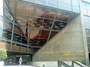
Institute of Aesthetic Research
Distance: Approx. 2188 meters
Latitude and longitude: 19.317,-99.1826
The Institute of Aesthetic Research (Spanish: Instituto de Investigaciones Estéticas) of the National Autonomous University of Mexico, since its foundation in 1936, research has been carried out in its installations into the different forms of artistic expression in Mexico; the diversity of studies undertaken by the body of researchers in the fields of criticism, theory and history of art across a horizon that reaches other latitudes. It has thus become a space where the plastic arts converge with dance, literature, photography, cinema and music. Every year, through its International Colloquium on Art History, the Institute opens its doors to academic reflection on the history of art.

Cuicuilco
Distance: Approx. 544 meters
Latitude and longitude: 19.30166667,-99.18166667
Cuicuilco is an important archaeological site located on the southern shore of Lake Texcoco in the southeastern Valley of Mexico, in what is today the borough of Tlalpan in Mexico City. Construction of the Cuicuilco pyramid began a few centuries BCE, during the Late Preclassic period of Mesoamerican history. The site was occupied until its destruction by the eruption of Xitle, sometime between 245 and 315 CE. Based on its date of occupation, Cuicuilco may be the oldest city in the Valley of Mexico and was roughly contemporary with, and possibly interacting with, the Olmecs of Mexico's Gulf Coast region (also known as the Olmec heartland).
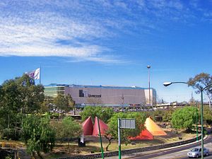
Perisur
Shopping mall in Mexico City, Mexico
Distance: Approx. 968 meters
Latitude and longitude: 19.30422,-99.18991
Perisur (also Centro Comercial Perisur) is a shopping mall located in the Coyoacán borough in southern Mexico City at the intersection of Insurgentes Avenue South and the Anillo Periférico, next to the UNAM main campus in Ciudad Universitaria and to the upscale Jardines del Pedregal neighbourhood. Designed by architect Juan Sordo Madaleno, the shopping center became the largest shopping mall in total area in Mexico when it opened in 1980.
National Library of Mexico
Distance: Approx. 2094 meters
Latitude and longitude: 19.3162,-99.1849
The National Library of Mexico (Spanish: Biblioteca Nacional de México) is located in Ciudad Universitaria, the main campus of the National Autonomous University of Mexico (UNAM) in Mexico City. It was first established on November 30, 1867. As a national library it is the preeminent bibliographic repository of Mexico and is subject to legal deposit.
Restaurante Arroyo
Restaurant in Mexico City, Mexico
Distance: Approx. 1428 meters
Latitude and longitude: 19.2875,-99.17555556
Restaurante Arroyo is the world's largest single Mexican restaurant, located in the Tlalpan area of Mexico City. The restaurant, which employs more than 1,000 people during its peak season, has seating for 2,200 patrons in nine dining rooms, and parking for 600 cars. It also features stages for musical performances, an array of wandering mariachi and jarocho bands, an infirmary, an area for hosting piñata parties, a cockfighting pit, a mechanical bull, and its own bullring.

Universidad Pontificia de México
Distance: Approx. 1886 meters
Latitude and longitude: 19.2881,-99.1692
The Universidad Pontificia de México (Pontifical University of Mexico) is a private institution of higher education originally established Charles I, King of Spain in 1551, re-established by the Holy See in 1982, and sponsored by the Roman Catholic Episcopate in Mexico. It is one of the two modern Mexican universities claiming to be successors of the Royal and Pontifical University of Mexico (Real y Pontificia Universidad de México) one of the first universities founded in North America. The university is today the only existing pontifical university in Mexico.

Fourteenth federal electoral district of Mexico City
Federal electoral district of Mexico
Distance: Approx. 1569 meters
Latitude and longitude: 19.28333333,-99.18333333
The fourteenth federal electoral district of Mexico City (Distrito electoral federal 14 de la Ciudad de México; previously "of the Federal District") is one of the 300 electoral districts into which Mexico is divided for elections to the federal Chamber of Deputies and one of the 22 currently operational districts in Mexico City. It elects one deputy to the lower house of Congress for each three-year legislative session by means of the first-past-the-post system. Votes cast in the district also count towards the calculation of proportional representation ("plurinominal") deputies elected from the fourth region.

National School of Anthropology and History
Distance: Approx. 787 meters
Latitude and longitude: 19.3029,-99.1795
National School of Anthropology and History (in Spanish: Escuela Nacional de Antropología e Historia, ENAH) is a Mexican Institution of higher education founded in 1938 and a prominent center for the study of Anthropology and History in the Americas. It is part of Mexico's National Institute of Anthropology and History (INAH) and offers bachelor's and postgraduate degrees in Anthropology and its disciplines: Linguistics, Social Anthropology, Ethnology, Archaeology, Physical Anthropology, Ethnohistory and History.
Fuentes Brotantes de Tlalpan National Park
National park in Mexico City, Mexico
Distance: Approx. 1421 meters
Latitude and longitude: 19.285,-99.181
Fuentes Brotantes de Tlalpan National Park is a national park located in the Tlalpan district of southern Mexico City. It was declared a National Park on 28 September 1936, on what was previously known as the Rancho Teochtíhuitl and the Barranca de los Manantiales.

Batman: The Ride (Six Flags México)
Roller coaster
Distance: Approx. 2356 meters
Latitude and longitude: 19.2952,-99.2065
Batman: The Ride is a steel inverted coaster at Six Flags Mexico that has been operating since 2000. It is a standard Vekoma Suspended Looping Coaster model themed to the famed Batman franchise, and was part of Premier Park's massive renovation in 2000.
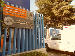
Instituto Nacional de Neurología y Neurocirugía
Hospital in Mexico City, Mexico
Distance: Approx. 1216 meters
Latitude and longitude: 19.29058056,-99.17516111
The National Institute of Neurology and Neurosurgery (Instituto Nacional de Neurología y Neurocirugía, or INNN) is a public hospital in Mexico City. The hospital has 126 beds for patients in neurosurgery, neurology, and psychiatry.
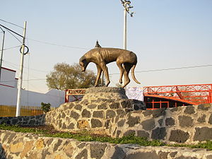
Monumento al perro callejero
Bronze sculpture in Mexico City
Distance: Approx. 1293 meters
Latitude and longitude: 19.29105556,-99.17388889
The Monumento al perro callejero (lit. transl. "Monument to the Stray Dog"), also known as Peluso, is an outdoor bronze sculpture installed along Insurgentes Sur Avenue, in the southern borough of Tlalpan, in Mexico City. The statue was unveiled in July 2008 and was dedicated to the free-ranging dogs of the city.
Weather in this IP's area
thunderstorm
20 Celsius
20 Celsius
20 Celsius
20 Celsius
1014 hPa
76 %
1014 hPa
780 hPa
9656 meters
2.06 m/s
330 degree
100 %
06:25:00
18:36:30