Country:
 Mexico
Region:
City:
Latitude and Longitude:
Time Zone:
Postal Code:
IP information under different IP Channel
ip-api
Country
Region
City
ASN
Time Zone
ISP
Blacklist
Proxy
Latitude
Longitude
Postal
Route
IPinfo
Country
Region
City
ASN
Time Zone
ISP
Blacklist
Proxy
Latitude
Longitude
Postal
Route
MaxMind
Country
Region
City
ASN
Time Zone
ISP
Blacklist
Proxy
Latitude
Longitude
Postal
Route
Luminati
Country
MXRegion
cmx
City
tlalpan
ASN
Time Zone
America/Mexico_City
ISP
UNINET
Latitude
Longitude
Postal
db-ip
Country
Region
City
ASN
Time Zone
ISP
Blacklist
Proxy
Latitude
Longitude
Postal
Route
ipdata
Country
Region
City
ASN
Time Zone
ISP
Blacklist
Proxy
Latitude
Longitude
Postal
Route
Popular places and events near this IP address

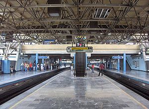
Xola metro station
Mexico City metro station
Distance: Approx. 77 meters
Latitude and longitude: 19.3952,-99.1377
Xola (Spanish pronunciation: [ʃo.la]) is a station on Line 2 of the Mexico City Metro system. It is located in the Colonia Moderna and Colonia Alamos districts of the Benito Juárez borough of Mexico City, directly south of the city centre on Calzada de Tlalpan. It is a surface station.
Viaducto metro station
Mexico City metro station
Distance: Approx. 694 meters
Latitude and longitude: 19.400808,-99.136891
Viaducto is a station on Line 2 of the Mexico City Metro system. It is located in the border of Benito Juárez and Iztacalco boroughs of Mexico City, south of the city centre on Calzada de Tlalpan. It is a surface station.
Chabacano metro station
Mexico City Metro station
Distance: Approx. 1634 meters
Latitude and longitude: 19.40916667,-99.13555556
Chabacano metro station is a Mexico City Metro transfer station in Cuauhtémoc, Mexico City. It is a combined underground and at-grade station with two side platforms and one island platform, featuring the Spanish solution layout. It serves Lines 2 (the Blue Line), 8 (the Green Line) and 9 (the Brown Line).

Villa de Cortés metro station
Mexico City metro station
Distance: Approx. 803 meters
Latitude and longitude: 19.38753,-99.138994
Villa de Cortés is a station on Line 2 of the Mexico City Metro system. It is located in the Benito Juárez borough of Mexico City, directly south of the city center on Calzada de Tlalpan. It is a surface station.

Nativitas metro station
Mexico City metro station
Distance: Approx. 1708 meters
Latitude and longitude: 19.379474,-99.140217
Nativitas is a station on Line 2 of the Mexico City Metro system. It is located in the Colonia Nativitas and Colonia Lago neighborhoods of Benito Juárez borough of Mexico City, directly south of the city centre on Calzada de Tlalpan. It is a surface station.

Lázaro Cárdenas metro station (Mexico City)
Mexico City metro station
Distance: Approx. 1534 meters
Latitude and longitude: 19.40696,-99.144874
Lázaro Cárdenas (Spanish: Estación Lázaro Cárdenas) is on Line 9 of the Mexico City Metro System between Metro Centro Médico and Metro Chabacano at the intersection of Eje Central and Eje 3 Sur. It links to the Eje Central Trolebus line.
Colonia Algarín
Neighborhood of Mexico City in Cuauhtémoc
Distance: Approx. 1148 meters
Latitude and longitude: 19.40499722,-99.13882222
Colonia Algarín is a very small working class residential neighborhood located south of the historic center of Mexico City. Its border to the north is Eje 3 Sur José Peón Contreras, to the south Viaducto Miguel Alemán, to the east San Antonio Abad Ave (Calzada de Tlalpan) and to the west Eje Central Lázaro Cárdenas. Colonia Algarín is located between colonias Buenos Aires (Eje Central), Álamos (Viaducto), Obrera (Eje 3 Sur) and Asturias (San Antonio Abad).
Colonia Ampliación Asturias
Distance: Approx. 1615 meters
Latitude and longitude: 19.40754722,-99.13105556
Colonia Ampliación Asturias is a neighborhood in the Cuauhtémoc borough of Mexico City. It is located southeast of the historic center of Mexico City. It borders are marked by the following streets, to the north Eje Tres Sur or Avenida Calzada del Chabacano, Calzada de la Viga to the east, Calzada de San Antonio Abad to the west and Hernandez Davalos street to the south.
Colonia Asturias
Neighborhood of Mexico City in Cuauhtémoc
Distance: Approx. 1197 meters
Latitude and longitude: 19.40467222,-99.13393056
Colonia Asturias is a colonia or neighborhood in the Cuauhtémoc borough, south of the historic center of Mexico City. It is a lower-class residential neighborhood, whose borders are formed by the following streets, Calles Hernández y Dávalos in the north, Viaducto Piedad in the south, Calzada de la Viga in the east and Calzada San Antonio Abad in the west.
Colonia Buenos Aires
Neighborhood of Mexico City in Cuauhtémoc
Distance: Approx. 1711 meters
Latitude and longitude: 19.40564444,-99.14963611
Colonia Buenos Aires is a colonia of the Cuauhtémoc borough located south of the historic center of Mexico City. This colonia is primarily known for its abundance of dealers selling used car parts, and an incident when six youths were executed by police. About half of the colonia's residents make a living from car parts, but these businesses have a reputation for selling stolen merchandise.

Colonia Vista Alegre
Neighborhood of Mexico City in Cuauhtémoc
Distance: Approx. 1814 meters
Latitude and longitude: 19.41025833,-99.13307222
Colonia Vista Alegre is a colonia in the Cuauhtémoc borough of Mexico City just south of the city's historic center. The boundaries of the colonia are formed by the following streets: Calzada de Chabacano to the south, José T. Cuellar to the north, Colonia Paulino Narvarro to the east and Calzada de Tlalpan to the west. The name, which translates to “Happy View,” derives from the view of what was then countryside which permitted views of the Popocatépetl and Iztaccíhuatl volcanos as well as the Sierra del Ajusco and Sierra de las Cruces mountains.
Viaducto Piedad
Distance: Approx. 781 meters
Latitude and longitude: 19.4,-99.13333333
Viaducto Piedad is a colonia in the Iztacalco borough of Mexico City, Mexico. Its name comes from Viaducto Miguel Alemán, a primary thoroughfare in Mexico City, and from the former De la Piedad River, which now runs in a culvert underneath the highway. It is served by the Viaducto metro station of the Mexico City Metro.
Weather in this IP's area
thunderstorm
20 Celsius
20 Celsius
20 Celsius
20 Celsius
1013 hPa
77 %
1013 hPa
785 hPa
9656 meters
2.06 m/s
330 degree
100 %
06:24:48
18:36:20