Country:
 Mexico
Region:
City:
Latitude and Longitude:
Time Zone:
Postal Code:
IP information under different IP Channel
ip-api
Country
Region
City
ASN
Time Zone
ISP
Blacklist
Proxy
Latitude
Longitude
Postal
Route
IPinfo
Country
Region
City
ASN
Time Zone
ISP
Blacklist
Proxy
Latitude
Longitude
Postal
Route
MaxMind
Country
Region
City
ASN
Time Zone
ISP
Blacklist
Proxy
Latitude
Longitude
Postal
Route
Luminati
Country
MXRegion
mex
City
toluca
ASN
Time Zone
America/Mexico_City
ISP
UNINET
Latitude
Longitude
Postal
db-ip
Country
Region
City
ASN
Time Zone
ISP
Blacklist
Proxy
Latitude
Longitude
Postal
Route
ipdata
Country
Region
City
ASN
Time Zone
ISP
Blacklist
Proxy
Latitude
Longitude
Postal
Route
Popular places and events near this IP address

State of Mexico
State of central Mexico
Distance: Approx. 4658 meters
Latitude and longitude: 19.35,-99.63333333
The State of Mexico (Spanish: Estado de México, pronounced [esˈtaðo ðe ˈmexiko] ), officially just Mexico (Spanish: México), is one of the 32 federal entities of Mexico. Commonly known as Edomex (from Estado de México) to distinguish it from the name of the whole country, it is the most populous, as well as the most densely populated, state in the country. Located in south-central Mexico, the state is divided into 125 municipalities.
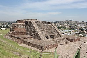
Calixtlahuaca
Archaeological site in Mexico
Distance: Approx. 7527 meters
Latitude and longitude: 19.33333333,-99.68333333
Calixtlahuaca (from the Nahuatl, where calli means "building", and ixtlahuatl means "prairie" or "plains", hence the translation would be "buildings on the plains"; Otomi: Ndähni, windy town, original Matlatzinca name: Pintanbati) is a Postclassic period Mesoamerican archaeological site, located near the present-day city of Toluca in the State of Mexico. Known originally as "Matlatzinco", this urban settlement was a powerful capital whose kings controlled a large territory in the Toluca Valley.

Toluca (meteorite)
Group of meteorites found in Mexico
Distance: Approx. 9263 meters
Latitude and longitude: 19.45,-99.58333333
Toluca is a group of iron meteorites found in Jiquipilco, Mexico near Toluca.

Circuito Centro Dinámico Pegaso
Motorsport venue in Mexico
Distance: Approx. 9618 meters
Latitude and longitude: 19.36722222,-99.55666667
Circuito Centro Dinámico Pegaso is a motorsport venue located in Toluca, Mexico. In 2016, the circuit met all FIA requirements and obtained homologation to host a round of the NACAM Formula 4 Championship, thus becoming an international track endorsed by FIA in the State of Mexico.
Weather in this IP's area
thunderstorm with light rain
15 Celsius
15 Celsius
15 Celsius
18 Celsius
1014 hPa
100 %
1014 hPa
752 hPa
4828 meters
3.09 m/s
320 degree
100 %
06:26:49
18:38:22