148.226.128.6 - IP Lookup: Free IP Address Lookup, Postal Code Lookup, IP Location Lookup, IP ASN, Public IP
Country:
Region:
City:
Location:
Time Zone:
Postal Code:
ISP:
ASN:
language:
User-Agent:
Proxy IP:
Blacklist:
IP information under different IP Channel
ip-api
Country
Region
City
ASN
Time Zone
ISP
Blacklist
Proxy
Latitude
Longitude
Postal
Route
db-ip
Country
Region
City
ASN
Time Zone
ISP
Blacklist
Proxy
Latitude
Longitude
Postal
Route
IPinfo
Country
Region
City
ASN
Time Zone
ISP
Blacklist
Proxy
Latitude
Longitude
Postal
Route
IP2Location
148.226.128.6Country
Region
veracruz de ignacio de la llave
City
jalapa enriquez
Time Zone
America/Mexico_City
ISP
Language
User-Agent
Latitude
Longitude
Postal
ipdata
Country
Region
City
ASN
Time Zone
ISP
Blacklist
Proxy
Latitude
Longitude
Postal
Route
Popular places and events near this IP address

Veracruz
State of Mexico
Distance: Approx. 885 meters
Latitude and longitude: 19.52722222,-96.9225
Veracruz, formally Veracruz de Ignacio de la Llave, officially the Free and Sovereign State of Veracruz de Ignacio de la Llave, is one of the 31 states which, along with Mexico City, comprise the 32 Federal Entities of Mexico. Located in eastern Mexico, Veracruz is bordered by seven states, which are Tamaulipas, San Luis Potosí, Hidalgo, Puebla, Oaxaca, Chiapas, and Tabasco. Veracruz is divided into 212 municipalities, and its capital city is Xalapa-Enríquez.

Xalapa
Municipality and city in Veracruz, Mexico
Distance: Approx. 1375 meters
Latitude and longitude: 19.54,-96.9275
Xalapa or Jalapa (English: , Spanish: [xaˈlapa] ), officially Xalapa-Enríquez (IPA: [xaˈlapa enˈrikes]), is the capital city of the Mexican state of Veracruz and the name of the surrounding municipality. In the 2020 census the city reported a population of 443,063 and the municipality of which it serves as municipal seat reported a population of 488,531. The municipality has an area of 118.45 km2.
Roman Catholic Archdiocese of Xalapa
Latin Catholic jurisdiction in Mexico
Distance: Approx. 1375 meters
Latitude and longitude: 19.54,-96.9275
The Archdiocese of Xalapa (Latin: Archidioecesis Ialapensis) is a Latin Church ecclesiastical territory or archdiocese of the Catholic Church in Mexico. Its episcopal see is Xalapa, Veracruz. A metropolitan see, its ecclesiastical province includes the suffragan dioceses of Coatzacoalcos, Córdoba, Orizaba, Papantla, San Andrés Tuxtla, Tuxpan and Veracruz.

Xalapa Cathedral
Church in Xalapa, Mexico
Distance: Approx. 886 meters
Latitude and longitude: 19.527688,-96.922994
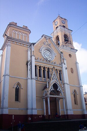
Xalapa Cathedral or in full, Catedral Metropolitana de la Inmaculada Concepción de Xalapa is a Roman Catholic cathedral in the city of Xalapa, Veracruz, in eastern Mexico. The see of the Metropolitan Archdiocese of Xalapa, it is one of the oldest constructions of the city. The cathedral was originally built in 1641, but in 1772 it underwent massive change that reconstructed it in the baroque style.

El Colegio de Veracruz
College in Xalapa, Veracruz, Mexico
Distance: Approx. 566 meters
Latitude and longitude: 19.5293,-96.9204
The El Colegio de Veracruz (Colver) is a college in the city of Xalapa, Veracruz, Mexico.
Universidad Metropolitana Xalapa
Distance: Approx. 978 meters
Latitude and longitude: 19.5349,-96.9258
The Universidad Metropolitana Xalapa is a university in the city of Xalapa, Veracruz, Mexico. This university offers 4 year degrees in several courses including: Business Administration, Public Accounting, International Business, Marketing, Industrial Relations, Law, Pedagogy, Architecture, English, and Tourism. Fall and Spring semester learning is available.

Paseo de los Lagos
Distance: Approx. 1655 meters
Latitude and longitude: 19.51888889,-96.92166667
Paseo de los Lagos is a lake and public path located in the city of Xalapa in Veracruz state in eastern Mexico. It was once the site of an ancient dam. The lake has a fresh-water spring and is surrounded by footpaths.

Xalapa Museum of Anthropology
Anthropological museum in Xalapa, Mexico
Distance: Approx. 2459 meters
Latitude and longitude: 19.5505,-96.931
The Xalapa Museum of Anthropology (Spanish: Museo de Antropología de Xalapa; MAX) is an anthropological museum in the city of Xalapa, capital of the state of Veracruz in eastern Mexico. It is known for its collection of artifacts from Mesoamerican Gulf Coast cultures such as the Olmec, Totonac, and Huastec, including several Olmec colossal heads. The museum's current building was opened in 1986.

Estadio Xalapeño
Distance: Approx. 1496 meters
Latitude and longitude: 19.51972222,-96.91888889
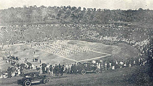
The Stadium at Xalapa, Veracruz, ("Estadio Xalapeño") is located a few blocks south and downhill of the center of town, and can be easily seen from the terraces of Parque Juárez. The place was identified in the 1920s by William K. Boone, then president of the local Chamber of Commerce, as a natural stadium similar to those of the classical stadiums and theaters of ancient Greece. The site had been a mosquito-infested marshland known as the "Ciénega de Melgarejo" that was drained and filled under the direction of the Chamber of Commerce, with manpower provided by the Jalapa Railroad and Power Company (JRR&PC).

Parque Juárez
Public park in Xalapa, Mexico
Distance: Approx. 1076 meters
Latitude and longitude: 19.52611111,-96.92388889
Parque Juárez is a public park in the city of Xalapa, in the state of Veracruz in eastern Mexico. It was inaugurated in 1892 and named in honor of Benito Juárez, 20 years after his death. The park is located in central Xalapa with a terrace-like appearance adjoining the Palacio de Gobierno building, across the street from the Palacio Municipal and close to the cathedral.
Parque Los Berros
Distance: Approx. 1045 meters
Latitude and longitude: 19.52361111,-96.91694444
Parque Los Berros, in Xalapa, Veracruz, is located a short distance to the southeast of the center of town, in the neighbourhood of the Stadium. Its name was derived from an edible herb called "berros" (garden cress) that used to grow in the area. Throughout the 19th century, the place would turn into a mosquito-infested marshland during the Summer rainy season.

10th federal electoral district of Veracruz
Federal electoral district of Mexico
Distance: Approx. 1745 meters
Latitude and longitude: 19.53333333,-96.93333333
The 10th federal electoral district of Veracruz (Distrito electoral federal 10 de Veracruz) is one of the 300 electoral districts into which Mexico is divided for elections to the federal Chamber of Deputies and one of 19 such districts in the state of Veracruz. It elects one deputy to the lower house of Congress for each three-year legislative session by means of the first-past-the-post system. Votes cast in the district also count towards the calculation of proportional representation ("plurinominal") deputies elected from the third region.
Weather in this IP's area
overcast clouds
11 Celsius
11 Celsius
11 Celsius
11 Celsius
1024 hPa
87 %
1024 hPa
855 hPa
10000 meters
2.35 m/s
4.09 m/s
326 degree
100 %
