Country:
Region:
City:
Latitude and Longitude:
Time Zone:
Postal Code:
IP information under different IP Channel
ip-api
Country
Region
City
ASN
Time Zone
ISP
Blacklist
Proxy
Latitude
Longitude
Postal
Route
Luminati
Country
Region
cmx
City
azcapotzalco
ASN
Time Zone
America/Mexico_City
ISP
Instituto Politecnico Nacional
Latitude
Longitude
Postal
IPinfo
Country
Region
City
ASN
Time Zone
ISP
Blacklist
Proxy
Latitude
Longitude
Postal
Route
db-ip
Country
Region
City
ASN
Time Zone
ISP
Blacklist
Proxy
Latitude
Longitude
Postal
Route
ipdata
Country
Region
City
ASN
Time Zone
ISP
Blacklist
Proxy
Latitude
Longitude
Postal
Route
Popular places and events near this IP address

La Raza metro station
Mexico City Metro station
Distance: Approx. 1504 meters
Latitude and longitude: 19.470153,-99.136891
La Raza metro station is a Mexico City Metro transfer station in Gustavo A. Madero, Mexico City. It is a combined underground and at-grade station with two side platforms. It serves Lines 3 (the Olive Line) and 5 (the Yellow Line).

Autobuses del Norte metro station
Mexico City Metro station
Distance: Approx. 1067 meters
Latitude and longitude: 19.478973,-99.140668
Autobuses del Norte metro station is a Mexico City Metro station in Gustavo A. Madero, Mexico City. It is an at-grade station with two side platforms, served by Line 5 (the Yellow Line), between Instituto del Petróleo and La Raza stations. Autobuses del Norte station serves the colonias (neighborhoods) of Ampliación Panamericana and Capultitlan.

Potrero metro station
Mexico City Metro station
Distance: Approx. 1889 meters
Latitude and longitude: 19.47691,-99.132171
Potrero metro station is a station of the Mexico City Metro along Avenida de los Insurgentes, in Gustavo A. Madero, Mexico City. It is an at-grade station with one island platform serving Line 3 (the Olive Line) between Deportivo 18 de Marzo and La Raza metro stations. Potrero metro station was inaugurated on 1 December 1979, providing northward service toward Indios Verdes and southward service toward Hospital General.

Instituto del Petróleo metro station
Mexico City Metro station
Distance: Approx. 1657 meters
Latitude and longitude: 19.489573,-99.14526
Instituto del Petróleo metro station is a Mexico City Metro transfer station in Gustavo A. Madero, Mexico City. It is a combined underground and at-grade station with two side platforms each, along Lines 5 (the Yellow Line) and 6 (the Red Line). Instituto del Petróleo metro station is located between Politécnico and Autobuses del Norte stations on Line 5, and between Vallejo and Lindavista stations on Line 6.

Vallejo metro station
Mexico City metro station
Distance: Approx. 1799 meters
Latitude and longitude: 19.490625,-99.15586
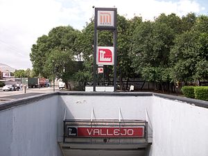
Vallejo (Spanish: Estación Vallejo) is a station along Line 6 of the Mexico City Metro. It is located in the Colonia Vallejo neighborhood of the Azcapotzalco borough of northwestern Mexico City. Its logo represents a silhouette of a factory.

Norte 45 metro station
Mexico City Metro station
Distance: Approx. 1989 meters
Latitude and longitude: 19.488683,-99.162769
Norte 45 (Spanish: Estación Norte 45) is a station on Line 6 of the Mexico City Metro. It is located in the Colonia Pueblo Salinas neighborhood. The logo for this station is a compass rose and the station takes its name from a nearby street that runs from northeast to southwest (somewhat unusual for streets in Mexico City that typically run either north–south or east–west).

Mexican Petroleum Institute
Distance: Approx. 1668 meters
Latitude and longitude: 19.489866,-99.145957
The Mexican Petroleum Institute (in Spanish: Instituto Mexicano del Petróleo, IMP) is a public research organization dedicated to develop technical solutions, conduct basic and applied research and provide specialized training to Pemex, the state-owned government-granted monopoly in Mexico's petroleum industry. The Institute was founded on 23 August 1965 by federal decree and is based in Mexico City. Despite facing significant budget constraints in recent years and being accused of depending excessively on foreign technology by noted physicist Leopoldo García-Colín, it was the leading patent applicant among Mexican institutions in 2005 and houses one of the most advanced microscopes on the planet.
Colonia Atlampa
Neighborhood of Mexico City in Cuauhtémoc
Distance: Approx. 2056 meters
Latitude and longitude: 19.457325,-99.15414444
Colonia Atlampa is a colonia or neighborhood located in the Cuauhtémoc borough, northwest of the historic center of Mexico City. The boundaries of the area are marked by the following streets: Calzada de Nonoalco or Ricardo Flores Magón Street to the south, Circuito Interior Paseo de las Jacarandas to the north, Avenida Insurgentes Norte to the east and Circuito Interior Instituto Politécnico Industrial to the west. The neighborhood is considered lower class and working class.
Colonia San Simón Tolnáhuac
Distance: Approx. 1968 meters
Latitude and longitude: 19.459025,-99.14302778
Colonia San Simón Tolnáhuac is a colonia in the Cuauhtémoc borough of Mexico City, just north of the city's historic center. The colonia's borders are marked by the following streets: Eje 1 Poniente to the south, Avenida Rio Consulado to the north, Lerdo Street and Calzada Vallejo to the east and Avenida de los Insurgentes Norte to the west. This area originally was part of the Tlatelolco dominion and functioned as communal farmland through most of the pre-Hispanic and colonial periods.
Colonia Santa María Insurgentes
Distance: Approx. 1625 meters
Latitude and longitude: 19.46080556,-99.14980833
Colonia Santa María Insurgentes is a colonia in the Cuauhtémoc borough north east of the Mexico City’s historic center. The colonia’s borders are formed by the following roads: Calzada de San Simon to the south, Jacarandas to the north, Avenida de los Insurgentes Norte to the east and Jacarandas to the west. The official establishment of the colonia occurred in 1910, but there had been named streets and laid out blocks for some time before this.

Monumento a la Raza (Mexico City)
Monument in Mexico City
Distance: Approx. 1457 meters
Latitude and longitude: 19.46444444,-99.1425
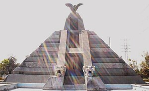
The Monumento a la Raza is a 50 meters (160 ft) high pyramid in northern Mexico City. It is located in the intersection of Avenida de los Insurgentes, Circuito Interior and Calzada Vallejo, in the Cuauhtémoc borough. The monument consists of three superimposed truncated pyramids decorated with several sculptures on the sides and an eagle on the tip.

2023 Mexico City Metro train crash
2023 railway accident in Mexico City
Distance: Approx. 1626 meters
Latitude and longitude: 19.47388889,-99.13469444
A train crash occurred on 7 January 2023 at 09:16 CDT (UTC−5) when a Mexico City Metro train going northward towards Indios Verdes metro station crashed into another one that was parked inside the Potrero–La Raza interstation tunnel of Line 3, which runs below Avenida de los Insurgentes. The collision killed one person and injured 106 others, including the driver of the train that crashed.
Weather in this IP's area
broken clouds
16 Celsius
15 Celsius
16 Celsius
17 Celsius
1012 hPa
72 %
1012 hPa
782 hPa
10000 meters
1.54 m/s
60 degree
75 %
06:39:38
18:00:46

