Country:
 USA
USARegion:
City:
Latitude and Longitude:
Time Zone:
Postal Code:
IP information under different IP Channel
ip-api
Country
Region
City
ASN
Time Zone
ISP
Blacklist
Proxy
Latitude
Longitude
Postal
Route
IPinfo
Country
Region
City
ASN
Time Zone
ISP
Blacklist
Proxy
Latitude
Longitude
Postal
Route
MaxMind
Country
Region
City
ASN
Time Zone
ISP
Blacklist
Proxy
Latitude
Longitude
Postal
Route
Luminati
Country
USASN
Time Zone
America/Chicago
ISP
SNC
Latitude
Longitude
Postal
db-ip
Country
Region
City
ASN
Time Zone
ISP
Blacklist
Proxy
Latitude
Longitude
Postal
Route
ipdata
Country
Region
City
ASN
Time Zone
ISP
Blacklist
Proxy
Latitude
Longitude
Postal
Route
Popular places and events near this IP address
Clallam County, Washington
County in Washington, United States
Distance: Approx. 961 meters
Latitude and longitude: 48.1125,-123.44083333
Clallam County is a county in the U.S. state of Washington. As of the 2020 census, the population was 77,155, with an estimated population of 77,805 in 2022. The county seat and largest city is Port Angeles; the county as a whole comprises the Port Angeles, WA Micropolitan Statistical Area.

Port Angeles, Washington
City in Washington, United States
Distance: Approx. 922 meters
Latitude and longitude: 48.11305556,-123.44083333
Port Angeles ( AN-jəl-əs) is a city and county seat of Clallam County, Washington, United States. With a population of 19,960 as of the 2020 census, it is the largest city in the county. The population was estimated at 20,134 in 2021.

Agnew, Washington
Unincorporated community in Washington, United States
Distance: Approx. 1407 meters
Latitude and longitude: 48.10611111,-123.425
Agnew is an unincorporated community in Clallam County, Washington, United States. It lies on a backroad leading to Port Angeles and just outside Sequim. Agnew is a primarily rural residential area located along the Strait of Juan de Fuca.
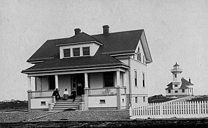
Ediz Hook Light
Lighthouse
Distance: Approx. 679 meters
Latitude and longitude: 48.11275,-123.4266
Ediz Hook Lighthouse was a lighthouse in Port Angeles, Washington, United States. Originally constructed in 1865, the lighthouse structure was later replaced in 1908 by a new structure, and finally in 1946 by an automated beacon on the United States Coast Guard air station on the end of Ediz Hook.

St. Andrew's Episcopal Church (Port Angeles, Washington)
Historic church in Washington, United States
Distance: Approx. 279 meters
Latitude and longitude: 48.11586,-123.42933
St. Andrew's Episcopal Church, also known as the Salvation Army Citidel Corps and now hosting the Salvation Army Corps Community Center, is a historic building located at 206 South Peabody Street, in Port Angeles, Washington. Originally a church, the structure was built in 1905 in Gothic Revival style.

Masonic Temple (Port Angeles, Washington)
United States historic place
Distance: Approx. 663 meters
Latitude and longitude: 48.11348,-123.43662
The Masonic Temple at 622 South Lincoln Street in Port Angeles, Washington is a historic masonic temple that was constructed in 1921 in Classical Revival style. Throughout the early 20th century, temple members included some of the city's most prominent citizens. The building also served as the primary facility in Port Angeles for large social and civic gatherings.

Naval Lodge Elks Building
United States historic place
Distance: Approx. 84 meters
Latitude and longitude: 48.1186,-123.43184
The Naval Lodge Elks Building, also known as Naval Lodge No. 353 BPOE Temple is a historic building located at 131 East First Street, Port Angeles, Washington. It was first envisioned on September 28, 1896 when the city leaders of Port Angeles, Washington met with members of the Navy to found Naval Lodge No.
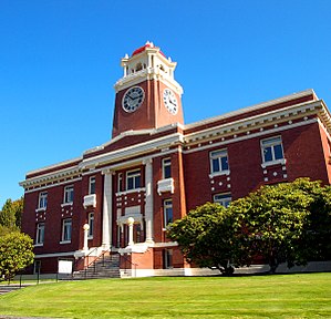
Clallam County Courthouse
United States historic place
Distance: Approx. 299 meters
Latitude and longitude: 48.1159,-123.4333
The Clallam County Courthouse is located at 319 Lincoln Street in Port Angeles, Washington. It was built in 1914 and 1915, replacing an older wood courthouse built in 1892, and officially dedicated on June 14, 1915. A 1979 expansion, connected to the historic courthouse by an enclosed bridge, now houses many of the official functions, including courts, public records, and a jail.

United States Post Office (Port Angeles, Washington)
United States historic place
Distance: Approx. 360 meters
Latitude and longitude: 48.11954,-123.43533
The U.S Post Office, also known as the Federal Building and the Old Post Office, is a historic building located at 138 West 1st Street in Port Angeles, Washington which was built in 1931–1933. A Post Office had been established in Port Angeles since 1860, but had no permanent home and moved several times. The land for the Post Office and Federal building was originally occupied by a squatter for whom the city raised funds to build a new house at a different location.

Olympic Medical Center
Hospital in Washington, United States
Distance: Approx. 1222 meters
Latitude and longitude: 48.11555556,-123.415
Olympic Medical Center is a medical organization located in Port Angeles and Sequim, Washington which provides services to patients in Clallam and Jefferson counties. The principal operating location is Olympic Memorial Hospital in Port Angeles. This location consists of 126 in-patient hospital beds and many other hospital services and has one of two Level III trauma centers in the state.

Joseph Paris House
United States historic place
Distance: Approx. 481 meters
Latitude and longitude: 48.11563,-123.43631
The Joseph Paris House, also known as the Airplane House and the Peace House is a historic wood frame bungalow built in 1920 and located at 101 East 5th Street in Port Angeles, Washington. Although being substantially a one-story building, an upper sleeping room rises from the center of the main roof, forming an airplane like configuration, whence the name of "Airplane House". The first owner of the house, Joseph Paris, was the owner of the Paris Motor Company in the city.

Olympic National Park Headquarters Historic District
Historic district in Washington, United States
Distance: Approx. 2044 meters
Latitude and longitude: 48.09977,-123.43252
The Olympic National Park Headquarters Historic District overlooks Port Angeles, Washington from Peabody Heights, consisting of 6 contributing buildings built in 1940–44, 8 contributing structures and 17 non-contributing properties that act as the administrative headquarters for Olympic National Park. The contributing structures were built using locally obtained native materials in a late interpretation of the National Park Service Rustic style. Native landscaping enhances the site.
Weather in this IP's area
broken clouds
7 Celsius
6 Celsius
6 Celsius
9 Celsius
1022 hPa
93 %
1022 hPa
1019 hPa
10000 meters
2.06 m/s
120 degree
75 %
07:38:19
18:18:51