Country:
Region:
City:
Latitude and Longitude:
Time Zone:
Postal Code:
IP information under different IP Channel
ip-api
Country
Region
City
ASN
Time Zone
ISP
Blacklist
Proxy
Latitude
Longitude
Postal
Route
Luminati
Country
Region
z
City
turan
ASN
Time Zone
Asia/Jerusalem
ISP
Tamares Telecom Ltd
Latitude
Longitude
Postal
IPinfo
Country
Region
City
ASN
Time Zone
ISP
Blacklist
Proxy
Latitude
Longitude
Postal
Route
db-ip
Country
Region
City
ASN
Time Zone
ISP
Blacklist
Proxy
Latitude
Longitude
Postal
Route
ipdata
Country
Region
City
ASN
Time Zone
ISP
Blacklist
Proxy
Latitude
Longitude
Postal
Route
Popular places and events near this IP address

Golani Interchange
Highway interchange in Israel
Distance: Approx. 4153 meters
Latitude and longitude: 32.77488889,35.40788889
Golani Interchange (Hebrew: מחלף גולני), known as Maskana Junction in Arabic, is a key road interchange in the Lower Galilee region of northern Israel, located east of Haifa and west of Tiberias, at the intersection of highways 65 and 77. The Golani Brigade Museum commemorating the Golani Brigade is situated there.
Kafr Kanna
Town in Northern District, Israel
Distance: Approx. 3487 meters
Latitude and longitude: 32.75,35.35
Kafr Kanna (Arabic: كفر كنا, Kafr Kanā; Hebrew: כַּפְר כַּנָּא) is an Arab town in the Galilee, part of the Northern District of Israel. It is associated by Christians with the New Testament village of Cana, where Jesus turned water into wine. In 2022 its population was 24,108.
Beit Rimon
Kibbutz in northern Israel
Distance: Approx. 3205 meters
Latitude and longitude: 32.78194444,35.32972222
Beit Rimon (Hebrew: בֵּית רִמּוֹן, lit. House of the Pomegranate) is a kibbutz located in the Lower Galilee Regional Council in Israel. It consists of a core kibbutz and a residential expansion.

Ilaniya
Place in Northern, Israel
Distance: Approx. 4254 meters
Latitude and longitude: 32.75833333,35.40194444
Ilaniya (Hebrew: אִילָנִיָּה) is a moshav in northern Israel. Also known as Sejera, after the adjacent Arab village al-Shajara, it was the first Jewish settlement in the Lower Galilee and played an important role in the Jewish settlement of the Galilee from its early years until the 1948 Arab–Israeli War. It falls under the jurisdiction of Lower Galilee Regional Council, and had a population of 476 in 2022.

Mitzpe Netofa
Place in Northern, Israel
Distance: Approx. 3268 meters
Latitude and longitude: 32.80277778,35.38444444
Mitzpe Netofa (Hebrew: מִצְפֵּה נְטוֹפָה) is a religious community settlement in northern Israel. Located adjacent to the Arab village Tur'an, it falls under the jurisdiction of the Lower Galilee Regional Council. In 2022 it had a population of 1,074.
Tur'an
Arab town in northern Israel
Distance: Approx. 1152 meters
Latitude and longitude: 32.77694444,35.37583333
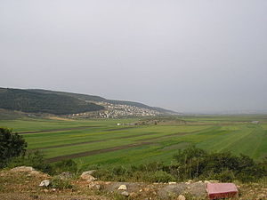
Tur'an (Arabic: طرعان, Hebrew: תֻּרְעָן) is an Arab local council in the Northern District of Israel. It is located at the foot of Mount Tur'an and the Tur'an Valley, near the main road from Haifa to Tiberias, and about 17 kilometres (11 mi) north of Nazareth. In 2022 it had a population of 14,809, most of whom are Israeli Arabs.

Bu'eine Nujeidat
Local council in Israel
Distance: Approx. 3178 meters
Latitude and longitude: 32.8075,35.36722222
Bu'eine Nujeidat (Hebrew: בועיינה-נוג'ידאת; Arabic: بعينة-نجيدات) is an Arab local council in the Northern District of Israel. Made up of two villages, Bu'eine and Nujeidat, they merged in 1987 and were recognized as one local council in 1996. In 2022 its population was 10,289, the majority of which is Muslim.

Uzeir
Place in Northern, Israel
Distance: Approx. 3414 meters
Latitude and longitude: 32.79222222,35.33083333
Uzeir (Arabic: عزير; Hebrew: עֻזֵיר) is an Arab village in northern Israel. Located near Nazareth Illit in the Lower Galilee, it falls under the jurisdiction of al-Batuf Regional Council. In 2022 it had a population of 3,511.

Al-Shajara, Palestine
Place in Tiberias, Mandatory Palestine
Distance: Approx. 4280 meters
Latitude and longitude: 32.75444444,35.39888889
Al-Shajara (Arabic: الشجرة) was a Palestinian Arab village depopulated by Israel during the 1948 Arab-Israeli War when its residents were forcefully evacuated and became refugees. It was located 14 kilometers west of Tiberias on the main highway to Nazareth near the villages of Lubya and Hittin. The village was very close to the city of Nazareth, about 5 kilometers away.
Murder of Oleg Shaichat
2003 kidnapping and attack in Israel
Distance: Approx. 2615 meters
Latitude and longitude: 32.7622,35.3444
The Murder of Oleg Shaichat was a kidnapping and murder attack which occurred on July 28, 2003, in which two members of the Arab-Israeli terrorist cell "Free People of the Galilee" abducted and murdered Israeli soldier Corporal Oleg Shaichat.

Wedding Church at Cana
Church in Kafr Kanna, Israel
Distance: Approx. 4310 meters
Latitude and longitude: 32.7467,35.3386
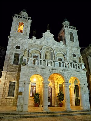
The Wedding Church at Cana (Arabic: كنيسة الزفاف في كنا; Hebrew: כנסיית החתונה) or simply Wedding Church, also Franciscan Wedding Church, is a religious building of the Catholic Church located in the central part of the town of Kafr Kanna (Cana), in Lower Galilee, located in northern Israel. It is dedicated to the weddings of Christianity. Its name commemorates the event of the Wedding at Cana from the Gospel of John, thought by some Christians to have taken place on the site, during which Jesus performed his first miracle, by turning water into wine at the request or behest of Mother Mary.

St. Bartholomew the Apostle Church, Kafr Kanna
Church in Kafr Kanna, Israel
Distance: Approx. 4251 meters
Latitude and longitude: 32.7475,35.3383
The St. Bartholomew the Apostle Church (Hebrew: כנסיית בית ברתולומאוס השליח Latin: Ecclesia Sancti Bartholomei Apostoli) is the name given to a Catholic church administered by the Franciscan order in Kafr Kanna in Israel, built in honor of Cana, the place where Scripture says was the hometown of the apostle St. Bartholomew.
Weather in this IP's area
light rain
15 Celsius
15 Celsius
15 Celsius
15 Celsius
1014 hPa
89 %
1014 hPa
972 hPa
10000 meters
1.77 m/s
1.9 m/s
234 degree
32 %
06:11:45
16:36:04
