147.194.53.122 - IP Lookup: Free IP Address Lookup, Postal Code Lookup, IP Location Lookup, IP ASN, Public IP
Country:
Region:
City:
Location:
Time Zone:
Postal Code:
IP information under different IP Channel
ip-api
Country
Region
City
ASN
Time Zone
ISP
Blacklist
Proxy
Latitude
Longitude
Postal
Route
Luminati
Country
Region
on
City
bolton
ASN
Time Zone
America/Toronto
ISP
COMWAVE-BGP-01
Latitude
Longitude
Postal
IPinfo
Country
Region
City
ASN
Time Zone
ISP
Blacklist
Proxy
Latitude
Longitude
Postal
Route
IP2Location
147.194.53.122Country
Region
ontario
City
toronto
Time Zone
America/Toronto
ISP
Language
User-Agent
Latitude
Longitude
Postal
db-ip
Country
Region
City
ASN
Time Zone
ISP
Blacklist
Proxy
Latitude
Longitude
Postal
Route
ipdata
Country
Region
City
ASN
Time Zone
ISP
Blacklist
Proxy
Latitude
Longitude
Postal
Route
Popular places and events near this IP address

York University
Public university in Toronto, Ontario, Canada
Distance: Approx. 1126 meters
Latitude and longitude: 43.77305556,-79.50361111
York University (French: Université York), also known as YorkU or simply YU, is a public research university in Toronto, Ontario, Canada. It is Canada's third-largest university, and it has approximately 53,500 students, 7,000 faculty and staff, and over 375,000 alumni worldwide. It has 11 faculties, including the Lassonde School of Engineering, Schulich School of Business, Osgoode Hall Law School, Glendon College, and 32 research centres.

Schulich School of Business
Canadian business school in Toronto
Distance: Approx. 788 meters
Latitude and longitude: 43.77305556,-79.49861111
The Schulich School of Business is the business school of York University located in Toronto, Ontario, Canada. The institution provides undergraduate and graduate degree and diploma programs in business administration, finance, accounting, business analytics, public administration and international business as well as a number of PhD and executive programs. Originally known as the Faculty of Administrative Studies (FAS), it was renamed in 1995 after Seymour Schulich, a major benefactor who has donated $15 million to the school.
York University GO Station
Railway station in Ontario, Canada
Distance: Approx. 630 meters
Latitude and longitude: 43.77883333,-79.48344444
York University GO Station was a train station on GO Transit's Barrie line, in the North York district of Toronto, Ontario, Canada. The station served York University but was located in an industrial area 1.6 km (1 mi) away from the York campus; it was connected by a shuttle bus service privately operated by the university. The station was only served on weekdays, southbound during the morning peak period and northbound during the afternoon peak period; its replacement, the nearby Downsview Park station, provides a connection from midday, evening, weekend, and holiday GO trains to the university at all times via a two-stop trip on the Toronto Transit Commission's (TTC) Line 1 subway.
CHRY-FM
Radio station in Toronto
Distance: Approx. 966 meters
Latitude and longitude: 43.77555556,-79.50277778
CHRY-FM (branded as VIBE 105) is a Canadian radio station in Toronto, Ontario. Broadcasting at 105.5 MHz, it has also served as a community radio station for the residents of the Jane and Finch corridor in North Toronto. CHRY is run by the Canadian Centre for Civic Media and Arts Development Inc., with the station's studios are located at York University's Student Centre, and its transmitter is located on top of the Vanier College residence building.

National Tennis Centre (Canada)
Sports facility in Toronto, which was demolished in 2003
Distance: Approx. 775 meters
Latitude and longitude: 43.779144,-79.500504
The original National Tennis Centre in Toronto was located in the north end of York University's Keele Campus next to the Metro Toronto Track and Field Centre. The first tournament at the facility was the 1976 Rothmans Canadian Open. Originally built with clay courts, it was changed to Har-Tru hardcourts in time for the 1979 tournament.

York University station
Toronto subway station
Distance: Approx. 791 meters
Latitude and longitude: 43.77416667,-79.49972222
York University is a subway station on Line 1 Yonge–University of the Toronto subway. It is located on the main Keele Campus of York University, near Ian Macdonald and York Boulevards in the former city of North York. It opened in 2017, as part of the extension of the subway to Vaughan Metropolitan Centre.

Toronto Track and Field Centre
Distance: Approx. 1295 meters
Latitude and longitude: 43.777492,-79.50721
The Toronto Track and Field Centre is a city-owned athletic training centre in Toronto, Ontario, Canada. Prior to 1998 it was called Metro Toronto Track and Field Centre. It is located at York University's Keele campus in the north-west section of the city.

Keele Campus
Main campus of York University in Toronto
Distance: Approx. 1127 meters
Latitude and longitude: 43.77306667,-79.50363056
The Keele Campus is the main campus of York University in the North York district of Toronto, Ontario, Canada. It occupies roughly 1 square kilometre of land and is situated between Jane Street to the west, Keele Street to the east, Steeles Avenue West to the north and Finch Avenue West to the south. It is the largest post-secondary campus in Canada at 457 acres (185 ha).
York University Busway
Bus transit right-of-way in Toronto, Canada
Distance: Approx. 1172 meters
Latitude and longitude: 43.7684,-79.484
The York University Busway is a bus-only roadway in Toronto, Ontario, Canada, which stretches 1.8 kilometres (1.1 mi) from Finch West subway station to Dufferin Street. It is used by the Toronto Transit Commission's 939B Finch Express bus route. The busway was constructed in 2009 as part of a series of bus-only roadways and bus lanes stretching 6.5 kilometres (4.0 mi) from Downsview station (now Sheppard West) to York University to serve the 196 York University Rocket bus rapid transit route.
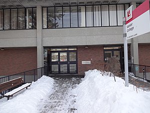
Vanier College at York University
Distance: Approx. 925 meters
Latitude and longitude: 43.77553333,-79.50224722
Vanier College, founded in 1966, was the second college to come into existence on the Keele Campus. The college is named after former Governor General of Canada Georges Vanier. The mandated academic areas which Vanier College supports are: Business and Society, Business Economics, Children’s Studies, Classical Studies & Classics, Culture and Expression, Economics, Financial and Business Economics, Hellenic Studies, Humanities, Individualized Studies, Jewish Studies, Liberal Studies, Philosophy, Religious Studies, Social and Political Thought as well as all Undecided Majors in the Faculty of Liberal Arts and Professional Studies.

York Lions Stadium
Outdoor sports venue in Toronto, Ontario
Distance: Approx. 1310 meters
Latitude and longitude: 43.775,-79.507
York Lions Stadium is an outdoor sports stadium on the Keele Campus of Toronto's York University in the former city of North York. It is home to the York Lions, the varsity teams of York University, the Toronto Arrows of Major League Rugby and York United of the Canadian Premier League. The facility was primarily built for the 2015 Pan American and Parapan American Games, where it hosted track and field events and the opening ceremony.

Improve Canada
Shopping mall in Ontario, Canada
Distance: Approx. 1201 meters
Latitude and longitude: 43.78727778,-79.49769444
Improve Canada is a commercial shopping mall complex located in Vaughan, Ontario, Canada. The mall has about 400 home improvement stores, exclusively focused on home improvement products and services.
Weather in this IP's area
overcast clouds
6 Celsius
1 Celsius
5 Celsius
7 Celsius
993 hPa
84 %
993 hPa
968 hPa
10000 meters
10.8 m/s
14.4 m/s
220 degree
100 %


