Country:
 Canada
Region:
City:
Latitude and Longitude:
Time Zone:
Postal Code:
IP information under different IP Channel
ip-api
Country
Region
City
ASN
Time Zone
ISP
Blacklist
Proxy
Latitude
Longitude
Postal
Route
IPinfo
Country
Region
City
ASN
Time Zone
ISP
Blacklist
Proxy
Latitude
Longitude
Postal
Route
MaxMind
Country
Region
City
ASN
Time Zone
ISP
Blacklist
Proxy
Latitude
Longitude
Postal
Route
Luminati
Country
CARegion
on
City
scarborough
ASN
Time Zone
America/Toronto
ISP
COMWAVE-BGP-01
Latitude
Longitude
Postal
db-ip
Country
Region
City
ASN
Time Zone
ISP
Blacklist
Proxy
Latitude
Longitude
Postal
Route
ipdata
Country
Region
City
ASN
Time Zone
ISP
Blacklist
Proxy
Latitude
Longitude
Postal
Route
Popular places and events near this IP address

Wexford, Toronto
Neighbourhood in Toronto, Ontario, Canada
Distance: Approx. 1195 meters
Latitude and longitude: 43.74305556,-79.30444444
Wexford is a neighbourhood in Toronto, Ontario, Canada. It is located in the eastern part of the city, on the western end of the district of Scarborough, spanning Lawrence Avenue East between Victoria Park Avenue and Birchmount Road. There are many persons of Greek heritage in this neighbourhood.
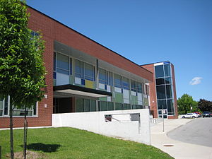
Senator O'Connor College School
High school in North York, Toronto, Ontario, Canada
Distance: Approx. 875 meters
Latitude and longitude: 43.750677,-79.317303
Senator O'Connor College School (also called SOCS, Senator O'Connor CS, Senator O'Connor, OCS, or simply Senator or O'Connor), previously known as John J. Lynch High School until 1967 is a Separate high school in the Parkwoods neighbourhood in the North York district of Toronto, Ontario, Canada serving grades 9 to 12 in the communities of Wexford, Maryvale, Don Mills, and Dorset Park. The school was named after Senator Frank O'Connor, founder of the Laura Secord chocolate company. The school is part of the Toronto Catholic District School Board and was originally founded as John J. Lynch High School in 1963, named after the first archbishop of Toronto from 1870 to 1888, John Joseph Lynch.

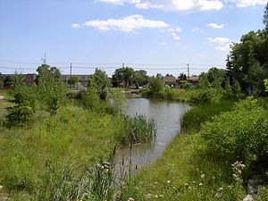
Parkwoods
Neighbourhood in Toronto, Ontario, Canada
Distance: Approx. 1303 meters
Latitude and longitude: 43.751,-79.323
Parkwoods or sometimes referred to as Parkwoods-Donalda, is a neighbourhood in Toronto, Ontario, Canada. It is a geographically large neighbourhood located just south of Ontario Highway 401, west of Victoria Park Avenue, north of Lawrence Avenue East and east of the Don Valley Parkway.

Dorset Park
Neighbourhood in Toronto, Ontario, Canada
Distance: Approx. 2027 meters
Latitude and longitude: 43.754,-79.282
Dorset Park is a neighbourhood in Toronto, Ontario, Canada. It is located in the western part of the district of Scarborough. The neighbourhood is bordered by Highway 401 to the north, Midland Avenue to the east, Lawrence Avenue to the south, and Birchmount Road to the west.

Bond Education Group
Canadian operator of private schools
Distance: Approx. 1540 meters
Latitude and longitude: 43.756944,-79.288611
Bond Education Group operates several private schools in Toronto, Ontario. It was established in 1978 and as of 2015, located at 1500 Birchmount Road in Scarborough, originally the former factory of Laura Secord Chocolates. Bond Education Group consists of the following schools: Bond Academy; a co-educational, non-denominational independent school with classes for pre-school children up to grade 12.

Wexford Collegiate School for the Arts
Public high school in Wexford, Toronto, Ontario, Canada
Distance: Approx. 851 meters
Latitude and longitude: 43.745972,-79.306601
Wexford Collegiate School for the Arts (commonly known as Wexford Collegiate, WCSA, Wexford CSA, Wexford or "Wex" for short), formerly and still known as Wexford Collegiate Institute (WCI) (initially known as Northwest Collegiate Institute) is a public high school in Toronto, Ontario, Canada. Located in the former suburb of Scarborough, it is run and organized by the Toronto District School Board. The school officially opened to students in September 1965 by the Scarborough Board of Education.

Victoria Park Collegiate Institute
Public school in Toronto, Ontario, Canada
Distance: Approx. 1171 meters
Latitude and longitude: 43.755768,-79.321445
Victoria Park Collegiate Institute (commonly known as Victoria Park C.I., Victoria Park, Vic Park, VP, and VPCI); formerly Victoria Park Secondary School, is a collegiate institute in Toronto, Ontario, Canada. It is located south of York Mills Road and west of Victoria Park Ave. in the district of North York.
Maryvale, Toronto
Neighbourhood in Toronto, Ontario, Canada
Distance: Approx. 1195 meters
Latitude and longitude: 43.74305556,-79.30444444
Maryvale is a neighbourhood in Toronto, Ontario, Canada. It is located on the western edge of the Scarborough district, with its western border being Victoria Park Avenue. To the north it is bordered by Highway 401, to the east by Warden and to the south by railroad tracks.
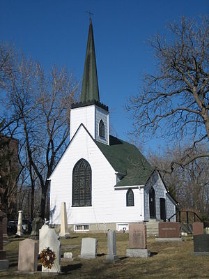
Church of St. Jude (Wexford)
Church in Ontario, Canada
Distance: Approx. 1658 meters
Latitude and longitude: 43.73873,-79.30595
The Church of St. Jude is an historic church in the Scarborough area of Toronto, Ontario, Canada. St.
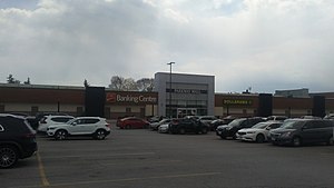
Parkway Mall
Shopping mall
Distance: Approx. 557 meters
Latitude and longitude: 43.75724,-79.31196
Parkway Mall (originally Parkway Plaza) is a community-scale shopping centre in Toronto, Ontario, Canada. It is located at the southeast corner of Victoria Park Avenue and Ellesmere Road in the Maryvale neighbourhood in the Scarborough district. Parkway Mall is more geared toward providing essential community and neighbourhood-level retail stores and services, rather than being a large-scale regional shopping destination, such as the nearby Fairview or Scarborough Town Centre.
Crestwood Preparatory College
Private school in Toronto, Ontario, Canada
Distance: Approx. 1554 meters
Latitude and longitude: 43.7592,-79.3249
Crestwood Preparatory College is a co-ed, non-semestered high school in Toronto, Ontario. Located in the former Brookbanks Public School property, Crestwood Preparatory College is owned by Toronto Lands Corporation (a real estate arm of the Toronto District School Board).
Toronto eSchool
Ontario secondary school - ossd online school
Distance: Approx. 1694 meters
Latitude and longitude: 43.76751,-79.29866
Toronto eSchool is an online high school and tutoring centre located in Toronto, Ontario, Canada. Toronto eSchool is inspected and approved by the Ontario Ministry of Education (BSID # 886520) to grant Ontario high school credits and the Ontario Secondary School Diploma (OSSD) itself since 2013. The tutoring centre offers both traditional tutoring and Maximize Your Success programs offered via seminars/webinars, workshops, academic programs, and test preparation classes.
Weather in this IP's area
clear sky
19 Celsius
19 Celsius
17 Celsius
21 Celsius
1017 hPa
82 %
1017 hPa
997 hPa
10000 meters
3.6 m/s
60 degree
07:00:28
19:22:04