Country:
 Canada
Region:
City:
Latitude and Longitude:
Time Zone:
Postal Code:
IP information under different IP Channel
ip-api
Country
Region
City
ASN
Time Zone
ISP
Blacklist
Proxy
Latitude
Longitude
Postal
Route
IPinfo
Country
Region
City
ASN
Time Zone
ISP
Blacklist
Proxy
Latitude
Longitude
Postal
Route
MaxMind
Country
Region
City
ASN
Time Zone
ISP
Blacklist
Proxy
Latitude
Longitude
Postal
Route
Luminati
Country
CARegion
on
City
scarborough
ASN
Time Zone
America/Toronto
ISP
COMWAVE-BGP-01
Latitude
Longitude
Postal
db-ip
Country
Region
City
ASN
Time Zone
ISP
Blacklist
Proxy
Latitude
Longitude
Postal
Route
ipdata
Country
Region
City
ASN
Time Zone
ISP
Blacklist
Proxy
Latitude
Longitude
Postal
Route
Popular places and events near this IP address

Scarborough—Guildwood (federal electoral district)
Federal electoral district in Ontario, Canada
Distance: Approx. 803 meters
Latitude and longitude: 43.763,-79.207
Scarborough—Guildwood is a federal electoral district in Toronto, Ontario, Canada, that has been represented in the House of Commons of Canada since 2004. It was created in 2003 from parts of Scarborough East, Scarborough Southwest and Scarborough Centre. This riding lost territory to Scarborough—Rouge Park and Scarborough Southwest, and gained territory from Scarborough Centre during the 2012 electoral redistribution.

Woburn Collegiate Institute
Public secondary school in Toronto, Ontario, Canada
Distance: Approx. 1573 meters
Latitude and longitude: 43.77777778,-79.22833333
Woburn Collegiate Institute is a semestered, English-language public secondary school on Ellesmere Road in the Woburn neighbourhood of the Scarborough district of Toronto, Ontario, Canada operated by the Toronto District School Board. From its inception in 1963 until 1998, it was operated by the Scarborough Board of Education. It has 919 students as of September 2019.

Cedarbrae Collegiate Institute
Public high school in Toronto, Ontario, Canada
Distance: Approx. 1595 meters
Latitude and longitude: 43.75638889,-79.22583333
Cedarbrae Collegiate Institute (CCI or Cedarbrae CI), formerly Cedarbrae Secondary School is a semestered public secondary school in Toronto, Ontario, Canada. It is located in the Woburn neighbourhood in former suburb of Scarborough. It was established in 1961 by the former Scarborough Board of Education and is now operated by the Toronto District School Board.

Woburn, Toronto
Neighbourhood in Toronto, Ontario, Canada
Distance: Approx. 1102 meters
Latitude and longitude: 43.76666667,-79.22777778
Woburn is a neighbourhood located in eastern Toronto, Ontario, Canada, in the former suburb of Scarborough. Woburn is bordered by Highway 401 to the north, Orton Park Road to the east, Lawrence Avenue to the south, and McCowan Road to the west. Residences are split between high rises and single detached homes, which account for almost ninety per cent of all residences.

Centenary Hospital
Hospital in Toronto, Ontario
Distance: Approx. 1538 meters
Latitude and longitude: 43.78,-79.20472222
Centenary Hospital is a hospital in Scarborough, Toronto, Ontario, Canada. It was opened on July 1, 1967, and was named in honour of the 100th anniversary of Canada. Since 2016, the hospital is operated by the Scarborough Health Network.
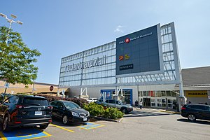
Cedarbrae Mall
Shopping mall in Ontario, Canada
Distance: Approx. 1629 meters
Latitude and longitude: 43.758,-79.229
Cedarbrae Mall is a shopping mall in Toronto, Ontario, Canada. It is located at the corner of Markham Road and Lawrence Avenue East in the Scarborough district. In terms of size, Cedarbrae Mall may be the eighty-ninth largest shopping mall in Canada with a floor area of 548,000 sq ft (50,911 m2).
West Highland Creek
River in Ontario, Canada
Distance: Approx. 1429 meters
Latitude and longitude: 43.77416667,-79.19861111
West Highland Creek is a river in Toronto, Ontario, Canada, and is a tributary of Highland Creek in the Lake Ontario drainage basin. The creek and its tributaries are entirely within the old City of Scarborough, and provide the watershed for the northwest of the city.

Morningside Park (Toronto)
Park in Toronto, Ontario
Distance: Approx. 1787 meters
Latitude and longitude: 43.779,-79.198
Morningside Park is a recreational nature park located in Scarborough, Toronto, Ontario, Canada. It is Toronto's largest municipal park by area.
Mariyah Islamic School
Distance: Approx. 1000 meters
Latitude and longitude: 43.76027778,-79.22055556
Mariyah Islamic School is an all-girls school located in Toronto, Canada. It is located at Central Mosque Scarborough. The school is recognized and accredited by the Ontario Ministry of Education, was first opened in 1995 and is known as the "sister" of Jaamiah Ajax, a boarding school exclusively for boys.
Scarboro Golf and Country Club
Golf club in Toronto, Ontario, Canada
Distance: Approx. 1604 meters
Latitude and longitude: 43.7537,-79.2118
The Scarboro Golf and Country Club is a private club in eastern Toronto, Ontario, Canada, located in the former city of Scarborough. Until 2018, it had facilities for curling and has an 18-hole golf course that is ranked among the top courses in Canada. The club was founded in 1912 by stockbroker A.E. Ames.
Scarborough—Guildwood (provincial electoral district)
Provincial electoral district in Ontario, Canada
Distance: Approx. 803 meters
Latitude and longitude: 43.763,-79.207
Scarborough—Guildwood is a provincial electoral district in the Scarborough section of Toronto, Ontario, Canada, that has been represented in Legislative Assembly of Ontario since the 2007 provincial election. It was created in 2003 from parts of Scarborough East, Scarborough Southwest and Scarborough Centre.

Maplewood High School (Toronto)
Vocational school in West Hill, Toronto, Ontario, Canada
Distance: Approx. 1854 meters
Latitude and longitude: 43.7601,-79.1939
Maplewood High School (locally known as Maplewood HS, MHS, or Maplewood), formerly Maplewood Vocational School is a specialized public vocational high school managed by the Scarborough Board of Education when it was passed on to the Toronto District School Board upon amalgamation in 1998. The school was founded in 1967 as the second junior vocational school in the former City of Scarborough. The school offers basic academic and vocational courses with graduates entering post-secondary programs such as college or employment.
Weather in this IP's area
overcast clouds
19 Celsius
19 Celsius
17 Celsius
21 Celsius
1017 hPa
82 %
1017 hPa
1000 hPa
10000 meters
2.07 m/s
3.7 m/s
52 degree
99 %
07:00:05
19:21:42