147.189.167.67 - IP Lookup: Free IP Address Lookup, Postal Code Lookup, IP Location Lookup, IP ASN, Public IP
Country:
Region:
City:
Location:
Time Zone:
Postal Code:
ISP:
ASN:
language:
User-Agent:
Proxy IP:
Blacklist:
IP information under different IP Channel
ip-api
Country
Region
City
ASN
Time Zone
ISP
Blacklist
Proxy
Latitude
Longitude
Postal
Route
db-ip
Country
Region
City
ASN
Time Zone
ISP
Blacklist
Proxy
Latitude
Longitude
Postal
Route
IPinfo
Country
Region
City
ASN
Time Zone
ISP
Blacklist
Proxy
Latitude
Longitude
Postal
Route
IP2Location
147.189.167.67Country
Region
michigan
City
gibraltar
Time Zone
America/Detroit
ISP
Language
User-Agent
Latitude
Longitude
Postal
ipdata
Country
Region
City
ASN
Time Zone
ISP
Blacklist
Proxy
Latitude
Longitude
Postal
Route
Popular places and events near this IP address

Gibraltar, Michigan
City in Michigan, United States
Distance: Approx. 740 meters
Latitude and longitude: 42.09138889,-83.19722222
Gibraltar is a city in Wayne County in the U.S. state of Michigan. The population was 4,656 at the 2010 census. Gibraltar is a southern city of Metro Detroit and is about 12 miles (19.3 km) south of the city of Detroit.
Battle of Brownstown
Skirmish in the War of 1812
Distance: Approx. 785 meters
Latitude and longitude: 42.094417,-83.1991678
The Battle of Brownstown was an early skirmish in the War of 1812. Although the United States military outnumbered the forces of Tecumseh's Confederacy 8 to 1, they lost the battle and suffered substantial losses while Tecumseh's forces were almost completely untouched. The battle occurred near Brownstown, a Wyandot village south of Fort Detroit on Brownstown creek.

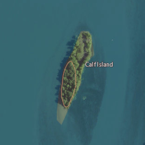
Calf Island (Michigan)
Island in Michigan, United States
Distance: Approx. 1249 meters
Latitude and longitude: 42.10305556,-83.17916667
Calf Island is an island in the Detroit River, in Michigan. It has a surface elevation of 571 feet (174 m). It is located in the Trenton Channel about 1,000 feet (304 m) west of the southern tip of Grosse Ile and Swan Island, and Hamburg Island is just to the northwest.

South Pointe Drive–Frenchman's Creek Bridge
United States historic place
Distance: Approx. 1668 meters
Latitude and longitude: 42.1025,-83.17222222
The South Pointe Drive–Frenchman's Creek Bridge is a bridge located on South Pointe Drive over Frenchman's Creek in Grosse Ile, Michigan. It was listed on the National Register of Historic Places in 2000.

Gibraltar Road–Waterway Canal Bridge
United States historic place
Distance: Approx. 71 meters
Latitude and longitude: 42.095,-83.19055556
The Gibraltar Road–Waterway Canal Bridge is a bridge located on Gibraltar Road over the Waterway Canal in Gibraltar, Michigan. It was listed on the National Register of Historic Places in 2000.
Humbug Marsh
Distance: Approx. 2322 meters
Latitude and longitude: 42.11583333,-83.18833333
Humbug Marsh, a 1.88 square kilometres (0.73 sq mi) wetland in southeastern Wayne County, Michigan, is a constituent element of the Detroit River International Wildlife Refuge. It is listed as a Ramsar wetland of international importance. Although Humbug Marsh is located within heavily populated Metro Detroit, it is acclaimed as a high-quality remnant of the wetlands that once lined both sides of the international Detroit River.

Celeron Island
Island in Michigan
Distance: Approx. 2173 meters
Latitude and longitude: 42.07972222,-83.17333333
Celeron Island is an island in the Detroit River. It is in Wayne County, in southeast Michigan, and the southernmost island within Grosse Ile Township. Its coordinates are 42°04′47″N 83°10′24″W, and the United States Geological Survey gave its elevation as 571 ft (174 m) in 1980.

Cherry Island (Michigan)
Island in Michigan
Distance: Approx. 1661 meters
Latitude and longitude: 42.08055556,-83.19472222
Cherry Island is an island in the Detroit River, in southeast Michigan. It is in Wayne County. Its coordinates are 42°04′50″N 83°11′41″W; the United States Geological Survey gave its elevation as 574 ft (175 m) in 1980.

Horse Island (Michigan)
Island in Michigan
Distance: Approx. 1504 meters
Latitude and longitude: 42.08194444,-83.185
Horse Island is an island in the Detroit River, in southeast Michigan. It is in Wayne County. Its coordinates are 42°04′55″N 83°11′06″W, and the United States Geological Survey gave its elevation as 571 ft (174 m) in 1980.

Edmond Island
Island in Michigan
Distance: Approx. 1410 meters
Latitude and longitude: 42.08277778,-83.19416667
Edmond Island is an island in the Detroit River located in the city of Gibraltar, Michigan, in the United States. Its coordinates are 42°04′58″N 83°11′39″W, and the United States Geological Survey gives its elevation as 577 ft (176 m).

Round Island (Detroit River)
Island in Michigan
Distance: Approx. 1882 meters
Latitude and longitude: 42.09222222,-83.16722222
Round Island is an island in the Detroit River in southeast Michigan. It is part of Grosse Ile Township, in Wayne County. Its coordinates are 42°05′32″N 83°10′02″W, and the United States Geological Survey gave its elevation as 581 ft (177 m) in 1980.

Swan Island (Michigan)
Island in Michigan
Distance: Approx. 1364 meters
Latitude and longitude: 42.09916667,-83.17416667
Swan Island is an island in the Detroit River. It is in Wayne County, in southeast Michigan. Its coordinates are 42°05′57″N 83°10′27″W, and the United States Geological Survey gave its elevation as 581 ft (177 m) in 1980.
Weather in this IP's area
clear sky
-19 Celsius
-26 Celsius
-19 Celsius
-18 Celsius
1034 hPa
68 %
1034 hPa
1009 hPa
10000 meters
4.63 m/s
240 degree