147.160.0.20 - IP Lookup: Free IP Address Lookup, Postal Code Lookup, IP Location Lookup, IP ASN, Public IP
Country:
Region:
City:
Location:
Time Zone:
Postal Code:
ISP:
ASN:
language:
User-Agent:
Proxy IP:
Blacklist:
IP information under different IP Channel
ip-api
Country
Region
City
ASN
Time Zone
ISP
Blacklist
Proxy
Latitude
Longitude
Postal
Route
db-ip
Country
Region
City
ASN
Time Zone
ISP
Blacklist
Proxy
Latitude
Longitude
Postal
Route
IPinfo
Country
Region
City
ASN
Time Zone
ISP
Blacklist
Proxy
Latitude
Longitude
Postal
Route
IP2Location
147.160.0.20Country
Region
pennsylvania
City
kittanning
Time Zone
America/New_York
ISP
Language
User-Agent
Latitude
Longitude
Postal
ipdata
Country
Region
City
ASN
Time Zone
ISP
Blacklist
Proxy
Latitude
Longitude
Postal
Route
Popular places and events near this IP address

Applewold, Pennsylvania
Borough in Pennsylvania, United States
Distance: Approx. 1265 meters
Latitude and longitude: 40.80861111,-79.52222222
Applewold is a borough in Armstrong County, Pennsylvania, United States. The population was 334 at the 2020 census.

Kittanning, Pennsylvania
Borough in Pennsylvania, United States
Distance: Approx. 434 meters
Latitude and longitude: 40.82,-79.52138889
Kittanning ( ki-TAN-ing) is a borough in and the county seat of Armstrong County, Pennsylvania, United States. It is situated 36 miles (58 km) northeast of Pittsburgh, along the east bank of the Allegheny River. The population was 3,921 at the 2020 census.

Manorville, Pennsylvania
Borough in Pennsylvania, United States
Distance: Approx. 3708 meters
Latitude and longitude: 40.78638889,-79.52166667
Manorville is a borough in Armstrong County, Pennsylvania, United States. The population was 382 at the 2020 census.

West Hills, Pennsylvania
Census-designated place in Pennsylvania, United States
Distance: Approx. 1478 meters
Latitude and longitude: 40.82444444,-79.54277778
West Hills is a census-designated place (CDP) in Armstrong County, Pennsylvania, United States. The population was 1,228 at the 2020 census.

West Kittanning, Pennsylvania
Borough in Pennsylvania, United States
Distance: Approx. 862 meters
Latitude and longitude: 40.81222222,-79.53
West Kittanning is a borough in Armstrong County, Pennsylvania, United States. The population was 1,192 at the 2020 census.
WKFO
Radio station in Kittanning, Pennsylvania
Distance: Approx. 3508 meters
Latitude and longitude: 40.78861111,-79.53472222
WKFO (1380 AM) is a 24-hour commercially licensed radio station with a maximum power output of 1,000 watts, non-directional. The station, licensed to the county seat of Kittanning, Pennsylvania is wholly owned by Matthew Lightner, through licensee Lightner Communications, based in Blair County, Pennsylvania. Studios, offices and transmitter facilities are located on Bunker Hill Road, in North Buffalo Township, Pennsylvania.
Kittanning Citizens Bridge
Bridge in Kittanning and West Kittanning, Pennsylvania
Distance: Approx. 846 meters
Latitude and longitude: 40.8125,-79.5226
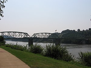
The Kittanning Citizens Bridge is a through truss bridge spanning the Allegheny River at Kittanning in the U.S. state of Pennsylvania. Constructed in 1932, the bridge carries vehicles and pedestrians between Kittanning and West Kittanning. The bridge is 949 feet (289 m) in length and has three main spans.
Cowanshannock Creek
River in the United States
Distance: Approx. 3861 meters
Latitude and longitude: 40.8511753,-79.5078224
Cowanshannock Creek (the eastern section is sometimes referred to as the North Branch Cowanshannock Creek) is a tributary of the Allegheny River in Armstrong and Indiana counties, Pennsylvania in the United States.

Judge J. Frank Graff Bridge
Bridge in Manor Township and North Buffalo Township
Distance: Approx. 2650 meters
Latitude and longitude: 40.79652,-79.51829
The Judge J. Frank Graff Bridge is an American truss bridge that carries U.S. Route 422 (US 422) and Pennsylvania Route 28 (PA 28) across the Allegheny River. It was named in honor of Frank Graff, an Armstrong County Court of Common Pleas Judge who later rose to become a member of the Pennsylvania Superior Court.

Armstrong County Courthouse and Jail
United States historic place
Distance: Approx. 898 meters
Latitude and longitude: 40.81638889,-79.51666667
Armstrong County Courthouse and Jail is a historic courthouse complex located at Kittanning, Armstrong County, Pennsylvania. The courthouse was built between 1858 and 1860, and is a two-story, brick and stone building measuring 105 feet by 65 feet. It has a hipped roof topped by an octagonal cupola and bell.

Allegheny River Lock and Dam No. 7
United States historic place
Distance: Approx. 270 meters
Latitude and longitude: 40.82111111,-79.52888889
Allegheny River Lock and Dam No. 7 is a historic lock and fixed-crest dam complex located at East Franklin Township, Pennsylvania and Kittanning in Armstrong County, Pennsylvania. It was built between 1928 and 1930 by the United States Army Corps of Engineers, and consists of the lock, dam, esplanade, and Operations Building.
Gosford, Pennsylvania
Unincorporated community in Pennsylvania, United States
Distance: Approx. 3640 meters
Latitude and longitude: 40.84972222,-79.51
Gosford is an unincorporated community in Rayburn Township, Armstrong County, Pennsylvania, United States. The community is situated approximately 3 miles (4.8 km) northeast of Kittanning at the place where Cowanshannock Creek joins the Allegheny River.
Weather in this IP's area
overcast clouds
1 Celsius
-3 Celsius
0 Celsius
1 Celsius
1024 hPa
54 %
1024 hPa
978 hPa
10000 meters
3.58 m/s
5.81 m/s
185 degree
100 %
