Country:
 Italy
ItalyRegion:
City:
Latitude and Longitude:
Time Zone:
Postal Code:
IP information under different IP Channel
ip-api
Country
Region
City
ASN
Time Zone
ISP
Blacklist
Proxy
Latitude
Longitude
Postal
Route
IPinfo
Country
Region
City
ASN
Time Zone
ISP
Blacklist
Proxy
Latitude
Longitude
Postal
Route
MaxMind
Country
Region
City
ASN
Time Zone
ISP
Blacklist
Proxy
Latitude
Longitude
Postal
Route
Luminati
Country
ITRegion
45
City
reggioemilia
ASN
Time Zone
Europe/Rome
ISP
Retelit Digital Services S.p.A.
Latitude
Longitude
Postal
db-ip
Country
Region
City
ASN
Time Zone
ISP
Blacklist
Proxy
Latitude
Longitude
Postal
Route
ipdata
Country
Region
City
ASN
Time Zone
ISP
Blacklist
Proxy
Latitude
Longitude
Postal
Route
Popular places and events near this IP address
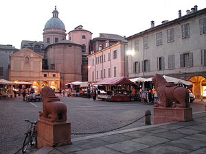
Reggio Emilia
City in Emilia-Romagna, Italy
Distance: Approx. 322 meters
Latitude and longitude: 44.7,10.63333333
Reggio nell'Emilia (Emilian: Rèz; Latin: Regium Lepidi), usually referred to as Reggio Emilia, or simply Reggio by its inhabitants, and known until 1861 as Reggio di Lombardia, is a city in northern Italy, in the Emilia-Romagna region. It has about 171,944 inhabitants and is the main comune (municipality) of the province of Reggio Emilia.The inhabitants of Reggio nell'Emilia are called Reggiani, while the inhabitants of Reggio di Calabria, in the southwest of the country, are called Reggini. The old town has a hexagonal form, which derives from the ancient walls, and the main buildings are from the 16th–17th centuries.

Sala del Tricolore
Distance: Approx. 322 meters
Latitude and longitude: 44.7,10.63333333
The Sala del Tricolore (lit. 'Room of the Tricolor'), formerly the Patriotic Hall, is an historical hall that currently serves as the council chamber of the comune (municipality) of Reggio Emilia, northern Italy. It was designed by the architect Lodovico Bolognini as the archive of the ducal family of Este. In the Sala del Tricolore, on 7 January 1797, the flag of Italy (also known as "the Tricolor") was born, hence the name of the hall.

Teatro Municipale (Reggio Emilia)
Distance: Approx. 133 meters
Latitude and longitude: 44.70111111,10.63138889
The Teatro Municipale (also since the 1980s called the Teatro Municipale Valli due to being named after the actor Romolo Valli) is a theatre in Reggio Emilia, Northern Italy. Following the destruction by fire of the 1741 Teatro Cittadella in April 1851, the new theatre was designed by the architect Cesare Costa and constructed in the neoclassical style between 1852 and 1857. Its inauguration took place on 21 April 1857 with the performance of the Vittor Pisani by local composer Achille Peri.

Roman Catholic Diocese of Reggio Emilia–Guastalla
Roman Catholic diocese in Italy
Distance: Approx. 320 meters
Latitude and longitude: 44.7,10.6333
The Diocese of Reggio Emilia–Guastalla (Latin: Dioecesis Regiensis in Aemilia–Guastallensis) is a Latin diocese of the Catholic Church in Emilia-Romagna, Italy. It has existed in its current form since 1986. In that year the historical Diocese of Reggio Emilia was united with the Diocese of Guastalla.
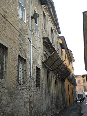
Palazzo Cassoli
Distance: Approx. 436 meters
Latitude and longitude: 44.69922,10.63428
Palazzo Cassoli is a historical building located in the centre of Reggio Emilia, central Italy. In the 16th century, the building belonged to the Boccacci family, who sold it in 1607 to count Girolamo Cassoli. At the end of the 17th century the façade was redone with a weave of leaves made of lime and pozzolana; the windows and the portal were adapted too.

Monument to the Fallen, Reggio Emilia
War memorial in Reggio Emilia, Italy
Distance: Approx. 162 meters
Latitude and longitude: 44.70081,10.63011
The Monument to the Fallen (Italian: Monumento ai Caduti) is a Fascist-era monument, dedicated to the Italians who died during the First World War (1915–1918), and located in central Reggio Emilia, at the south border of the Parco del Popolo (also called the Giardino Publico), at the border with Piazza della Vittoria and just west of the town's Opera House.

Monument to Antonio Fontanesi, Parco del Populo, Reggio Emilia
Distance: Approx. 110 meters
Latitude and longitude: 44.70195,10.63205
The Monument to Antonio Fontanesi is located the east side of the Parco del Popolo (Giardini Pubblici) in central Reggio Emilia, region of Emilia-Romagna, Italy. The monument is located near Viale Leopoldo Nobili. In the park, there is a distinct Bust of Antonio Fontanesi, sculpted by Marino Mazzacurati and donated to the city in 1937 by Anna e Luigi Parmeggiani.

Palazzo Busetti
Distance: Approx. 394 meters
Latitude and longitude: 44.69867,10.63113
The Palazzo Busetti or Bussetti, is a Baroque-style palace with a main facade located on Piazza del Monte 6, but structures connected with the palace are flanked by the via Francesco Crispi and Don Giuseppe Andreoli, in the historic center of the town of Reggio Emilia in Italy. The main palace facade faces the side of the Palazzo del Capitano del Popolo and the Palazzo del Monte di Pieta. The original palace was begun in 1657 by Count Ferdinando Busetti, who had gained a fortune in the commerce of silk.

Palazzo del Capitano del Popolo, Reggio Emilia
Distance: Approx. 417 meters
Latitude and longitude: 44.69847,10.6312
The Palazzo del Capitano del Popolo (Palace of the Captain of the People) is a Gothic-style civic building located facing the piazza del Monte in the historic center of the town of Reggio Emilia in Italy. The structure was erected in 1280 as the home and office of the town captain, who was required to be a foreigner representing the Lords of the Duchy. This position was abrogated in 1326.

Monument to the Concordi, Reggio Emilia
Italian landmark
Distance: Approx. 75 meters
Latitude and longitude: 44.70246,10.63157
The Monument to the Concordi Family is a monumental tomb likely erected presumably in the third quarter of the first century at a necropolis near the present town of Brescello near the ancient Roman town of Brixellum. Discovered in 1929, it was re-erected a year later in the Public Garden in central Reggio Emilia, Italy.
Oratory of San Spiridione
Distance: Approx. 398 meters
Latitude and longitude: 44.70068,10.62615
The Oratory of San Spiridione is a small Baroque-style church or chapel located on Via Nuova in the historic center of Reggio Emilia, region of Emilia Romagna, Italy.

Synagogue of Reggio Emilia
Synagogue in Reggio Emilia, Italy
Distance: Approx. 306 meters
Latitude and longitude: 44.69994,10.62849
The Synagogue of Reggio Emilia or the Sinagoga di Reggio Emilia is located on the Via dell'Aquila of Reggio Emilia, in the region of Emilia Romagna, in Italy. living in the Grand Duchy of Tuscany in 1848.
Weather in this IP's area
light rain
24 Celsius
25 Celsius
23 Celsius
24 Celsius
1013 hPa
87 %
1013 hPa
1007 hPa
10000 meters
1.64 m/s
1.3 m/s
299 degree
99 %
06:48:29
19:42:01