Country:
 France
Region:
City:
Latitude and Longitude:
Time Zone:
Postal Code:
IP information under different IP Channel
ip-api
Country
Region
City
ASN
Time Zone
ISP
Blacklist
Proxy
Latitude
Longitude
Postal
Route
Luminati
Country
FRRegion
ara
City
romanssurisere
ASN
Time Zone
Europe/Paris
ISP
ADISTA SAS
Latitude
Longitude
Postal
IPinfo
Country
Region
City
ASN
Time Zone
ISP
Blacklist
Proxy
Latitude
Longitude
Postal
Route
db-ip
Country
Region
City
ASN
Time Zone
ISP
Blacklist
Proxy
Latitude
Longitude
Postal
Route
ipdata
Country
Region
City
ASN
Time Zone
ISP
Blacklist
Proxy
Latitude
Longitude
Postal
Route
Popular places and events near this IP address

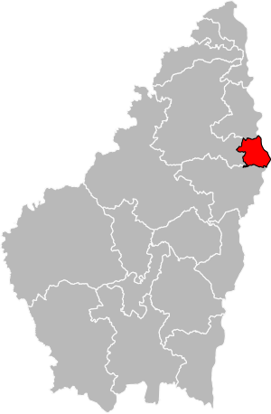
Arrondissement of Valence
Arrondissement in Auvergne-Rhône-Alpes, France
Distance: Approx. 1093 meters
Latitude and longitude: 44.92305556,4.88666667
The arrondissement of Valence is an arrondissement of France in the Drôme department in the Auvergne-Rhône-Alpes region. It has 101 communes. Its population is 292,801 (2016), and its area is 1,516.3 km2 (585.4 sq mi).

Roman Catholic Diocese of Valence
Catholic diocese in France
Distance: Approx. 554 meters
Latitude and longitude: 44.93,4.89
The Diocese of Valence (–Die–Saint-Paul-Trois-Châteaux) (Latin: Dioecesis Valentinensis (–Diensis–Sancti Pauli Tricastinorum); French: Diocèse de Valence (–Die–Saint-Paul-Trois-Châteaux) is a Latin Church diocese of the Catholic Church in southern France. The contemporary diocese is co-extensive with the department of Drôme.
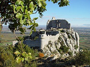
Château de Crussol
Distance: Approx. 2568 meters
Latitude and longitude: 44.93833333,4.8525
The Château de Crussol is a mostly-ruined 12th century limestone castle in the commune of Saint-Péray that dominates the valley of Rhône, just opposite Valence in the Ardèche département, Rhône-Alpes région of France.

Valence Cathedral
Distance: Approx. 437 meters
Latitude and longitude: 44.93166667,4.88944444
Valence Cathedral (French: Cathédrale Saint-Apollinaire de Valence) is a Roman Catholic church in Valence, Drôme, France. The cathedral is in the Romanesque architectural tradition. It is dedicated to Saint Apollinaris of Valence.

Guilherand-Granges
Commune in Auvergne-Rhône-Alpes, France
Distance: Approx. 730 meters
Latitude and longitude: 44.9353,4.8756
Guilherand-Granges (French pronunciation: [ɡijʁɑ̃ ɡʁɑ̃ʒ]; Vivaro-Alpine: Guilharand e las Granjas, before 1991: Guilherand) is a commune in the Ardèche department in southern France. It is a suburb of Valence, Drôme. It is one of the most populous commune in the Ardéche department, after Annonay and Aubenas, and before Tournon-sur-Rhône.
Bourg-lès-Valence
Commune in Auvergne-Rhône-Alpes, France
Distance: Approx. 2007 meters
Latitude and longitude: 44.9486,4.8961
Bourg-lès-Valence (French pronunciation: [buʁ lɛ valɑ̃s]; Occitan: Lo Borg de Valença) is a commune in the Drôme department in southeastern France. It is a suburb of Valence. The archaeologist and Hellenist Fernand Courby (1878–1932) was born in Bourg-lès-Valence.

Valence-Ville station
Distance: Approx. 857 meters
Latitude and longitude: 44.92805556,4.89277778
Valence-Ville station (French: Gare de Valence-Ville) is a railway station serving the town Valence, Drôme department, southeastern France. It is situated on the Paris–Marseille railway, and is the southern terminus of a branch line to Grenoble. The station is owned and operated by the SNCF and served by both TGV and TER Auvergne-Rhône-Alpes trains.

2007 Monte Carlo Rally
Distance: Approx. 603 meters
Latitude and longitude: 44.9333,4.8917
The 2007 Monte Carlo Rally (formally known as the 75e Rallye Automobile Monte-Carlo) was a rallying autosports race held over four days between 18 January and 21 January 2007, and operated out of Valence, Drôme, France. It was the first race of the 2007 World Rally Championship (WRC) season. Contested over fifteen stages at a length of 328.54 kilometres (204.15 miles), Sébastien Loeb won the race for the Citroën Total World Rally Team.
Canton of Guilherand-Granges
Canton in Auvergne-Rhône-Alpes, France
Distance: Approx. 1151 meters
Latitude and longitude: 44.93,4.87
The canton of Guilherand-Granges is an administrative division of the Ardèche department in southern France. It was created at the French canton reorganisation which came into effect in March 2015. Its seat is in Guilherand-Granges.
Canton of Valence-3
Distance: Approx. 2548 meters
Latitude and longitude: 44.91,4.88
The canton of Valence-3 is an administrative division of the Drôme department, southeastern France. Its borders were modified at the French canton reorganisation which came into effect in March 2015. Its seat is in Valence.
Canton of Valence-4
Distance: Approx. 554 meters
Latitude and longitude: 44.93,4.89
The canton of Valence-4 is an administrative division of the Drôme department, southeastern France. Its borders were modified at the French canton reorganisation which came into effect in March 2015. Its seat is in Valence.

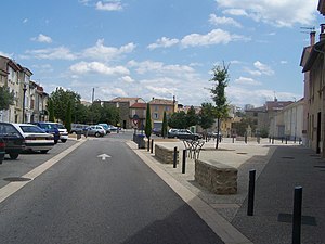
Valence, Drôme
Prefecture and commune in Auvergne-Rhône-Alpes, France
Distance: Approx. 603 meters
Latitude and longitude: 44.9333,4.8917
Valence (US: , French: [valɑ̃s] ; Occitan: Valença [vaˈlensɔ]) is a commune in southeastern France, the prefecture of the Drôme department and within the Auvergne-Rhône-Alpes region. It is situated on the left bank of the Rhône, about 100 kilometres (62 mi) south of Lyon, along the railway line that runs from Paris to Marseille. It is the eighth-largest city in the region by its population and has 64,726 registered inhabitants in 2018 (132,556 inhabitants in the urban area (unité urbaine).
Weather in this IP's area
overcast clouds
9 Celsius
8 Celsius
9 Celsius
9 Celsius
1019 hPa
93 %
1019 hPa
1006 hPa
10000 meters
2.06 m/s
30 degree
100 %
07:41:07
17:10:08