146.177.20.147 - IP Lookup: Free IP Address Lookup, Postal Code Lookup, IP Location Lookup, IP ASN, Public IP
Country:
Region:
City:
Location:
Time Zone:
Postal Code:
ISP:
ASN:
language:
User-Agent:
Proxy IP:
Blacklist:
IP information under different IP Channel
ip-api
Country
Region
City
ASN
Time Zone
ISP
Blacklist
Proxy
Latitude
Longitude
Postal
Route
db-ip
Country
Region
City
ASN
Time Zone
ISP
Blacklist
Proxy
Latitude
Longitude
Postal
Route
IPinfo
Country
Region
City
ASN
Time Zone
ISP
Blacklist
Proxy
Latitude
Longitude
Postal
Route
IP2Location
146.177.20.147Country
Region
england
City
huyton
Time Zone
Europe/London
ISP
Language
User-Agent
Latitude
Longitude
Postal
ipdata
Country
Region
City
ASN
Time Zone
ISP
Blacklist
Proxy
Latitude
Longitude
Postal
Route
Popular places and events near this IP address

Huyton
Town in England
Distance: Approx. 78 meters
Latitude and longitude: 53.41111111,-2.84027778
Huyton ( HY-tən) is a town in the Metropolitan Borough of Knowsley, Merseyside, England. Part of the Liverpool Built-up Area, it borders the Liverpool suburbs of Dovecot, Knotty Ash and Netherley. Historically in Lancashire, Huyton was an ancient parish which in the mid-19th century contained Croxteth Park, Knowsley and Tarbock.
Roby, Merseyside
Village in England
Distance: Approx. 859 meters
Latitude and longitude: 53.413,-2.852
Roby is a village and electoral ward in the Metropolitan Borough of Knowsley, Merseyside, England. Part of the wider built-up-area of Huyton-with-Roby with Huyton, Roby is effectively a dormitory village or suburb of the adjacent City of Liverpool. At the 2021 Census, the population of Roby electoral ward was 9,353.

Roby railway station
Railway station in Roby, Merseyside, England
Distance: Approx. 1121 meters
Latitude and longitude: 53.41,-2.856
Roby railway station serves the village of Roby, Merseyside, England. It is located 5 miles (8.0 km) east of Liverpool Lime Street on the former Liverpool and Manchester Railway, and 1⁄2 mile (800 m) west of Huyton. It is operated by Northern Trains, as part of Merseytravel's electrified City Line to Manchester and Wigan North Western.

Huyton railway station
Railway station in Merseyside, England
Distance: Approx. 297 meters
Latitude and longitude: 53.41,-2.843
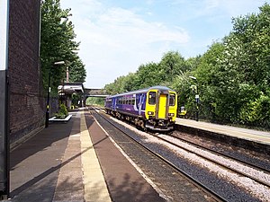
Huyton railway station serves Huyton in Merseyside, England. The station is an interchange between the Liverpool-Wigan Line and the northern route of the Liverpool-Manchester Line which diverge soon after the station. It is one of the busier stations on the lines and close to the shopping centre and bus station.
Huyton with Roby Urban District
Historic former administration area in north-west England
Distance: Approx. 252 meters
Latitude and longitude: 53.412,-2.843
Huyton with Roby Urban District was a local government district in Lancashire, England from 1894 to 1974. It consisted of the civil parish of Huyton with Roby which comprised the settlements of Huyton and Roby. It replaced the Huyton with Roby urban sanitary district.
Knowsley Community College
Further education college in Borough of Knowsley, Merseyside, England
Distance: Approx. 804 meters
Latitude and longitude: 53.413194,-2.851077
Knowsley Community College is a further education college based over three sites in the Metropolitan Borough of Knowsley, in Merseyside, England.
Huyton Quarry railway station
Former railway station in England
Distance: Approx. 1058 meters
Latitude and longitude: 53.4108,-2.8234
Huyton Quarry railway station opened in 1830 as part of the Liverpool and Manchester Railway, but Holt suggests it was originally known as the "station at the bottom of Whiston Incline" being renamed Huyton Quarry sometime after 1838. Either way it was one of the earliest passenger railway stations in the world. The station was closed by BR on 15 September 1958.
Huyton Hill Preparatory School
Distance: Approx. 406 meters
Latitude and longitude: 53.41221667,-2.83330278
Huyton Hill Preparatory School was a school for boys ages 8 to 13 focused on preparation for entering a Public School, open from 1926 to 1969. The school is one of several that were evacuated from cities in England at the outbreak of World War II to escape the risk of German bombs. It was known for a progressive, liberal approach to discipline.
St Thomas Becket Catholic High School
School in Liverpool, Merseyside, England
Distance: Approx. 965 meters
Latitude and longitude: 53.415,-2.826
St Thomas Becket Catholic High School was a Roman Catholic secondary school located in the Huyton area of Liverpool. In its final year, the school had only 90 pupils and 32 members of staff. It closed in July 2008.
Lord Derby Academy
Academy in Huyton, Merseyside, England
Distance: Approx. 581 meters
Latitude and longitude: 53.41232,-2.83066
Lord Derby Academy (LDA) is a coeducational secondary school founded in the mid-20th century. It has an academy status and is located in Huyton in the English county of Merseyside. Previously known as Knowsley Hey High School, in 2009 the school was merged with Bowring Comprehensive School to form Huyton Sports and Arts Centre for Learning (HASCEL) on the same site as the original building and the school was completely rebuilt under the Building Schools for the Future programme.

Knowsley Heights fire
1991 fire in Merseyside, England
Distance: Approx. 1177 meters
Latitude and longitude: 53.4217,-2.844
The Knowsley Heights fire occurred on 5 April 1991 at the 11-story Knowsley Heights tower block in Huyton, Merseyside. No-one was injured in the fire.

Huyton Municipal Building
Municipal building in Huyton, Merseyside, England
Distance: Approx. 94 meters
Latitude and longitude: 53.4116,-2.8407
Huyton Municipal Building is a municipal building in Archway Road, Huyton, a town in Merseyside, England. The building currently serves as the headquarters of Knowsley Metropolitan Borough Council.
Weather in this IP's area
broken clouds
7 Celsius
4 Celsius
6 Celsius
8 Celsius
974 hPa
91 %
974 hPa
970 hPa
10000 meters
4.12 m/s
80 degree
75 %
