Country:
Region:
City:
Latitude and Longitude:
Time Zone:
Postal Code:
IP information under different IP Channel
ip-api
Country
Region
City
ASN
Time Zone
ISP
Blacklist
Proxy
Latitude
Longitude
Postal
Route
Luminati
Country
Region
cl
City
arroyodelaencomienda
ASN
Time Zone
Europe/Madrid
ISP
Orange Espagne SA
Latitude
Longitude
Postal
IPinfo
Country
Region
City
ASN
Time Zone
ISP
Blacklist
Proxy
Latitude
Longitude
Postal
Route
db-ip
Country
Region
City
ASN
Time Zone
ISP
Blacklist
Proxy
Latitude
Longitude
Postal
Route
ipdata
Country
Region
City
ASN
Time Zone
ISP
Blacklist
Proxy
Latitude
Longitude
Postal
Route
Popular places and events near this IP address

Simancas
Municipality in Castile and León, Spain
Distance: Approx. 3130 meters
Latitude and longitude: 41.59191667,-4.82863889
Simancas is a town and municipality of central Spain, located in the province of Valladolid, part of the autonomous community of Castile and León. It is situated approximately 10 km southwest of the provincial capital Valladolid, on the road to Zamora and the right bank of the river Pisuerga. Simancas originated as the Roman Septimanca.

Battle of Simancas
Battle of the Reconquista in 939 AD
Distance: Approx. 1846 meters
Latitude and longitude: 41.6,-4.817
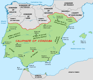
The Battle of Simancas (also called Alhandega or al-Khandaq) was a military battle that started on 19 July 939 in the Iberian Peninsula between the troops of the King of León Ramiro II and Cordovan caliph Abd al-Rahman III near the walls of the city of Simancas. The battle unfolded after the army of Abd al-Rahman III launched toward the northern Christian territories in 934. Abd al-Rahman III had gathered a large army of caliphal fighters, with the help of the Andalusian governor of Zaragoza, Muhammad ibn Yahya al-Tujibi.
Pabellón Polideportivo Pisuerga
Distance: Approx. 5121 meters
Latitude and longitude: 41.63138889,-4.74472222
Pabellón Polideportivo Pisuerga is an arena in Valladolid, Spain. It can hold 6,800 people. It is primarily used for basketball and the home arena of CB Valladolid, who moved into it from the Polideportivo Huerta del Rey in 1985.

Arroyo de la Encomienda
Place in Castile and León, Spain
Distance: Approx. 2942 meters
Latitude and longitude: 41.6253,-4.7714
Arroyo de la Encomienda is a municipality located in the province of Valladolid, Castile and León, Spain. According to the 2015 census (INE), the municipality has a population of 18491 inhabitants.

Ciguñuela
Place in Castile and León, Spain
Distance: Approx. 5303 meters
Latitude and longitude: 41.63333333,-4.85
Ciguñuela is a municipality located in the province of Valladolid, Castile and León, Spain. According to the 2010 census (INE), the municipality has a population of 396 inhabitants.

Archivo General de Simancas
Cultural property in Simancas, Spain
Distance: Approx. 3146 meters
Latitude and longitude: 41.59194444,-4.82888889
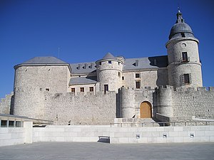
The General Archive of Simancas (Spanish: Archivo General de Simancas, also known by its acronym, AGS) is an official archive located in the Castle of Simancas, in the town of Simancas, province of Valladolid, Castile and León, Spain. It was founded in 1540, making this the first official archive of the Crown of Castile. The chronological evolution of the institution has been influenced by the history of the Crown of Castile.

Covaresa
Neighborhood of Valladolid, Spain
Distance: Approx. 3878 meters
Latitude and longitude: 41.61055556,-4.75055556
Covaresa is a neighborhood of Valladolid, located at the south of the city, with a population of about 8,700. It is bordered by railways to the east, Paula López and Parque Alameda to the north, El Peral to the west, and the South External Round of Valladolid. It was developed in the 1980s and it was not completed until nearly 2008, being one of the youngest zones in the city.

Valladolid Science Museum
Distance: Approx. 5477 meters
Latitude and longitude: 41.63777778,-4.74555556
Valladolid Science Museum (Spanish: Museo de la Ciencia de Valladolid) was opened in May 2003 as a museum and an iconic piece of architecture based on an old flour mill. Rafael Moneo and Enrique de Teresa used a lot of the old industrial complex to create this new Science Museum.

Monastery of Nuestra Señora del Prado
Historic site in Valladolid, Spain
Distance: Approx. 5679 meters
Latitude and longitude: 41.640858,-4.74585
The Monastery of Nuestra Señora del Prado (Spanish: Monasterio de Nuestra Señora del Prado) is a monastery located in the city of Valladolid, Spain. It was declared Bien de Interés Cultural in 1877.
Ciudad Deportiva del Real Valladolid
Distance: Approx. 5018 meters
Latitude and longitude: 41.64444444,-4.76333333
The Ciudad Deportiva del Real Valladolid, commonly known as Campos Anexos al Estadio José Zorrilla, is the training ground and academy base of the Spanish football club Real Valladolid. It was opened in 1988. Located few metres west of the Estadio José Zorrilla, it is used for youth and senior teams trainings.
University of Agricultural Engineering
Distance: Approx. 466 meters
Latitude and longitude: 41.60413333,-4.79282778
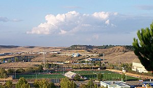
University of Agricultural Engineering, Valladolid, is a university run by the Society of Jesus which began in 1964 as the Nevares Institute of Agricultural Employers (INEA). It is currently affiliated with the University of Valladolid.

Castle of Simancas
Building in Castile and León, Spain
Distance: Approx. 3146 meters
Latitude and longitude: 41.59194444,-4.82888889
The Castle of Simancas (also known as Simancas Castle) is a fortified complex in Simancas, central Spain. The castle stands in the center of town and houses the current Archivo General de Simancas.
Weather in this IP's area
scattered clouds
17 Celsius
17 Celsius
17 Celsius
18 Celsius
1019 hPa
57 %
1019 hPa
940 hPa
10000 meters
1.54 m/s
320 degree
40 %
07:59:59
18:05:59

