Country:
Region:
City:
Latitude and Longitude:
Time Zone:
Postal Code:
IP information under different IP Channel
ip-api
Country
Region
City
ASN
Time Zone
ISP
Blacklist
Proxy
Latitude
Longitude
Postal
Route
Luminati
Country
ASN
Time Zone
America/Chicago
ISP
CISCO-UMBRELLA
Latitude
Longitude
Postal
IPinfo
Country
Region
City
ASN
Time Zone
ISP
Blacklist
Proxy
Latitude
Longitude
Postal
Route
db-ip
Country
Region
City
ASN
Time Zone
ISP
Blacklist
Proxy
Latitude
Longitude
Postal
Route
ipdata
Country
Region
City
ASN
Time Zone
ISP
Blacklist
Proxy
Latitude
Longitude
Postal
Route
Popular places and events near this IP address

South Dublin
County in Ireland
Distance: Approx. 2190 meters
Latitude and longitude: 53.30777778,-6.41305556
South Dublin (Irish: Átha Cliath Theas) is a county in Ireland, within the province of Leinster and the Eastern and Midland Region. It is one of three successor counties to County Dublin, which was disestablished for administrative purposes in 1994. South Dublin County Council is the local authority for the county.
Adamstown, Dublin
Western suburb of Dublin, Ireland
Distance: Approx. 1827 meters
Latitude and longitude: 53.330668,-6.459103
Adamstown (Irish: Baile Adaim, meaning 'Town of Adam') is a planned suburban development in western County Dublin, located circa 16 km from Dublin city centre, in the jurisdiction of South Dublin County Council. The first new town in Ireland since Shannon Town in the 1960s, the development-in-progress is based on a 220 hectare Strategic Development Zone site south of the N4 road and Lucan, west of Liffey tributary the Griffeen River and north of the Grand Canal. No date has been set for the official granting of any specific long-term official status (as of 2020 the local authority terms it an "emerging new town") but development is underway since 2005 and as of 2015, perhaps 4,500 of a planned population of 25,000 were resident.
St Francis F.C.
Football club
Distance: Approx. 1862 meters
Latitude and longitude: 53.30291667,-6.4305
St Francis Football Club is an Irish association football club originally based in The Liberties in Dublin. They played in the League of Ireland First Division from 1996–97 until 2000–01. They currently play in the Leinster Senior League and operate a number of schoolboy and women's teams.

Clondalkin/Fonthill railway station
Distance: Approx. 2829 meters
Latitude and longitude: 53.3334,-6.4062
Clondalkin / Fonthill railway station (also known as Fonthill Road on Irish Rail Information screens and Clondalkin and Fonthill on onboard train announcements) serves the suburb of Clondalkin in County Dublin. It opened on 13 October 2008, and is located on the R113 road (in particular, the section known as the Fonthill Road), west of Clondalkin, between Ronanstown and the Nangor Road. It is served by South Western Commuter services.

Adamstown railway station (Ireland)
Distance: Approx. 2761 meters
Latitude and longitude: 53.336,-6.4701
Adamstown railway station is a station on the Dublin to Kildare Commuter service. It serves the new town of Adamstown and South Western Commuter services call to the station.

Dublin South FM
Community radio station in South Dublin, Ireland
Distance: Approx. 2190 meters
Latitude and longitude: 53.30777778,-6.41305556
Dublin South FM is a Community Radio station for South Dublin, which broadcasts seven days a week from 11am to 11pm on 93.9FM, and broadcasts 24 hours a day on digital. The station is operated by a democratic co-operative, Dublin South FM Co-Op, and is open to all individuals and organisations in South Dublin. Over 70 volunteers produce and broadcast 84 hours of programmes each week from its studios in Dundrum Town Centre.

Baldonnel, Dublin
Townland in South Dublin, site of the HQ of the Irish Air Corps
Distance: Approx. 2146 meters
Latitude and longitude: 53.29944444,-6.43583333
Baldonnel (Irish: Baile Dhónaill, meaning 'homestead of the O'Donnels') is a townland in west County Dublin. It is an industrial/agricultural area near Rathcoole, Clondalkin, Tallaght, Lucan, Saggart and Naas. It is around 15 km west of Dublin city centre.
Moyle Park College
Secondary school in South Dublin, Ireland
Distance: Approx. 2926 meters
Latitude and longitude: 53.3205,-6.3968
Moyle Park College is a secondary school in Clondalkin, South Dublin, Ireland.

Kishoge railway station
Railway station in County Dublin, Ireland
Distance: Approx. 1908 meters
Latitude and longitude: 53.3345,-6.4304
Kishoge railway station is a railway station in Ireland that serves the Kishoge (sometimes 'Kishogue') housing development in west County Dublin. It is located on the South Western Commuter route from Dublin Heuston as part of the Kildare Route Project. While construction of the station was largely complete as of 2009, it was not opened until August 26th 2024.
Corkagh Park
Park in Clondalkin, South Dublin, Ireland
Distance: Approx. 1983 meters
Latitude and longitude: 53.30972222,-6.41472222
Corkagh Park (Irish: Páirc Chorcaí, from corcach, meaning "marsh") is a park situated in Clondalkin in South Dublin, between the N7 and the Old Nangor Road. The River Camac flows through it, and within the grounds of the park there are fishing ponds. There is a caravan park near the park's N7 entrance.

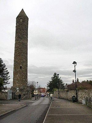
Clondalkin Round Tower
Irish round tower in South Dublin, Ireland
Distance: Approx. 3038 meters
Latitude and longitude: 53.322065,-6.395374
Clondalkin Round Tower (Irish: Cloigtheach Chluain Dolcáin) is an Irish round tower or cloigtheach founded by Saint Mochua, also known as Saint Cronan, and located in Clondalkin, South Dublin, Ireland. It is now a National Monument in Ireland. It's also become a museum that houses a café.
Greenogue
Distance: Approx. 2984 meters
Latitude and longitude: 53.303121,-6.477413
Greenogue () is a football ground located in Newcastle, South Dublin, Ireland.
Weather in this IP's area
light intensity drizzle
12 Celsius
12 Celsius
11 Celsius
13 Celsius
1029 hPa
96 %
1029 hPa
1020 hPa
800 meters
0.51 m/s
75 %
07:51:25
16:29:40