Country:
Region:
City:
Latitude and Longitude:
Time Zone:
Postal Code:
IP information under different IP Channel
ip-api
Country
Region
City
ASN
Time Zone
ISP
Blacklist
Proxy
Latitude
Longitude
Postal
Route
Luminati
Country
Region
bc
City
vancouver
ASN
Time Zone
America/Vancouver
ISP
CISCO-UMBRELLA
Latitude
Longitude
Postal
IPinfo
Country
Region
City
ASN
Time Zone
ISP
Blacklist
Proxy
Latitude
Longitude
Postal
Route
db-ip
Country
Region
City
ASN
Time Zone
ISP
Blacklist
Proxy
Latitude
Longitude
Postal
Route
ipdata
Country
Region
City
ASN
Time Zone
ISP
Blacklist
Proxy
Latitude
Longitude
Postal
Route
Popular places and events near this IP address
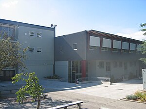
Eric Hamber Secondary School
Secondary school in Vancouver, British Columbia, Canada
Distance: Approx. 854 meters
Latitude and longitude: 49.24,-123.125
Eric Hamber Secondary School is a public secondary school located in the South Cambie neighbourhood of Vancouver, British Columbia, Canada. Eric Hamber is a comprehensive secondary school with approximately 1400 students. Each year, approximately 70% of the senior class graduate with honours standing.
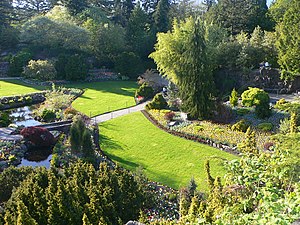
Queen Elizabeth Park, British Columbia
City park in Vancouver, British Columbia, Canada
Distance: Approx. 855 meters
Latitude and longitude: 49.24222222,-123.115
Queen Elizabeth Park is a 130-acre municipal park located in Vancouver, British Columbia, Canada. It is located on top of Little Mountain approximately 125 metres (410 ft) above sea level and is the location of former basalt quarries dug in the beginning of the twentieth century to provide materials for roads in the city.

Bloedel Floral Conservatory
Conservatory and aviary
Distance: Approx. 928 meters
Latitude and longitude: 49.2421,-123.1138
The Bloedel Floral Conservatory is a conservatory and aviary located at the top of Queen Elizabeth Park in Vancouver, British Columbia.

King Edward station
Metro Vancouver SkyTrain station
Distance: Approx. 577 meters
Latitude and longitude: 49.24916667,-123.11583333
King Edward is an underground station on the Canada Line of Metro Vancouver's SkyTrain rapid transit system. The station is located at the intersection of Cambie Street and King Edward Avenue in Vancouver, British Columbia, Canada, and serves the neighbourhoods of Riley Park–Little Mountain and South Cambie. The station is within walking distance of BC Children's Hospital, Nat Bailey Stadium, and Queen Elizabeth Park.

Shaughnessy, Vancouver
Neighbourhood in Vancouver, British Columbia, Canada
Distance: Approx. 755 meters
Latitude and longitude: 49.245,-123.133
Shaughnessy is an almost-entirely residential neighbourhood in Vancouver, British Columbia, Canada, spanning about 447 hectares in a relatively central locale. It is bordered by 16th Avenue to the north, 41st Avenue to the south, Oak Street to the east, and East Boulevard to the west. The older section of the neighbourhood, called "First Shaughnessy," is considered more prestigious and is bordered by 16th Avenue to the north, King Edward Avenue to the south, Oak Street to the east, and East Boulevard to the west.
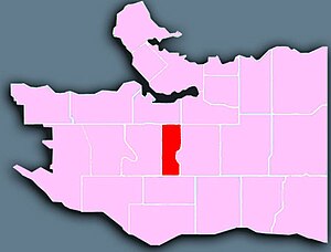
South Cambie
Distance: Approx. 205 meters
Latitude and longitude: 49.246,-123.122
South Cambie is a neighbourhood in the city of Vancouver, British Columbia, Canada, that is generally considered one of the smallest neighbourhoods in the city, both in size and in population. It is wedged between one of the city's largest parks and the upscale neighbourhood of Shaughnessy, and is known for a large cluster of medical facilities.
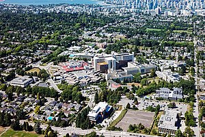
B.C. Women's Hospital & Health Centre
Hospital in British Columbia, Canada
Distance: Approx. 454 meters
Latitude and longitude: 49.243611,-123.124722
B.C. Women's Hospital & Health Centre, an agency of the Provincial Health Services Authority (PHSA), is a Canadian hospital located in Vancouver, British Columbia, Canada, specializing in women's health programs. It is the only facility in Western Canada dedicated to the health of women, newborns and families, and is the largest maternity hospital in the country. It is a teaching hospital and major provincial health care resource, and is a key component in women's health research.
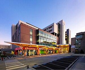
British Columbia Children's Hospital
Hospital in British Columbia, Canada
Distance: Approx. 385 meters
Latitude and longitude: 49.244444,-123.125556
British Columbia Children's Hospital is a medical facility located in Vancouver, British Columbia, and is an agency of the Provincial Health Services Authority. It specializes in health care for patients from birth to 16 years of age (possibly longer if followed by a specialist team). It is also a teaching and research facility for children's medicine.

Congregation Schara Tzedeck
Distance: Approx. 846 meters
Latitude and longitude: 49.2548097,-123.1270814
Congregation Schara Tzedeck is a Modern Orthodox synagogue located in Vancouver, British Columbia, Canada. The synagogue is the oldest synagogue and the largest Orthodox synagogue in Greater Vancouver. From Hebrew, the transliteration of the synagogue's name is the "Gates of Righteousness".
G. F. Strong Centre
Hospital in British Columbia, Canada
Distance: Approx. 182 meters
Latitude and longitude: 49.24722222,-123.12583333
GF Strong Rehabilitation Centre is the largest rehabilitation hospital in British Columbia. It is located in the South Cambie neighbourhood of Vancouver. It provides inpatient, outpatient, outreach and clinical support services to clients/patients across British Columbia and the Yukon in four programs: acquired brain injury, spinal cord injury, and neuromusculoskeletal.
Congregation Beth Israel (Vancouver)
Conservative Synagogue in Vancouver, British Columbia, Canada
Distance: Approx. 320 meters
Latitude and longitude: 49.246756,-123.127609
Congregation Beth Israel is an egalitarian Conservative synagogue located at 989 West 28th Avenue in Vancouver, British Columbia. It was founded in 1925, but did not formally incorporate until 1932. Its first rabbi was Ben Zion Bokser, hired that year.
BC Children's Hospital Foundation
Hospital in British Columbia, Canada
Distance: Approx. 385 meters
Latitude and longitude: 49.244444,-123.125556
BC Children's Hospital Foundation (BCCHF) is a Canadian non-profit registered charity that raises money to support the British Columbia Children's Hospital. The Foundation works with communities to raise funds for essentials including: life-saving equipment, research into childhood diseases, a wide range of medical staff and community child health education programs. Since 1982, BC Children's Hospital Foundation has partnered with children, families, health professionals, and other British Columbia residents to raise funds to support BC Children's Hospital, Sunny Hill Health Centre for Children, and the BC Children's Hospital Research Institute.
Weather in this IP's area
few clouds
8 Celsius
8 Celsius
7 Celsius
9 Celsius
1014 hPa
85 %
1014 hPa
1005 hPa
10000 meters
0.89 m/s
270 degree
16 %
07:22:19
16:31:58