Country:
 Netherlands
Region:
City:
Latitude and Longitude:
Time Zone:
Postal Code:
IP information under different IP Channel
ip-api
Country
Region
City
ASN
Time Zone
ISP
Blacklist
Proxy
Latitude
Longitude
Postal
Route
IPinfo
Country
Region
City
ASN
Time Zone
ISP
Blacklist
Proxy
Latitude
Longitude
Postal
Route
MaxMind
Country
Region
City
ASN
Time Zone
ISP
Blacklist
Proxy
Latitude
Longitude
Postal
Route
Luminati
Country
NLASN
Time Zone
Europe/Amsterdam
ISP
KPN B.V.
Latitude
Longitude
Postal
db-ip
Country
Region
City
ASN
Time Zone
ISP
Blacklist
Proxy
Latitude
Longitude
Postal
Route
ipdata
Country
Region
City
ASN
Time Zone
ISP
Blacklist
Proxy
Latitude
Longitude
Postal
Route
Popular places and events near this IP address
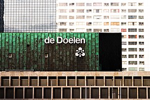
De Doelen
Concert venue and convention centre in the Netherlands
Distance: Approx. 442 meters
Latitude and longitude: 51.92166667,4.47305556
De Doelen is a concert venue and convention centre in Rotterdam, Netherlands. It was originally built in 1934 but then destroyed in 1940 during the German bombardment of Rotterdam in May 1940 at the outset of World War II. It was rebuilt in 1966, originally with one hall to which two more were added in the 1990s. It has a variety of facilities, including the Grote Zaal (Grand Hall), a 2,200-seat concert hall, two smaller halls which each seat about 700 people, and convention rooms.

Rotterdam Delftsche Poort railway station
Railway station in Rotterdam, the Netherlands
Distance: Approx. 300 meters
Latitude and longitude: 51.9253,4.47361
Rotterdam Delftsche Poort was a railway station of the Hollandsche IJzeren Spoorweg-Maatschappij in Rotterdam, Netherlands located on the Oude Lijn from Amsterdam Willemspoort station to Rotterdam. The station was located east of the present-day Rotterdam Centraal.

Stadhuis metro station
Metro station in Rotterdam, the Netherlands
Distance: Approx. 126 meters
Latitude and longitude: 51.92333333,4.47833333
Stadhuis (Dutch for town hall) is an underground subway station in the city of Rotterdam, and is located on Rotterdam Metro lines D and E. The station opened on 9 February 1968, the same date that the North-South Line (also temporarily called Erasmus line), of which it is a part, was opened. The station is located in the center of Rotterdam, underneath the Coolsingel, a major street through the center.

Delftse Poort
Twin-tower skyscraper next to Rotterdam Centraal railway station in Rotterdam, Netherlands
Distance: Approx. 400 meters
Latitude and longitude: 51.92397,4.47195
Delftse Poort (English: Delft Gate Building) is a twin-tower skyscraper complex at Weena 505 next to the Rotterdam Centraal railway station in Rotterdam, Netherlands. Tower I is 151.35 m (496.6 ft) with 41 stories, and Tower II is 93 m (305 ft) with 25 stories. Until May 2009, Tower I was the tallest office tower in the Netherlands.

Rotterdam Hofplein railway station
Former railway station in Rotterdam, the Netherlands
Distance: Approx. 300 meters
Latitude and longitude: 51.92694444,4.47916667
Rotterdam Hofplein railway station in the Netherlands is a former main-line and RandstadRail station. It was the terminus of the former Hofpleinlijn (Hofplein line) which ran trains between Rotterdam and Scheveningen, and were later curtailed to The Hague central station. It was located very close to the railway line between Rotterdam Centraal and Rotterdam Blaak, but never had a direct connection to it.

Westerkerk (Rotterdam)
Distance: Approx. 291 meters
Latitude and longitude: 51.9223,4.4752
The Westerkerk (Dutch pronunciation: [ʋɛstərkɛr(ə)k]; English: Western Church) was a Protestant church on the Kruiskade in Rotterdam, Netherlands completed in 1870 and destroyed in the bombing of Rotterdam in May 1940.

Trams in Rotterdam
Distance: Approx. 383 meters
Latitude and longitude: 51.92166667,4.48111111
The Rotterdam tramway network (Dutch: Rotterdams tramnet) is a key element of the overall public transport arrangements in Rotterdam, Netherlands. Opened in 1879, the network currently has nine regular tramlines, and three special or seasonal tramlines. It has been operated since 1927 by Rotterdamse Elektrische Tram (RET).

Coolsingel
Street in central Rotterdam, Netherlands
Distance: Approx. 197 meters
Latitude and longitude: 51.92272222,4.47863889
Coolsingel is a street in central Rotterdam. It is located in the Cool district. The street leads from the Hofplein to the Churchillplein.
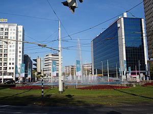
Hofplein
Town square in Rotterdam, the Netherlands
Distance: Approx. 12 meters
Latitude and longitude: 51.92430556,4.47780556
Hofplein is a major public town square in Rotterdam, the Netherlands. The square lies on a crossing of the Weena, the Schiekade and the Coolsingel. In the center of the square a large fountain is situated.

Rotterdam City Hall
Seat of local government in Rotterdam
Distance: Approx. 227 meters
Latitude and longitude: 51.92277778,4.47972222
Rotterdam City Hall was built between 1914 and 1920 by Henri Evers. It is one of the few buildings in the center of Rotterdam that survived the bombing of May 14, 1940. Since 10 October 2000 it has been recognized as a Rijksmonument.
FG Food Labs
Restaurant in Rotterdam, the Netherlands
Distance: Approx. 238 meters
Latitude and longitude: 51.926253,4.479472
FG Food Labs is a restaurant in Rotterdam by chef François Geurds. Since 2015, the restaurant has one Michelin star. GaultMillau awarded the restaurant 16.5 points out of a maximum of 20 points.
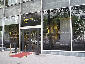
Joelia
Restaurant in Rotterdam, the Netherlands
Distance: Approx. 77 meters
Latitude and longitude: 51.923706,4.477678
Joelia is a restaurant in Rotterdam, Netherlands. The restaurant received a Michelin star in 2016. The Dutch royal couple Willem-Alexander of the Netherlands and Queen Máxima of the Netherlands celebrated their fifteenth wedding anniversary in Joelia.
Weather in this IP's area
few clouds
19 Celsius
19 Celsius
18 Celsius
21 Celsius
1009 hPa
75 %
1009 hPa
1008 hPa
10000 meters
5.66 m/s
190 degree
20 %
07:05:59
20:13:44