Country:
 Netherlands
Region:
City:
Latitude and Longitude:
Time Zone:
Postal Code:
IP information under different IP Channel
ip-api
Country
Region
City
ASN
Time Zone
ISP
Blacklist
Proxy
Latitude
Longitude
Postal
Route
IPinfo
Country
Region
City
ASN
Time Zone
ISP
Blacklist
Proxy
Latitude
Longitude
Postal
Route
MaxMind
Country
Region
City
ASN
Time Zone
ISP
Blacklist
Proxy
Latitude
Longitude
Postal
Route
Luminati
Country
NLASN
Time Zone
Europe/Amsterdam
ISP
SURF B.V.
Latitude
Longitude
Postal
db-ip
Country
Region
City
ASN
Time Zone
ISP
Blacklist
Proxy
Latitude
Longitude
Postal
Route
ipdata
Country
Region
City
ASN
Time Zone
ISP
Blacklist
Proxy
Latitude
Longitude
Postal
Route
Popular places and events near this IP address

University of Twente
University in The Netherlands
Distance: Approx. 3333 meters
Latitude and longitude: 52.2425,6.8525
The University of Twente (Dutch: Universiteit Twente; Dutch pronunciation: [ynivɛrsiˈtɛit ˈtʋɛntə], abbr. UT) is a public technical university located in Enschede, Netherlands. The university has been placed in the top 170 universities in the world by multiple central ranking tables.

Hengelo
Municipality in Overijssel, Netherlands
Distance: Approx. 1558 meters
Latitude and longitude: 52.26527778,6.79305556
Hengelo (Dutch: [ˈɦɛŋəloː] ; Tweants: Hengel) is a city in the eastern part of the Netherlands, in the Twente region, in the province of Overijssel. It is part of a larger urban area that also includes Enschede, Borne, Almelo and Oldenzaal. Due to its geomorphology, being situated relatively low in the landscape, Hengelo is a place where streams converge.
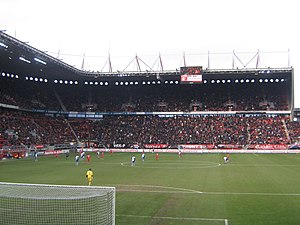
De Grolsch Veste
Dutch football stadium
Distance: Approx. 3192 meters
Latitude and longitude: 52.23666667,6.8375
De Grolsch Veste (Dutch pronunciation: [də ˈɣrɔls ˌfɛstə], English: The Grolsch Fortress, previously known as Arke Stadion [ˈɑrkə ˌstaːdijɔn]) is the stadium of football club FC Twente. It is located in Enschede, Netherlands, at the Business & Science Park, near the University of Twente. The stadium has an all-seated capacity of 30,205 with a standard pitch heating system and has a promenade instead of fences around the stands.

ITC Enschede
Distance: Approx. 3711 meters
Latitude and longitude: 52.23831389,6.85373611
The International Institute for Geo-Information Science and Earth Observation (ITC) was an institute of higher (tertiary) education located in Enschede, Netherlands. As of 1 January 2010 it has been incorporated into the University of Twente as the sixth faculty, while preserving its unique international character as a faculty sui generis, and is now formally known as University of Twente, Faculty of Geo-Information Science and Earth Observation (ITC).

Hengelo railway station
Railway station in the Netherlands
Distance: Approx. 1436 meters
Latitude and longitude: 52.26194444,6.79416667
Hengelo is a railway station in Hengelo, Netherlands. The station was opened on 18 October 1865 and is on the Almelo–Salzbergen railway and the Zutphen–Glanerbeek railway. It underwent a major renovation in 2010.

Enschede Kennispark railway station
Railway station in the Netherlands
Distance: Approx. 3148 meters
Latitude and longitude: 52.2375,6.83861111
Enschede Kennispark is a railway station in Enschede, the Netherlands. The station was opened on 22 November 1996 and is located on the Zutphen–Glanerbeek railway. The train services are operated by Nederlandse Spoorwegen.

Hengelo Oost railway station
Railway station in Hengelo, Netherlands
Distance: Approx. 829 meters
Latitude and longitude: 52.26888889,6.81944444
Hengelo Oost is a railway station in Hengelo, The Netherlands. The station was opened on 1 June 1975 and is on the Almelo–Salzbergen railway.
Hengelo Gezondheidspark railway station
Railway station in the Netherlands
Distance: Approx. 2837 meters
Latitude and longitude: 52.26166667,6.77361111
Hengelo Gezondheidspark (Dutch pronunciation: [ˈɦɛŋəloː ɣəˈzɔntɦɛitspɑr(ə)k]) is a railway station in Hengelo, The Netherlands.

Fanny Blankers-Koen Stadion
Distance: Approx. 1078 meters
Latitude and longitude: 52.25314444,6.808475
Fanny Blankers-Koen Stadion (Dutch pronunciation: [ˈfɑni ˈblɑŋkərs ˈkun ˌstaːdijɔn]) is a multi-use stadium in Hengelo, Netherlands. It is currently used mostly for athletics meets, especially the annual Fanny Blankers-Koen Games, and also was the venue for the European Athletics Junior Championships in July 2007. It holds more than 8,000 people and is named after the Dutch athlete, Fanny Blankers-Koen.

Bataafs Lyceum
Public high school in Hengelo, Netherlands
Distance: Approx. 1791 meters
Latitude and longitude: 52.274046,6.798016
The Bataafs Lyceum is a public high school in Hengelo, Netherlands. The Bataafs Lyceum is part of a public school division called the Openbare Scholengemeenschap Hengelo and offers HAVO and VWO level education. The building is located at the Sloetsweg, next to the Montessori College Twente and diagonally opposite to the Avila College Hengelo.

Torentje van Drienerlo
Public artwork by Wim T. Schippers
Distance: Approx. 3371 meters
Latitude and longitude: 52.24277778,6.85361111
The Torentje van Drienerlo (pronounced [tɔrɛntʲə vɑn drinɛrloː]; Dutch for "Drienerlo Steeple") is a 1979 artwork by Dutch artist Wim T. Schippers, located on the campus of the University of Twente in Enschede.

Twekkelo
Hamlet in Overijssel, Netherlands
Distance: Approx. 3181 meters
Latitude and longitude: 52.23333333,6.81666667
Twekkelo is a hamlet in Twente, in the province of Overijssel. It is located between Enschede and Hengelo. It had 240 registered inhabitants in 2008.
Weather in this IP's area
broken clouds
21 Celsius
21 Celsius
20 Celsius
22 Celsius
1010 hPa
77 %
1010 hPa
1007 hPa
10000 meters
3.13 m/s
5.36 m/s
171 degree
78 %
06:56:13
20:04:48