Country:
 Germany
Region:
City:
Latitude and Longitude:
Time Zone:
Postal Code:
IP information under different IP Channel
ip-api
Country
Region
City
ASN
Time Zone
ISP
Blacklist
Proxy
Latitude
Longitude
Postal
Route
IPinfo
Country
Region
City
ASN
Time Zone
ISP
Blacklist
Proxy
Latitude
Longitude
Postal
Route
MaxMind
Country
Region
City
ASN
Time Zone
ISP
Blacklist
Proxy
Latitude
Longitude
Postal
Route
Luminati
Country
DERegion
by
City
munich
ASN
Time Zone
Europe/Berlin
ISP
European Patent Organisation
Latitude
Longitude
Postal
db-ip
Country
Region
City
ASN
Time Zone
ISP
Blacklist
Proxy
Latitude
Longitude
Postal
Route
ipdata
Country
Region
City
ASN
Time Zone
ISP
Blacklist
Proxy
Latitude
Longitude
Postal
Route
Popular places and events near this IP address

Obergiesing
Borough of Munich, Germany
Distance: Approx. 1154 meters
Latitude and longitude: 48.11111111,11.59444444
Obergiesing (Central Bavarian: Obagiasing) is a borough of Munich, about 5km south-east of the city center. The larger part is residential or a mix of business and residential, but there are also a number of recreational facilities.

Bundesautobahn 8
Federal motorway in Germany
Distance: Approx. 1516 meters
Latitude and longitude: 48.09459,11.61461
Bundesautobahn 8 (translates from German as Federal Motorway 8, short form Autobahn 8, abbreviated as BAB 8 or A 8) is an autobahn in southern Germany that runs 497 km (309 mi) from the Luxembourg A13 motorway at Schengen via Neunkirchen, Pirmasens, Karlsruhe, Pforzheim, Stuttgart, Ulm, Augsburg and Munich to the Austrian West Autobahn near Salzburg. The A8 is a significant east–west transit route. Its construction began in March 1934 during Nazi rule as a Reichsautobahn, the section between Karlsruhe and Salzburg having been completed by the time road works were discontinued in World War II. Although most parts have been modernized and extended since, significant sections remain in their original configuration from the 1930s - 2+2 lanes, no emergency lanes, steep hills and tight curves.

Munich-Giesing station
Station of the Munich S-Bahn and U-Bahn
Distance: Approx. 987 meters
Latitude and longitude: 48.11027778,11.59638889
Munich-Giesing station (‹See Tfd›German: Bahnhof München-Giesing) is a railway station in the district of Obergiesing in the Bavarian state capital of Munich and is a station of the Munich S-Bahn and the Munich U-Bahn. It is located on the Munich East–Deisenhofen railway, the Munich-Giesing–Kreuzstraße railway, which branches off to the east from the Munich East–Deisenhofen line next to the Perlacher Forst cemetery, and the second trunk line of the Munich U-Bahn. The station is served by about 280 S-Bahn services each day.

Karl-Preis-Platz station
Station of the Munich U-Bahn
Distance: Approx. 1153 meters
Latitude and longitude: 48.11805556,11.60861111
Karl-Preis-Platz is a Munich U-Bahn station on line U2. Since 12. December 2011 it is also used by the booster line U7 in the morning.

Innsbrucker Ring station
Station of the Munich U-Bahn
Distance: Approx. 1597 meters
Latitude and longitude: 48.12027778,11.61944444
Innsbrucker Ring is a U2 - U5 interchange station of the Munich U-Bahn. It is located under the Innsbrucker Ring and connects lines U2 and U5, allowing cross-platform interchange. The distance of the U 2 line to Karl-Preis-Platz measures 868 m.
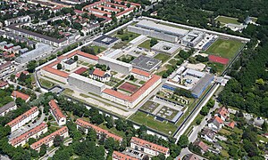
Stadelheim Prison
Prison in Munich, Germany
Distance: Approx. 1554 meters
Latitude and longitude: 48.09972222,11.59194444
Stadelheim Prison (‹See Tfd›German: Justizvollzugsanstalt München), in Munich's Giesing district, is one of the largest prisons in Germany. Founded in 1894, it was the site of many executions, particularly by guillotine during the Nazi period.

University of Television and Film Munich
German film school based in Munich
Distance: Approx. 818 meters
Latitude and longitude: 48.10916,11.59831
The University of Television and Film Munich (German: Hochschule für Fernsehen und Film München, short: HFF Munich) is a publicly funded film school in Munich, Germany. The school was established in 1966 by decree of the Bavarian government. The University of Television and Film Munich is one of Germany's most reputable film schools with about 350 students enrolled.

St. Mary's Church, Munich
Distance: Approx. 840 meters
Latitude and longitude: 48.114075,11.615142
Saint Mary Ramersdorf (Sankt Maria Ramersdorf) in the district Ramersdorf-Perlach of Munich is a parish church and church of pilgrimage.

Munich St.-Martin-Straße station
Railway station in Germany
Distance: Approx. 1565 meters
Latitude and longitude: 48.1186,11.5958
Munich St.-Martin-Straße station is a railway station in Munich, Germany, spanning the street bearing the same name. It is on the Munich East–Deisenhofen railway and is served by lines S 3 and S 7 of the Munich S-Bahn. It is in close proximity to the southwest Europe headquarters of Nokia Siemens Networks in Munich.

MVG Museum
Museum
Distance: Approx. 801 meters
Latitude and longitude: 48.10227778,11.60201389
The MVG Museum of the Münchner Verkehrsgesellschaft is a public transportation museum for the presentation of historical and modern public transportation in Munich. In an area of over 5,000 square meters (54,000 sq ft) are around 25 historical trams, buses and work vehicles on exhibit. The streetcars are arranged on two tracks leading through the entire hall.

Agfa-Commando
Distance: Approx. 1174 meters
Latitude and longitude: 48.106861,11.593361
Agfa-Commando is the widely used name for the München-Giesing - Agfa Kamerawerke satellite camp of the Dachau concentration camp. By October 1944, the camp housed about five hundred women. They were used as slave laborers in the Agfa camera factory (part of the IG Farben group) in München-Giesing, a suburb on the S.W. side of Munich 14 miles (23 km) from the main camp of Dachau.

Ramersdorf-Perlach
Borough of Munich, Germany
Distance: Approx. 1302 meters
Latitude and longitude: 48.1028,11.625
Ramersdorf-Perlach is a borough of Munich. It is located south-east of the city center and is the most populous of Munich's boroughs with a population of about 116,000. It consists of the five districts Ramersdorf, Balanstraße West, Altperlach, Neuperlach and Waldperlach.
Weather in this IP's area
overcast clouds
16 Celsius
16 Celsius
15 Celsius
17 Celsius
1014 hPa
78 %
1014 hPa
951 hPa
10000 meters
0.89 m/s
1.34 m/s
274 degree
100 %
07:12:59
18:53:07