Country:
 Netherlands
Region:
City:
Latitude and Longitude:
Time Zone:
Postal Code:
IP information under different IP Channel
ip-api
Country
Region
City
ASN
Time Zone
ISP
Blacklist
Proxy
Latitude
Longitude
Postal
Route
IPinfo
Country
Region
City
ASN
Time Zone
ISP
Blacklist
Proxy
Latitude
Longitude
Postal
Route
MaxMind
Country
Region
City
ASN
Time Zone
ISP
Blacklist
Proxy
Latitude
Longitude
Postal
Route
Luminati
Country
NLRegion
nh
City
amsterdam
ASN
Time Zone
Europe/Amsterdam
ISP
LeaseWeb Netherlands B.V.
Latitude
Longitude
Postal
db-ip
Country
Region
City
ASN
Time Zone
ISP
Blacklist
Proxy
Latitude
Longitude
Postal
Route
ipdata
Country
Region
City
ASN
Time Zone
ISP
Blacklist
Proxy
Latitude
Longitude
Postal
Route
Popular places and events near this IP address

Beit Ha'Chidush
Synagogue in Amsterdam, Netherlands
Distance: Approx. 119 meters
Latitude and longitude: 52.37027778,4.90527778
Beit Ha'Chidush (meaning House of Renewal in Hebrew), abbreviated as BHC is a Progressive Jewish congregation, located in Amsterdam, in the North Holland region of The Netherlands. The congregation was founded in 1995 by predominately expatriate Jews with secular and religious backgrounds who wanted to create a welcoming, inspiring and renewed Jewish congregation. Since 1997, the congregation has worshiped from the Uilenburg Synagogue, a synagogue located at Nieuwe Uilenburgerstraat 91, in Central Amsterdam.
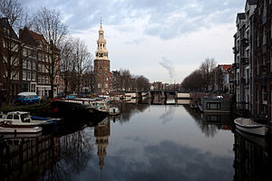
Montelbaanstoren
Distance: Approx. 129 meters
Latitude and longitude: 52.37205833,4.90568333
The Montelbaanstoren is a tower on bank of the Oudeschans – a canal in Amsterdam. The original tower was built in 1516 as part of the Walls of Amsterdam for the purpose of defending the city and the harbour. The top half, designed by Hendrick de Keyser, was extended to its current, decorative form in 1606.

Lastage
Neighbourhood of Amsterdam in North Holland, Netherlands
Distance: Approx. 225 meters
Latitude and longitude: 52.373084,4.903207
Lastage is a neighborhood in the Centrum borough of Amsterdam, Netherlands. It is located between the Geldersekade and Oudeschans canals, just east of old medieval city. Today, the neighbourhood is also known as Nieuwmarktbuurt due to the fact that the Nieuwmarkt is comprised in the area; it is protected as a heritage site.
Uilenburg
Neighborhood of Amsterdam in North Holland, Netherlands
Distance: Approx. 110 meters
Latitude and longitude: 52.37027778,4.905
Uilenburg is a neighborhood of Amsterdam, Netherlands. Uilenburg is an island surrounded by the Oudeschans canal to the northwest, the Houtkopersburgwal canal to the southwest, the Uilenburgergracht to the southeast and the Rapenburgwal to the northeast. The Nieuwe Uilenburgerstraat runs along the length of the island, crossing the Houtkopersburgwal and Uilenburgergracht by bridges.

Maupoleum
Distance: Approx. 240 meters
Latitude and longitude: 52.36926111,4.90286667
The Maupoleum (1971–1994) was a building on Amsterdam's Jodenbreestraat. Built in 1971, it acquired a reputation for being unattractive before being demolished in 1994.

Rechtboomssloot
Canal in Amsterdam
Distance: Approx. 202 meters
Latitude and longitude: 52.372651,4.902607
The Rechtboomssloot, or Recht Boomssloot, is a canal in the Lastage (Nieuwmarktbuurt) neighborhood in the center of Amsterdam.

Kromboomssloot
Canal in Amsterdam
Distance: Approx. 150 meters
Latitude and longitude: 52.371389,4.902222
The Kromboomssloot, or Krom Boomssloot, is a canal in the Lastage (Nieuwmarktbuurt) neighborhood in the center of Amsterdam. It provides a transverse navigation from the Rechtboomssloot and was previously called Dwarsboomssloot. As the names indicate, the Rechtboomssloot (Straight Boom Ditch) is completely straight, while there is a curve in the Kromboomssloot (Crooked Boom Ditch).

Oudeschans, Amsterdam
Canal in Amsterdam
Distance: Approx. 30 meters
Latitude and longitude: 52.371389,4.904722
The Oudeschans, or Oude Schans (Old Rampart), originally the Nieuwe Gracht, is a wide canal in the eastern part of the inner city of Amsterdam.

Houtkopersburgwal
Canal in Amsterdam
Distance: Approx. 202 meters
Latitude and longitude: 52.369685,4.902754
The Houtkopersburgwal is a short secondary canal in Amsterdam. It is located in the east of the Amsterdam-Centrum district in the Lastage neighborhood.

Uilenburgergracht
Canal in Amsterdam
Distance: Approx. 159 meters
Latitude and longitude: 52.370097,4.905893
The Uilenburgergracht is a secondary canal in Amsterdam, the Netherlands. It is located east of the Amsterdam-Centrum district, in the Lastage neighborhood. The Uilenburgergracht defines the southeastern border of Uilenburg Island.
Rapenburgwal
Canal in Amsterdam
Distance: Approx. 199 meters
Latitude and longitude: 52.37152,4.907275
The Rapenburgwal (Dutch pronunciation: [ˈraːpə(m)ˌbʏr(ə)xʋɑl]) is a secondary canal in Amsterdam in the east of the Amsterdam-Centrum district, in the Lastage neighborhood.

Snoekjesgracht
Canal in Amsterdam
Distance: Approx. 223 meters
Latitude and longitude: 52.370438,4.901358
The Snoekjesgracht (Pike Canal) is a small canal in Amsterdam, in the Lastage neighborhood.
Weather in this IP's area
scattered clouds
14 Celsius
14 Celsius
13 Celsius
15 Celsius
1018 hPa
86 %
1018 hPa
1017 hPa
10000 meters
6.17 m/s
210 degree
40 %
08:16:38
18:32:58