Country:
 Kazakhstan
Region:
City:
Latitude and Longitude:
Time Zone:
Postal Code:
IP information under different IP Channel
ip-api
Country
Region
City
ASN
Time Zone
ISP
Blacklist
Proxy
Latitude
Longitude
Postal
Route
IPinfo
Country
Region
City
ASN
Time Zone
ISP
Blacklist
Proxy
Latitude
Longitude
Postal
Route
MaxMind
Country
Region
City
ASN
Time Zone
ISP
Blacklist
Proxy
Latitude
Longitude
Postal
Route
Luminati
Country
KZRegion
23
City
atyrau
ASN
Time Zone
Asia/Atyrau
ISP
Kar-Tel LLC
Latitude
Longitude
Postal
db-ip
Country
Region
City
ASN
Time Zone
ISP
Blacklist
Proxy
Latitude
Longitude
Postal
Route
ipdata
Country
Region
City
ASN
Time Zone
ISP
Blacklist
Proxy
Latitude
Longitude
Postal
Route
Popular places and events near this IP address
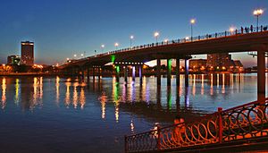
Atyrau
City in Atyrau Region, western Kazakhstan
Distance: Approx. 151 meters
Latitude and longitude: 47.11666667,51.88333333
Atyrau (UK: , US: ; Kazakh: Атырау, pronounced [ɑtəˈrɑw] ; Russian: Атырау), known until 1991 as Guryev (Russian: Гурьев), is a city in Kazakhstan and the capital of Atyrau Region. Atyrau is a transcontinental city, at the mouth of the Ural River on the Caspian Sea, between Europe and Asia, 2,700 kilometres (1,700 miles) west of Almaty and 351 kilometres (218 miles) east of the Russian city of Astrakhan. Atyrau is famous for its oil and gas industries.
Atyrau Region
Region of Kazakhstan
Distance: Approx. 151 meters
Latitude and longitude: 47.11666667,51.88333333
Atyrau Region (Kazakh: Атырау облысы, romanized: Atyrau oblysy; Russian: Атырауская область) formerly known as Guryev Region (Russian: Гурьевская область) until 1991, is one of the regions of Kazakhstan, in the west of the country around the northeast of the Caspian Sea. Its capital is the city of Atyrau, with a population of 355,117; the region itself has a population of 681,241, of which Kazakhs make up more than 90%.
Munaishy Stadium
Distance: Approx. 3081 meters
Latitude and longitude: 47.094085,51.908324
Munayshy Stadium is a multi-use stadium in Atyrau, Kazakhstan. It is currently used mostly for football matches and is the home stadium of FC Atyrau.

Atyrau Airport
Airport in Kazakhstan
Distance: Approx. 4874 meters
Latitude and longitude: 47.12194444,51.82138889
ATMA Atyrau Airport (Kazakh: Atyrau Halyqaralyq Äuejaiy) (IATA: GUW, ICAO: UATG) is an airport located 8 km (5.0 mi) northwest of Atyrau, Kazakhstan. It is the lowest international commercial airport in the world at 22 m (72 ft) below sea level.
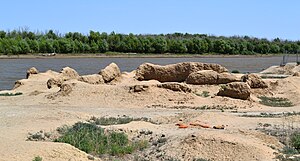
Neocomian Sands (Kazakhstan)
Geologic formation in Kazakhstan
Distance: Approx. 2186 meters
Latitude and longitude: 47.1,51.9
The Neocomian Sands is an Early Cretaceous geologic formation in Atyrau, Kazakhstan. Dinosaur remains have been recovered from the formation.

Apostolic Administration of Atyrau
Catholic pastoral area in Kazakhstan
Distance: Approx. 1439 meters
Latitude and longitude: 47.1137,51.9037
The Apostolic Administration of Atyrau is a pastoral area sui iuris, not yet fully a diocese, in western Kazakhstan which forms part of the Roman Catholic Church in this country, namely of the metropolitan Roman Catholic Archdiocese of Mary Most Holy in Nur-Sultan. Its head is a prelate called Apostolic Administrator, member of the Catholic Bishops’ Conference of Central Asia. His see is the Cathedral of the Transfiguration of Our Lord, in Atyrau.
Balyqshy
Place in Atyrau, Kazakhstan
Distance: Approx. 5768 meters
Latitude and longitude: 47.06666667,51.86666667
Balyqshy (Kazakh: Балықшы, Balyqşy, بالىقشى) is a town in Atyrau Region, southwest Kazakhstan. It lies at an altitude of 17 m (56 ft) below sea level, a few kilometres from Atyrau.
Manjali Mosque
Mosque in Atyrau, Kazakhstan
Distance: Approx. 1690 meters
Latitude and longitude: 47.1058359,51.9005701
The Manjali Mosque (Kazakh: Иманғали мешіті, Imanǵalı meshiti; Russian: Мечеть Имангали, romanized: Mechet' Imangali) is located on Satpayev Avenue in the center of Atyrau, Kazakhstan. Construction began in 1999 and was completed in 2001. The mosque opened for public use on 5 May 2001 and can accommodate 600 worshipers.
Weather in this IP's area
clear sky
9 Celsius
7 Celsius
9 Celsius
9 Celsius
1020 hPa
46 %
1020 hPa
1023 hPa
10000 meters
3 m/s
40 degree
07:16:46
19:35:00