Country:
 Austria
Region:
City:
Latitude and Longitude:
Time Zone:
Postal Code:
IP information under different IP Channel
ip-api
Country
Region
City
ASN
Time Zone
ISP
Blacklist
Proxy
Latitude
Longitude
Postal
Route
IPinfo
Country
Region
City
ASN
Time Zone
ISP
Blacklist
Proxy
Latitude
Longitude
Postal
Route
MaxMind
Country
Region
City
ASN
Time Zone
ISP
Blacklist
Proxy
Latitude
Longitude
Postal
Route
Luminati
Country
ATASN
Time Zone
Europe/Vienna
ISP
Steiermaerkische Krankenanstaltengesellschaft mbH
Latitude
Longitude
Postal
db-ip
Country
Region
City
ASN
Time Zone
ISP
Blacklist
Proxy
Latitude
Longitude
Postal
Route
ipdata
Country
Region
City
ASN
Time Zone
ISP
Blacklist
Proxy
Latitude
Longitude
Postal
Route
Popular places and events near this IP address

University of Natural Resources and Life Sciences, Vienna
University of life sciences in Vienna, Austria
Distance: Approx. 911 meters
Latitude and longitude: 48.23666667,16.33722222
The University of Natural Resources and Life Sciences, Vienna, or simply BOKU (derived from its German name, Universität für Bodenkultur Wien, German pronunciation: [ˌunivɛʁziˈtɛːt fyːɐ̯ ˈboːdn̩kʊlˌtuːɐ̯ viːn] ), founded in 1872, is an education and research centre for renewable resources in Vienna, Austria. BOKU combines expertise in the fields of natural sciences, engineering and biotechnology as well as social and economic sciences. In research and teaching, it focuses on the conservation and development of protection for habitats, economy and living standards the management of natural resources and environment the protection of food and health BOKU sees itself as an innovation leader in the green economy, with the goal of integrating sustainability into all processes in society.

Jewish cemetery, Währing
Distance: Approx. 461 meters
Latitude and longitude: 48.2325,16.35111111
The Jewish Cemetery in Währing, opened in 1784, was the main burial site for members of the Israelitische Kultusgemeinde Wien. Besides the St. Marx Cemetery it is the last remaining cemetery of Vienna in the Biedermeier style.

Lauder Business School
Distance: Approx. 689 meters
Latitude and longitude: 48.24222222,16.35305556
Lauder Business School is an English-language business school in Vienna, Austria, operating as a "University of Applied Sciences" in the Austrian education system. Lauder Business School (LBS) was founded in 2003 as a University of Applied Sciences with financial help from Ronald S. Lauder. There are currently app.
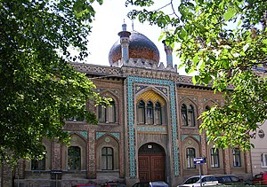
Zacherlfabrik
Distance: Approx. 834 meters
Latitude and longitude: 48.24388889,16.35138889
The Zacherl factory (Zacherlfabrik) is a former factory in the 19th district of Vienna, Döbling. It was built in an oriental style.

Döbling Parish Church
Distance: Approx. 670 meters
Latitude and longitude: 48.2425,16.35027778
The Döbling Parish Church (Döblinger Pfarrkirche) is a Roman Catholic parish church in the suburb of Oberdöbling in the 19th district of Vienna, Döbling.
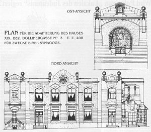
Döbling Synagogue
Former synagogue in Vienna, Austria
Distance: Approx. 434 meters
Latitude and longitude: 48.23944444,16.35333333
The Döbling Synagogue (German: Synagoge Döbling) was a former Jewish synagogue that was located in the Dollinergasse in the suburb of Oberdöbling, in Döbling, in the 19th district of Vienna, Austria. Completed in 1907, the building was ruined and partially destroyed in the Kristallnacht pogrom of November 1938. Later, the synagogue was deconsecrated and in 1995, it was replaced with a modern apartment tower.

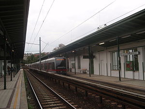
Spittelau station
Vienna U-Bahn station
Distance: Approx. 638 meters
Latitude and longitude: 48.2356,16.358
Spittelau is a station on U4 and U6 of the Vienna U-Bahn. It combines with Wien Spittelau railway station, which is operated by the Austrian Federal Railways (ÖBB), to form a multistorey interchange station. The U4 platforms at Spittelau, along with the ÖBB platforms served by regional trains and by line S40 of the Vienna S-Bahn, are at ground level.
Nußdorfer Straße station
Vienna U-Bahn station
Distance: Approx. 618 meters
Latitude and longitude: 48.2313,16.3524
Nußdorfer Straße is a station on U6 of the Vienna U-Bahn. It is located in the Alsergrund District. It opened in 1989.

Arthur-Schnitzler-Hof
Residential block in Vienna, Austria
Distance: Approx. 538 meters
Latitude and longitude: 48.232344,16.353214
The Arthur-Schnitzler-Hof is a residential tower block in Döbling (City District 19), a quarter on the northern side of central Vienna. It was built between 1959 and 1960, according to plans produced by the architects Michel Engelhart and Alois Machatschek. It comprises 47 residential apartments.

St. Canisius's Church, Vienna
Distance: Approx. 904 meters
Latitude and longitude: 48.2285,16.3516
The St. Canisius's Church is a Roman Catholic parish church in the 9th District of Vienna, Alsergrund.

Wien Oberdöbling railway station
Railway station in Vienna, Austria
Distance: Approx. 941 meters
Latitude and longitude: 48.24416667,16.34416667
Wien Oberdöbling is a railway station serving Döbling, the nineteenth district of Vienna.

Wien Krottenbachstraße railway station
Railway station in Vienna, Austria
Distance: Approx. 734 meters
Latitude and longitude: 48.24,16.34111111
Wien Krottenbachstraße is a railway station serving Döbling, the nineteenth district of Vienna.
Weather in this IP's area
overcast clouds
11 Celsius
10 Celsius
10 Celsius
12 Celsius
1024 hPa
76 %
1024 hPa
1001 hPa
10000 meters
1.79 m/s
4.92 m/s
167 degree
90 %
07:20:18
17:58:24