Country:
 USA
USARegion:
City:
Latitude and Longitude:
Time Zone:
Postal Code:
IP information under different IP Channel
ip-api
Country
Region
City
ASN
Time Zone
ISP
Blacklist
Proxy
Latitude
Longitude
Postal
Route
IPinfo
Country
Region
City
ASN
Time Zone
ISP
Blacklist
Proxy
Latitude
Longitude
Postal
Route
MaxMind
Country
Region
City
ASN
Time Zone
ISP
Blacklist
Proxy
Latitude
Longitude
Postal
Route
Luminati
Country
USRegion
tx
City
abilene
ASN
Time Zone
America/Chicago
ISP
NTS-ONLINE
Latitude
Longitude
Postal
db-ip
Country
Region
City
ASN
Time Zone
ISP
Blacklist
Proxy
Latitude
Longitude
Postal
Route
ipdata
Country
Region
City
ASN
Time Zone
ISP
Blacklist
Proxy
Latitude
Longitude
Postal
Route
Popular places and events near this IP address

Abilene, Texas
City in Texas, United States
Distance: Approx. 2038 meters
Latitude and longitude: 32.45,-99.75
Abilene ( AB-i-leen) is a city in Taylor and Jones Counties, Texas, United States. Its population was 125,182 at the 2020 census. It is the principal city of the Abilene metropolitan statistical area, which had a population of 176,579 as of 2020.
McMurry University
Methodist university in Abilene, Texas, US
Distance: Approx. 1440 meters
Latitude and longitude: 32.43,-99.75
McMurry University is a private Methodist university in Abilene, Texas, United States. It was founded in 1923 and named after William Fletcher McMurry. The university offers forty-five majors in the fields of fine arts, humanities, social and natural sciences, education, business, and religion, and nine pre-professional programs, including nursing, dentistry, medicine, pharmacy, veterinary, and law.
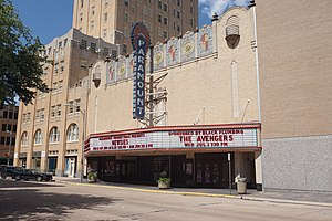
Paramount Theatre (Abilene, Texas)
Distance: Approx. 3344 meters
Latitude and longitude: 32.45222222,-99.73388889
The Paramount Theatre is located in downtown Abilene, Texas at 352 Cypress Street. The Paramount was built in 1930 by H. O. Wooten, adjacent to his Hotel Wooten. The theatre opened on May 19, 1930, and the first film shown was Safety in Numbers.
KVVO-LP
Radio station
Distance: Approx. 3207 meters
Latitude and longitude: 32.45,-99.734
KVVO-LP (94.1 FM; "Inspirational Country Radio") is a radio station located in Abilene, Texas, broadcasting a Christian country music format. Inspirational Country Radio is owned by licensee Wildfire Global Church.

The Grace Museum
Art museum in Abilene, Texas
Distance: Approx. 3155 meters
Latitude and longitude: 32.44972222,-99.73444444
The Grace Museum is located in Abilene, Texas, United States. The museum is accredited by the American Alliance of Museums (AAM). The Grace Museum houses five art galleries featuring rotating art exhibitions and artwork from the permanent collection; a history gallery with permanent and rotating exhibits featuring Abilene, Taylor County, and West Texas artifacts; an art library; an education center and an interactive gallery for children and families.
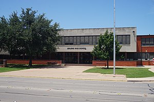
Abilene High School (Texas)
Public school in Abilene, Texas, United States
Distance: Approx. 2379 meters
Latitude and longitude: 32.45611111,-99.75583333
Abilene High School is a public high school located in Abilene, Texas. AHS is classified as a Division 5A school and is part of the Abilene Independent School District. Abilene High School is the name given to three different schools in the past 150 years.
National Center for Children's Illustrated Literature
American museum
Distance: Approx. 3055 meters
Latitude and longitude: 32.449836,-99.735759
The National Center for Children's Illustrated Literature (NCCIL, pronounced nickle) is an American museum dedicated to illustrations in children's literature. It was established in 2000 and is located in Abilene, Texas.
Blue Sox Stadium
Distance: Approx. 620 meters
Latitude and longitude: 32.433,-99.758
Blue Sox Stadium was a ballpark located in Abilene, Texas and was the home to the Abilene Blue Sox of the West Texas–New Mexico League (1946–1955) and the Big State League (1956–1957). The park was located on the northeast corner of Barrow and South 14th streets; at the present time, the site is home to the H-E-B grocery store. The stadium opened in April 1946 to host the Blue Sox and was suitable for night play from its opening date.

Hotel Wooten
Residential in Texas, United States
Distance: Approx. 3279 meters
Latitude and longitude: 32.4518,-99.7344
The Hotel Wooten is located in downtown Abilene, Texas, United States at 1102 North 3rd Street. This graceful 16-story tower was built at the corner of North 3rd and Cypress Street in 1930 by local business man H.O. Wooten, who according to local legend paid cash for the construction in the midst of the Great Depression. With its massive blue and red neon sign atop its roof, the hotel was visible for miles on the flat Texas plains, particularly at night.

First Presbyterian Church (Abilene, Texas)
Historic church in Texas, United States
Distance: Approx. 3141 meters
Latitude and longitude: 32.45333333,-99.7375
First Presbyterian Church is a historic church at 400 Orange Street in Abilene, Texas. The Gothic Revival style building was constructed in 1924 and added to the National Register of Historic Places in 1992.

Abilene Fire Station No. 2
United States historic place
Distance: Approx. 2654 meters
Latitude and longitude: 32.44472222,-99.7375
The Abilene Fire Station No. 2, at 441 Butternut in Abilene, Texas, was built in 1926. It was listed on the National Register of Historic Places in 1992.
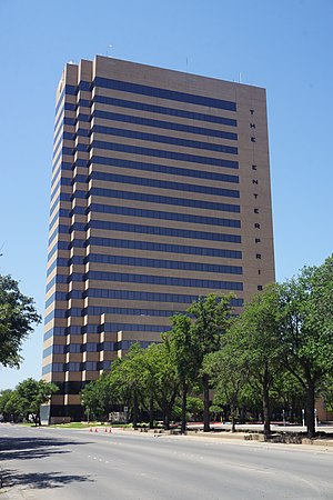
Enterprise Tower
First State Bank Tower and then Bank of America Building
Distance: Approx. 2834 meters
Latitude and longitude: 32.4441473,-99.7352076
The Enterprise is a highrise located in Abilene, Texas originally known as the First State Bank Tower and then Bank of America Building. It was constructed in the early 80s and completed by 1984. This is the tallest building in the city at 20 stories 285 feet (87 m) and 6th tallest in West Texas.
Weather in this IP's area
clear sky
17 Celsius
16 Celsius
16 Celsius
18 Celsius
1019 hPa
75 %
1019 hPa
958 hPa
10000 meters
1.54 m/s
110 degree
07:18:55
19:54:31