Country:
 Germany
Region:
City:
Latitude and Longitude:
Time Zone:
Postal Code:
IP information under different IP Channel
ip-api
Country
Region
City
ASN
Time Zone
ISP
Blacklist
Proxy
Latitude
Longitude
Postal
Route
IPinfo
Country
Region
City
ASN
Time Zone
ISP
Blacklist
Proxy
Latitude
Longitude
Postal
Route
MaxMind
Country
Region
City
ASN
Time Zone
ISP
Blacklist
Proxy
Latitude
Longitude
Postal
Route
Luminati
Country
DEASN
Time Zone
Europe/Berlin
ISP
ENTEGA Medianet GmbH
Latitude
Longitude
Postal
db-ip
Country
Region
City
ASN
Time Zone
ISP
Blacklist
Proxy
Latitude
Longitude
Postal
Route
ipdata
Country
Region
City
ASN
Time Zone
ISP
Blacklist
Proxy
Latitude
Longitude
Postal
Route
Popular places and events near this IP address
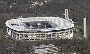
Waldstadion (Frankfurt)
Stadium in Frankfurt am Main, Germany
Distance: Approx. 1854 meters
Latitude and longitude: 50.068056,8.645806
The Waldstadion (German pronunciation: [ˈvalt.ʃtaːdi̯ɔn] , Forest Stadium), currently known as Deutsche Bank Park for sponsorship purposes, is a retractable roof sports stadium in Frankfurt, Hesse, Germany. The home stadium of the football club Eintracht Frankfurt, it was opened in 1925. The stadium has been upgraded several times since then; the most recent remodelling was its redevelopment as a football-only stadium in preparation for the 2005 FIFA Confederations Cup and 2006 FIFA World Cup.

Frankfurt City Forest
Forest district in the south of Frankfurt, Germany
Distance: Approx. 2000 meters
Latitude and longitude: 50.07083333,8.65833333
The Frankfurt City Forest or Frankfurter Stadtwald is a forest district in the south of Frankfurt am Main, Germany. There are also other forest areas spread out through the city.

Frankfurter Kreuz
Road junction
Distance: Approx. 3746 meters
Latitude and longitude: 50.05305556,8.60416667
The Frankfurter Kreuz (Frankfurt Junction) is an Autobahn interchange in Frankfurt am Main, Germany, where the autobahns A3 and A5 meet. The interchange was originally to be built from 1931 to 1933, but due to World War II construction was not finished until 1957. It underwent massive remodeling in the 1990s, as it had been frequently overloaded due to excess traffic.

Neu-Isenburg
Town in Hesse, Germany
Distance: Approx. 3121 meters
Latitude and longitude: 50.05,8.7
Neu-Isenburg is a town in Germany, located in the Offenbach district of Hesse. It is part of the Frankfurt Rhein-Main urban area and has a population of 38,204 (2020). The town is known nowadays mainly for its regionally used shopping centre, the Isenburg-Zentrum (IZ), the Hugenottenhalle, the Hotel Kempinski Frankfurt, the Autokino Gravenbruch (the oldest drive-in cinema in Europe), the Sportpark, the Waldschwimmbad (swimming pool) and its location near Frankfurt Airport.
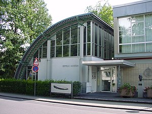
Zeppelin Museum Zeppelinheim
Distance: Approx. 3614 meters
Latitude and longitude: 50.0349,8.6145
Zeppelin Museum Zeppelinheim is located in Neu-Isenburg near Frankfurt am Main. The design of the museum building, constructed in 1988, resembles a quarter section of the hull of the LZ 10. The transport airships Graf Zeppelin and Hindenburg, as well as the second Graf Zeppelin (LZ 130), were based near the present site of the museum, on a site later occupied by the Rhein-Main Air Base.

Frankfurt Stadion station
Railway station in Germany
Distance: Approx. 2381 meters
Latitude and longitude: 50.06805556,8.63305556
Frankfurt am Main Stadion station (German: Bahnhof Frankfurt am Main Stadion) is a junction railway station in Frankfurt, Germany. Stadion station is close to Frankfurt's main football stadium, the Deutsche Bank Park. Prior to 1937 it was called Frankfurt-Goldstein and from then until 24 December 2005 it was called Frankfurt-Sportfeld ("Sport field").

Frankfurt-Niederrad station
Railway halt in Niederrad, Germany
Distance: Approx. 3383 meters
Latitude and longitude: 50.08055556,8.63694444
Frankfurt-Niederrad station is a station in the district of Niederrad in the southwest of Frankfurt am Main in the German state of Hesse.
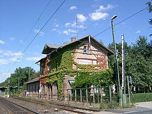
Frankfurt-Louisa station
Railway station in Frankfurt, Germany
Distance: Approx. 3511 meters
Latitude and longitude: 50.083176,8.670337
Frankfurt-Louisa station is a station on the Rhine-Main S-Bahn in the city of Frankfurt in the German state of Hesse. It is also on the Main-Neckar Railway between Frankfurt and Heidelberg.The station is classified by Deutsche Bahn as a category 4 station.

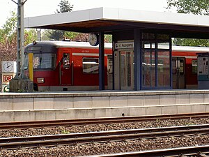
Neu Isenburg station
Railway station in Neu-Isenburg, Germany
Distance: Approx. 662 meters
Latitude and longitude: 50.05277778,8.66583333
Neu-Isenburg station is on the Rhine-Main S-Bahn in Neu-Isenburg in the German state of Hesse. It was opened on 1 November 1852 and is now served by S-Bahn and regional trains operated by Deutsche Bahn. Since 29 May 1961, it has been the only station in Hesse with a loading terminal for motorail trains.
Dreieich-Buchschlag station
Railway station in Dreieich, Germany
Distance: Approx. 3405 meters
Latitude and longitude: 50.0224443,8.6609387
Dreieich-Buchschlag station is a railway station on the Rhine-Main S-Bahn in the town of Dreieich in the German state of Hesse. It was opened in 1879 on the Main-Neckar Railway. The station is classified by Deutsche Bahn as a category 4 station.
1983 Rhein-Main Starfighter crash
Distance: Approx. 1886 meters
Latitude and longitude: 50.06958889,8.65204722
The 1983 Rhein-Main Starfighter crash happened on 22 May 1983, in connection with an air show at the Rhein-Main Air Base. A Canadian Armed Forces Canadair CF-104 Starfighter crashed on a nearby highway, killing six.

KLM Flight 592
1952 aviation accident
Distance: Approx. 2644 meters
Latitude and longitude: 50.07247,8.67753
KLM Flight 592, a KLM Douglas DC-6 was a scheduled passenger flight from Rome-Ciampino Airport (CIA/LIRA) to Frankfurt International Airport (FRA/EDDF). On Saturday 22 March 1952, Flight 592 crashed on final approaching to Frankfurt International around 10:45 AM Local time; 45 of the 47 people aboard the DC-6 were killed.
Weather in this IP's area
few clouds
19 Celsius
20 Celsius
19 Celsius
21 Celsius
1012 hPa
88 %
1012 hPa
998 hPa
10000 meters
2.68 m/s
160 degree
20 %
06:51:19
19:54:59