145.14.6.188 - IP Lookup: Free IP Address Lookup, Postal Code Lookup, IP Location Lookup, IP ASN, Public IP
Country:
Region:
City:
Location:
Time Zone:
Postal Code:
ISP:
ASN:
language:
User-Agent:
Proxy IP:
Blacklist:
IP information under different IP Channel
ip-api
Country
Region
City
ASN
Time Zone
ISP
Blacklist
Proxy
Latitude
Longitude
Postal
Route
db-ip
Country
Region
City
ASN
Time Zone
ISP
Blacklist
Proxy
Latitude
Longitude
Postal
Route
IPinfo
Country
Region
City
ASN
Time Zone
ISP
Blacklist
Proxy
Latitude
Longitude
Postal
Route
IP2Location
145.14.6.188Country
Region
gornja radgona
City
gornja radgona
Time Zone
Europe/Ljubljana
ISP
Language
User-Agent
Latitude
Longitude
Postal
ipdata
Country
Region
City
ASN
Time Zone
ISP
Blacklist
Proxy
Latitude
Longitude
Postal
Route
Popular places and events near this IP address
Bad Radkersburg
Municipality in Styria, Austria
Distance: Approx. 1849 meters
Latitude and longitude: 46.68972222,15.98861111
Bad Radkersburg (German pronunciation: [ˈbaːt ˈʁatkɐsbʊʁk]; Slovene: Radgona; archaic Hungarian: Regede) is a spa town in the southeast of the Austrian state of Styria, in the district of Südoststeiermark.
Gornja Radgona
Town in Styria, Slovenia
Distance: Approx. 217 meters
Latitude and longitude: 46.67523333,15.99260556
Gornja Radgona (pronounced [ˈɡoːɾnja ˈɾaːdɡɔna] ; German: Oberradkersburg, Hungarian: Felsőregede) is a town in Slovenia. It is the seat of the Municipality of Gornja Radgona. Once it was a defensive stronghold for today's regional centre and its twin city, Bad Radkersburg, on the other side of the Mura River in Austria.

Črešnjevci
Village in Styria, Slovenia
Distance: Approx. 2013 meters
Latitude and longitude: 46.65549444,15.99681667
Črešnjevci (pronounced [ˈtʃɾeːʃnjɛu̯tsi], in older sources Črešnjovci, German: Kerschbach) is a dispersed settlement immediately south of Gornja Radgona in northeastern Slovenia. The Slovene author, linguist and beekeeper Peter Dajnko was born in the village in 1787. The house in which he was born is a simple thatched farmhouse and now houses an ethnographic collection.
Hercegovščak
Place in Styria, Slovenia
Distance: Approx. 1126 meters
Latitude and longitude: 46.67446389,15.97756111
Hercegovščak (pronounced [xɛɾˈtseːɡɔu̯ʃtʃak], German: Herzogberg) is a settlement in the hills immediately west of Gornja Radgona in northeastern Slovenia.
Mele, Gornja Radgona
Place in Styria, Slovenia
Distance: Approx. 2816 meters
Latitude and longitude: 46.65840278,16.022
Mele (pronounced [mɛˈleː]; German: Kellerdorf) is a village immediately southeast of Gornja Radgona in northeastern Slovenia. There is a small chapel-shrine in the settlement. It was built in the early 19th century.
Norički Vrh
Place in Styria, Slovenia
Distance: Approx. 744 meters
Latitude and longitude: 46.67171944,15.98273889
Norički Vrh (pronounced [nɔˈɾiːtʃki ˈʋəɾx], German: Fahrenbüchel) is a settlement in the suburbs of Gornja Radgona in northeastern Slovenia. The Kunej Mansion (Slovene: Kunejev dvorec) is a two-story mansion east of the main settlement, first mentioned in written sources dating to the 15th century. It was rebuilt in its current form around 1870 and its landscaped garden dates from 1935.
Orehovski Vrh
Place in Styria, Slovenia
Distance: Approx. 2949 meters
Latitude and longitude: 46.64681111,15.99156389
Orehovski Vrh (pronounced [ɔˈɾeːxɔu̯ski ˈʋəɾx]) is a dispersed settlement in the hills south of Gornja Radgona in northeastern Slovenia.
Podgrad, Gornja Radgona
Place in Styria, Slovenia
Distance: Approx. 1871 meters
Latitude and longitude: 46.68126944,15.970625
Podgrad (pronounced [pɔdˈɡɾáːt, ˈpɔ̀ːdɡɾat]) is a settlement on the right bank of the Mura River in the foothills of Radgona Castle in the Municipality of Gornja Radgona in northeastern Slovenia.
Police, Gornja Radgona
Place in Styria, Slovenia
Distance: Approx. 3012 meters
Latitude and longitude: 46.66403611,15.95515833
Police (pronounced [pɔˈliːtsɛ]) is a dispersed settlement in the hills southwest of Gornja Radgona in northeastern Slovenia.

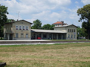
Gornja Radgona railway station
Railway station in Municipality of Gornja Radgona, Slovenia
Distance: Approx. 437 meters
Latitude and longitude: 46.67722222,15.99222222
Gornja Radgona railway station (Slovene: Železniška postaja Gornja Radgona; German: Bahnhof Oberradkersburg) serves the municipality of Gornja Radgona, Slovenia. It was opened on 16 October 1890, as part of the extension of the Radkersburger Bahn from Bad Radkersburg, in present-day Austria, to Ljutomer (then known as Luttenberg), in present-day Slovenia. At the end of World War II, the Radkersburger Bahn was cut at the border between Austria and the then Yugoslavia.

Municipality of Gornja Radgona
Municipality of Slovenia
Distance: Approx. 1002 meters
Latitude and longitude: 46.67,15.98
The Municipality of Gornja Radgona (pronounced [ˈɡoːɾnja ˈɾaːdɡɔna] ; Slovene: Občina Gornja Radgona) is a municipality in Slovenia. The seat of the municipality is the town of Gornja Radgona. It borders Austria.
ŠNK Radgona
Slovenian football club
Distance: Approx. 518 meters
Latitude and longitude: 46.67527778,15.99833333
Športno nogometni klub Radgona (English: Sports Football Club Radgona) or simply ŠNK Radgona is a Slovenian football club from the town of Gornja Radgona. The club was established in 1946 as FD Gornja Radgona and plays its home matches at the Gornja Radgona Stadium, located in the Gornja Radgona Sports Park, with a seating capacity for 301 spectators. Their earliest success dates back to the 1960–61 season when the club won the Pomurska League, the fifth tier of Yugoslav football.
Weather in this IP's area
overcast clouds
8 Celsius
4 Celsius
8 Celsius
8 Celsius
1012 hPa
84 %
1012 hPa
982 hPa
10000 meters
5.47 m/s
10.87 m/s
225 degree
93 %

