Country:
Region:
City:
Latitude and Longitude:
Time Zone:
Postal Code:
IP information under different IP Channel
ip-api
Country
Region
City
ASN
Time Zone
ISP
Blacklist
Proxy
Latitude
Longitude
Postal
Route
Luminati
Country
Region
7
City
sanktjohannintirol
ASN
Time Zone
Europe/Vienna
ISP
Ortswaerme St. Johann in Tirol GmbH
Latitude
Longitude
Postal
IPinfo
Country
Region
City
ASN
Time Zone
ISP
Blacklist
Proxy
Latitude
Longitude
Postal
Route
db-ip
Country
Region
City
ASN
Time Zone
ISP
Blacklist
Proxy
Latitude
Longitude
Postal
Route
ipdata
Country
Region
City
ASN
Time Zone
ISP
Blacklist
Proxy
Latitude
Longitude
Postal
Route
Popular places and events near this IP address
Kitzbühel District
District in Tyrol, Austria
Distance: Approx. 2712 meters
Latitude and longitude: 47.5,12.4
The Bezirk Kitzbühel is an administrative district (Bezirk) in Tyrol, Austria. It borders Bavaria (Germany) in the north, the Kufstein and Schwaz districts in the west, and the Pinzgau region (Salzburg) in the east and south. Area of the district is 1,163.06 km2, population was 61,966 (January 1, 2012), and population density 53 persons per km2.

St. Johann in Tirol
Market town and municipality in Tyrol, Austria
Distance: Approx. 465 meters
Latitude and longitude: 47.5225,12.42555556
Sankt Johann in Tirol, called Sainihåns (German pronunciation: [zãɪ̯nɪ'ɦåns]) in the local dialect, is a market municipality in the Kitzbühel district of Tyrol, Austria. In the regional ductus, the last syllable of the name is stressed as "Sankt yo-Hahn'" (German pronunciation: [zaŋkt joˈhan]).
Oberndorf in Tirol
Place in Tyrol, Austria
Distance: Approx. 3598 meters
Latitude and longitude: 47.49861111,12.38472222
Oberndorf (German: [ˈoːbɐnˌdɔʁf] ) is a municipality in Kitzbühel district in the Austrian state of Tyrol. It is located in the Leukental valley, on the Kitzbühler Ache stream, halfway between St. Johann in Tirol and Kitzbühel.

Kirchdorf in Tirol
Place in Tyrol, Austria
Distance: Approx. 4722 meters
Latitude and longitude: 47.55833333,12.4475
Kirchdorf in Tirol is a municipality in the Kitzbühel district in the Austrian state of Tyrol located 12.2 km (7.6 mi) north of Kitzbühel as well as 3 km (1.9 mi) north of Sankt Johann in Tirol at the Kitzbühler Ache. By area, Kirchdorf is the second largest municipality in the district. The village obtained its name from an old church which was built in the 8th century.

Kitzbüheler Horn
Mountain in the Kitzbühel Alps in Tyrol, Austria
Distance: Approx. 4884 meters
Latitude and longitude: 47.47667,12.43083
The Kitzbüheler Horn (also spelt Kitzbühler Horn) is a mountain in the Kitzbühel Alps in Tyrol, Austria, whose western flank lies near the smart ski resort of Kitzbühel. With a height of 1,996 m (AA) it only just misses being a 'two-thousander'. At the summit is a 102 metre high TV tower belonging to the ORF and known as the Kitzbüheler Horn Transmission Tower (Sendeturm Kitzbüheler Horn).

Maukspitze
Distance: Approx. 6493 meters
Latitude and longitude: 47.55944,12.35694
The Maukspitze is a mountain peak in the Kaisergebirge range of the Northern Limestone Alps. It is 2,231 meters above the Adriatic, making it the ninth tallest peak in the Kaisergebirge.

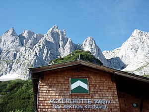
Ackerl Hut
Alpine club hut in Austria
Distance: Approx. 6814 meters
Latitude and longitude: 47.54944,12.34111
The Ackerl Hut (German: Ackerlhütte) is an Alpine club hut in the Wilder Kaiser mountains in Austria. It is run by the Kitzbühel section of the Austrian Alpine Club and lies at a height of 1,455 metres (4,774 ft) (according to other sources 1,456 m or 1,465 m) below the south faces of the Regalmspitze, Ackerlspitze and Maukspitze.

Leukental
Distance: Approx. 3356 meters
Latitude and longitude: 47.54583333,12.44361111
The Leukental is a valley in North Tyrol in the district of Kitzbühel in Austria. The Leukental runs north to south from the Thurn Pass to the Bavarian border, but is not just defined as the main valley but includes several smaller side valleys. The river flowing through the Leukental is known as the Jochberger Ache from its source at the Thurn Pass to Kitzbühel, then as the Kitzbühler Ache from Kitzbühel to St.
Schleierfall
Waterfall in Austria
Distance: Approx. 5211 meters
Latitude and longitude: 47.545398,12.362355
The Schleier Waterfall or Schleierfall, also called the Schleier, is a waterfall on the Rettenbach stream on the southern side of the Gamskögerl (1,586 m above sea level (AA)) in the Wilder Kaiser mountains of Austria. It is located within the district of Kitzbühel. From the waterfall the Rettenbach forms the boundary between the parishes of Going am Wilden Kaiser and St.

Kitzbüheler Horn Transmitter
Distance: Approx. 4952 meters
Latitude and longitude: 47.47595,12.4298
The Kitzbüheler Horn Transmitter (German: Sender Kitzbüheler Horn) is a 102-metre-high (335 ft) transmission tower made of reinforced concrete on the summit of the Kitzbüheler Horn near Kitzbühel in Austria. The Kitzbühler Horn Transmitter does not have a cylindrical shaft. It broadcasts TV and VHF radio programmes.

Sankt Johann Airfield
Airport in Austria
Distance: Approx. 2162 meters
Latitude and longitude: 47.52030556,12.44936111
Sankt Johann Airfield (German: Flugplatz Sankt Johann, ICAO: LOIJ) is a recreational aerodrome located 1 kilometre (1 mi) east of Sankt Johann in Tirol, Tyrol, Austria.
Sankt Johann in Tirol Heliport
Airport in Austria
Distance: Approx. 683 meters
Latitude and longitude: 47.52088889,12.42958333
Sankt Johann in Tirol Heliport (ICAO: LOIT) is a public use heliport located in Sankt Johann in Tirol, Tirol, Austria.
Weather in this IP's area
clear sky
12 Celsius
10 Celsius
12 Celsius
12 Celsius
1026 hPa
45 %
1026 hPa
948 hPa
10000 meters
0.44 m/s
0.99 m/s
126 degree
3 %
07:05:07
16:43:07
