Country:
 Netherlands
Region:
City:
Latitude and Longitude:
Time Zone:
Postal Code:
IP information under different IP Channel
ip-api
Country
Region
City
ASN
Time Zone
ISP
Blacklist
Proxy
Latitude
Longitude
Postal
Route
IPinfo
Country
Region
City
ASN
Time Zone
ISP
Blacklist
Proxy
Latitude
Longitude
Postal
Route
MaxMind
Country
Region
City
ASN
Time Zone
ISP
Blacklist
Proxy
Latitude
Longitude
Postal
Route
Luminati
Country
NLRegion
li
City
maastricht
ASN
Time Zone
Europe/Amsterdam
ISP
SURF B.V.
Latitude
Longitude
Postal
db-ip
Country
Region
City
ASN
Time Zone
ISP
Blacklist
Proxy
Latitude
Longitude
Postal
Route
ipdata
Country
Region
City
ASN
Time Zone
ISP
Blacklist
Proxy
Latitude
Longitude
Postal
Route
Popular places and events near this IP address

Maastricht
City and municipality in Limburg, Netherlands
Distance: Approx. 2248 meters
Latitude and longitude: 50.85,5.68333333
Maastricht ( MAH-strikht, US also mah-STRIKHT, Dutch: [maːˈstrɪxt] ; Limburgish: Mestreech [məˈstʀeːx]; French: Maestricht (archaic); Spanish: Mastrique (archaic)) is a city and a municipality in the southeastern Netherlands. It is the capital and largest city of the province of Limburg. Maastricht is located on both sides of the Meuse (Dutch: Maas), at the point where the river is joined by the Jeker.
Veldwezelt-Hezerwater
Archaeological site in Lanaken, Belgium
Distance: Approx. 823 meters
Latitude and longitude: 50.856,5.641
Veldwezelt-Hezerwater is a Palaeolithic archaeological site in the municipality of Lanaken in the province of Limburg, Belgium.
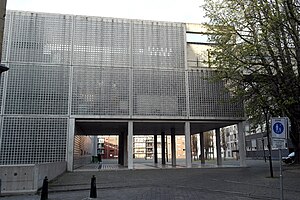
Maastricht Institute of Arts
Art school based in Maastricht, the Netherlands
Distance: Approx. 2251 meters
Latitude and longitude: 50.8487,5.683
Maastricht Institute of Arts, formerly known as the Academie Beeldende Kunsten Maastricht (Maastricht Academy of Fine Arts and Design) and the Stadsacademie voor Toegepaste Kunsten (City Academy of Applied Arts), is a cluster of visual arts education from Zuyd University of Applied Sciences in Maastricht. The institute offers higher education in Bachelor of Education, Fine Arts and Design, Communication Design, Architecture and Interior Design, Interdisciplinary Arts, and in Master of Scientific Illustration, Architecture and Interior Design. Since 2020, the institute, in cooperation with the Academies of Music and Theatre, the Jan van Eyck Academy and Maastricht University, has offered the possibility of a doctorate in the visual arts.
Oud-Vroenhoven
Distance: Approx. 2193 meters
Latitude and longitude: 50.83333333,5.65
Oud-Vroenhoven is former municipality in the Dutch province of Limburg. It merged with Maastricht in 1920. The municipality covered a large part of the current municipality of Maastricht west of the river Meuse outside the walls of the city.

Battle of Maastricht
Distance: Approx. 2246 meters
Latitude and longitude: 50.85,5.6833
The Battle of Maastricht was one of the first battles that took place during the German Campaign on the Western Front during World War II. Maastricht was a key city in order to capture the Belgian Fort Eben-Emael and split the allied armies in half.
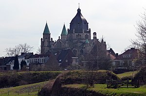
Sint-Lambertuskerk (Maastricht)
Distance: Approx. 1811 meters
Latitude and longitude: 50.84972222,5.67694444
The Sint-Lambertuskerk (St. Lambert's) is a former church in the city of Maastricht, Limburg, Netherlands. At the time of its completion in 1916, St.

Siege of Maastricht (1748)
Part of the War of Austrian Succession
Distance: Approx. 1849 meters
Latitude and longitude: 50.86666667,5.66666667
The siege of Maastricht took place in April–May 1748 during the War of the Austrian Succession. A French force under the overall command of Maurice de Saxe besieged and captured the Dutch barrier fortress of Maastricht in the final few months of the campaign in the Low Countries. After a relatively long siege the garrison of Maastricht capitulated and marched out with the honours of war.

Biesland (Maastricht)
Nayberhood in Limburg, Maastricht
Distance: Approx. 2078 meters
Latitude and longitude: 50.8406,5.6738
Biesland is a neighbourhood of Maastricht, Netherlands located in the southwest of the city. It is mainly a residential neighbourhood and relatively affluent.
Chez Jacques
Restaurant in Maastricht, Netherlands
Distance: Approx. 2380 meters
Latitude and longitude: 50.84956667,5.685125
Bistro Chez Jacques is a defunct restaurant in Maastricht, Netherlands. It was a fine dining restaurant that was awarded one Michelin star in 1976 and retained that rating until 1979. Its owner and head chef was Jacques Zeguers.

Siege of Maastricht (1793)
Siege of the War of the First Coalition
Distance: Approx. 1795 meters
Latitude and longitude: 50.8525,5.67722222
The siege of Maastricht was a failed siege of the city of Maastricht by the forces of the French First Republic from 6 February to 2 March 1793, marking the final action of the 1793 campaign of the War of the First Coalition. The city was successfully defended by the Dutch garrison with the assistance of a small band of French Royalists.

Crosier Monastery, Maastricht
Distance: Approx. 2314 meters
Latitude and longitude: 50.84861111,5.68388889
The Crosier Monastery or Monastery of the Crutched Friars (Dutch: Kruisherenklooster) is a former monastery of the Order of the Holy Cross in Maastricht, Netherlands. The well-preserved convent buildings house a five-star hotel, the Kruisherenhotel. Having survived more or less in its entirety, it is a rare example in the Netherlands of a Gothic monastery.

Siege of Maastricht (1794)
Siege of the War of the First Coalition
Distance: Approx. 2248 meters
Latitude and longitude: 50.85,5.68333333
The siege of Maastricht (22 September – 4 November 1794) was a successful siege of the city of Maastricht by the forces of the French First Republic led by General of Division (GD) Jean-Baptiste Kléber. The War of the First Coalition action resulted in the surrender of the Coalition garrison commanded by Lieutenant General Prince Frederick of Hesse-Kassel. The defenders were mostly Habsburg Austrians with a smaller contingent of Dutch Republic soldiers.
Weather in this IP's area
clear sky
20 Celsius
20 Celsius
19 Celsius
22 Celsius
1010 hPa
68 %
1010 hPa
1001 hPa
10000 meters
2.24 m/s
4.92 m/s
36 degree
07:02:29
20:07:51