Country:
 Netherlands
Region:
City:
Latitude and Longitude:
Time Zone:
Postal Code:
IP information under different IP Channel
ip-api
Country
Region
City
ASN
Time Zone
ISP
Blacklist
Proxy
Latitude
Longitude
Postal
Route
IPinfo
Country
Region
City
ASN
Time Zone
ISP
Blacklist
Proxy
Latitude
Longitude
Postal
Route
MaxMind
Country
Region
City
ASN
Time Zone
ISP
Blacklist
Proxy
Latitude
Longitude
Postal
Route
Luminati
Country
NLRegion
li
City
maastricht
ASN
Time Zone
Europe/Amsterdam
ISP
SURF B.V.
Latitude
Longitude
Postal
db-ip
Country
Region
City
ASN
Time Zone
ISP
Blacklist
Proxy
Latitude
Longitude
Postal
Route
ipdata
Country
Region
City
ASN
Time Zone
ISP
Blacklist
Proxy
Latitude
Longitude
Postal
Route
Popular places and events near this IP address

Onze Lieve Vrouweplein
Square in Maastricht, the Netherlands
Distance: Approx. 394 meters
Latitude and longitude: 50.8475,5.693
The Onze Lieve Vrouweplein (Dutch: [ˌɔnzə ˌlivə ˈvrʌu.əˌplɛin]; Limburgish: Slevrouweplein [sləˈvʀɔwəˌplɛːn˦]; "Square of Our Lady") is a square in the historic center of Maastricht, the Netherlands. The square is situated south of Maastricht's pedestrianised shopping district. Well known for its many café terraces, it is a popular place with tourists and local people alike.
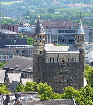
Basilica of Our Lady, Maastricht
Roman Catholic church in Maastricht, Netherlands
Distance: Approx. 378 meters
Latitude and longitude: 50.8475,5.69361111
The Basilica of Our Lady (Dutch: Basiliek van Onze-Lieve-Vrouw; Limburgish: Slevrouwe [sləˈvʀɔwə]) is a Romanesque church in the historic center of Maastricht, Netherlands. The church is dedicated to Our Lady of the Assumption (Dutch: Onze-Lieve-Vrouw-Tenhemelopneming) and is a Roman Catholic parish church in the Diocese of Roermond. The church is often referred to as the Star of the Sea (Dutch: Sterre der Zee), after the church's main devotion, Our Lady, Star of the Sea.

Fotomuseum aan het Vrijthof
Distance: Approx. 528 meters
Latitude and longitude: 50.84833333,5.68888889
The Fotomuseum aan het Vrijthof (previously: Museum aan het Vrijthof and Museum Spaans Gouvernement) is a museum of photography in Maastricht, Netherlands.
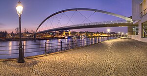
Sint Servaasbrug
Bridge in Maastricht, Netherlands
Distance: Approx. 173 meters
Latitude and longitude: 50.84916667,5.69583333
Sint Servaasbrug (or the St. Servatius Bridge) is an arched stone cyclist and pedestrian bridge across the river Meuse in Maastricht, Netherlands. It is named after Saint Servatius, the first bishop of Maastricht, and (despite being largely rebuilt after World War II) it has been called the oldest bridge in the Netherlands.

Toine Hermsen (restaurant)
Restaurant in Maastricht, Netherlands
Distance: Approx. 432 meters
Latitude and longitude: 50.84690278,5.69410278
Toine Hermsen is a restaurant located in Maastricht in the Netherlands. It is a fine dining restaurant that was awarded one or two Michelin stars from 1993 to present. GaultMillau awarded the restaurant 16.0 out of 20 points.
Wyck, Maastricht
Neighbourhood in Maastricht, Netherlands
Distance: Approx. 481 meters
Latitude and longitude: 50.84944444,5.70194444
Wyck (Dutch: [ʋik]; Limburgish: Wiek [wiːk˦]) is a neighbourhood in Maastricht, Netherlands, comprising the eastern bank of the Meuse (Dutch: Maas) in the city's historic centre.

Binnenstad, Maastricht
Neighborhood of Maastricht in Netherlands, Limburg
Distance: Approx. 461 meters
Latitude and longitude: 50.8498,5.689
Binnenstad (Dutch pronunciation: [ˈbɪnə(n)ˌstɑt]; Limburgish: Binnestad [ˈbɪnəˌstɑt]; English: Inner city) is a neighbourhood in Maastricht, Netherlands. Until 2007, it was officially named City. As its name suggests, it is the most centrally located area of Maastricht.
Hoge Brug
Bridge in Maastricht, Netherlands
Distance: Approx. 518 meters
Latitude and longitude: 50.8462,5.6973
The Hoge Brug (pronounced [ˈɦoːɣə ˈbrʏx]; Dutch for 'high bridge'), also known by its Maastrichtian dialect name Hoeg Brögk (pronounced [ɦuɣ ˈbʀœk]), is a pedestrian and cycle bridge that spans the Meuse (Dutch: Maas) in Maastricht, Netherlands.
Tout à Fait
Restaurant in Maastricht, Netherlands
Distance: Approx. 486 meters
Latitude and longitude: 50.84640833,5.69415278
Restaurant Rotisserie Tout à Fait is a restaurant in Maastricht, Netherlands. It is a fine dining restaurant that was awarded one Michelin star in 2002 and retained that rating until present. In 2013, GaultMillau awarded the restaurant 16 out of 20 points.
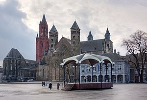
Vrijthof
Square in Maastricht, the Netherlands
Distance: Approx. 519 meters
Latitude and longitude: 50.849172,5.688419
Vrijthof is a large urban square in the centre of Maastricht, Netherlands. The square developed from an ancient Roman and Frankish cemetery into a semi-private space that belonged to the Collegiate Church of Saint Servatius. In the 19th century, it became the town's main square.

Maastricht City Hall
City hall in Maastricht, The Netherlands
Distance: Approx. 289 meters
Latitude and longitude: 50.85134,5.69141
The Stadhuis is the historic town hall in the centre of Maastricht in the Netherlands. It is sited on the Markt square an open-air marketplace. The building was designed by the Dutch Gold Age architect and painter Pieter Post in the 17th century in the style of Dutch classicism.
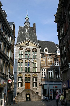
Dinghuis
Government building in Maastricht
Distance: Approx. 214 meters
Latitude and longitude: 50.84989,5.69264
The Dinghuis (Ding House) is a building in downtown Maastricht, Netherlands, constructed at the end of the 15th century. (Ding is the Dutch name for the governing assembly known in most Germanic languages as a thing.) The building was constructed in the gothic style of architecture. The northern façade, built around 1470, is timber-framed, and the main façade, built of Namur stone, has a pediment containing a grand clock face.
Weather in this IP's area
fog
16 Celsius
16 Celsius
15 Celsius
16 Celsius
1013 hPa
94 %
1013 hPa
1007 hPa
650 meters
1.54 m/s
180 degree
75 %
08:07:11
18:36:44