Country:
 Switzerland
Region:
City:
Latitude and Longitude:
Time Zone:
Postal Code:
IP information under different IP Channel
ip-api
Country
Region
City
ASN
Time Zone
ISP
Blacklist
Proxy
Latitude
Longitude
Postal
Route
IPinfo
Country
Region
City
ASN
Time Zone
ISP
Blacklist
Proxy
Latitude
Longitude
Postal
Route
MaxMind
Country
Region
City
ASN
Time Zone
ISP
Blacklist
Proxy
Latitude
Longitude
Postal
Route
Luminati
Country
CHRegion
vd
City
chamblon
ASN
Time Zone
Europe/Zurich
ISP
VTX Services SA
Latitude
Longitude
Postal
db-ip
Country
Region
City
ASN
Time Zone
ISP
Blacklist
Proxy
Latitude
Longitude
Postal
Route
ipdata
Country
Region
City
ASN
Time Zone
ISP
Blacklist
Proxy
Latitude
Longitude
Postal
Route
Popular places and events near this IP address

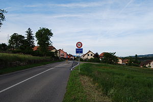
Chamblon
Municipality in Vaud, Switzerland
Distance: Approx. 447 meters
Latitude and longitude: 46.78333333,6.6
Chamblon is a municipality in the district of Jura-Nord Vaudois of the canton of Vaud in Switzerland.

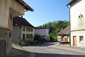
Montagny-près-Yverdon
Municipality in Vaud, Switzerland
Distance: Approx. 1258 meters
Latitude and longitude: 46.78333333,6.61666667
Montagny-près-Yverdon is a municipality in the district of Jura-Nord Vaudois of the canton of Vaud in Switzerland.

Suscévaz
Municipality in Vaud, Switzerland
Distance: Approx. 1966 meters
Latitude and longitude: 46.76666667,6.58333333
Suscévaz is a municipality in the district of Jura-Nord Vaudois of the canton of Vaud in Switzerland.
Treycovagnes
Municipality in Vaud, Switzerland
Distance: Approx. 1420 meters
Latitude and longitude: 46.76666667,6.6
Treycovagnes is a municipality in the district of Jura-Nord Vaudois of the canton of Vaud in Switzerland.
Valeyres-sous-Montagny
Municipality in Vaud, Switzerland
Distance: Approx. 2295 meters
Latitude and longitude: 46.8,6.6
Valeyres-sous-Montagny is a municipality in the district of Jura-Nord Vaudois of the canton of Vaud in Switzerland.

Villars-sous-Champvent
Former municipality in Vaud, Switzerland
Distance: Approx. 1431 meters
Latitude and longitude: 46.78333333,6.58333333
Villars-sous-Champvent was a former municipality in the district of Jura-Nord Vaudois of the canton of Vaud in Switzerland. The municipalities of Essert-sous-Champvent and Villars-sous-Champvent merged on 1 January 2012 into the municipality of Champvent.

Yverdon District
District in Switzerland
Distance: Approx. 2488 meters
Latitude and longitude: 46.78333333,6.63333333
Yverdon District was a district of the canton of Vaud in Switzerland until 2006 when it was dissolved. It was divided into the Cercles of Molondin, Belmont-sur-Yverdon, Yverdon and Champvent. The district consisted of 38 municipalities, is 156.68 km2 in area and was home to 34,929 inhabitants at the end of 2003.
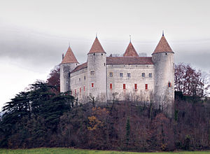
Champvent Castle
Castle in Champvent, Switzerland
Distance: Approx. 2285 meters
Latitude and longitude: 46.778955,6.571238
Champvent Castle is a castle in the municipality of Champvent of the Canton of Vaud in Switzerland. It is a Swiss heritage site of national significance.

Yverdon William Barbey railway station
Railway station in Yverdon-les-Bains, Switzerland
Distance: Approx. 2571 meters
Latitude and longitude: 46.78888889,6.63194444
Yverdon William Barbey railway station (French: Gare de Yverdon William Barbey) is a railway station in the municipality of Yverdon-les-Bains, in the Swiss canton of Vaud. It is an intermediate stop and a request stop on the 1,000 mm (3 ft 3+3⁄8 in) gauge Yverdon–Ste-Croix line of Travys.
La Brinaz railway station
Railway station in Montagny-près-Yverdon, Switzerland
Distance: Approx. 2158 meters
Latitude and longitude: 46.79388889,6.62
La Brinaz railway station (French: Gare de La Brinaz) is a railway station in the municipality of Montagny-près-Yverdon, in the Swiss canton of Vaud. It is an intermediate stop and a request stop on the 1,000 mm (3 ft 3+3⁄8 in) gauge Yverdon–Ste-Croix line of Travys.
Valeyres-sous-Montagny railway station
Railway station in Valeyres-sous-Montagny, Switzerland
Distance: Approx. 2094 meters
Latitude and longitude: 46.79694444,6.61111111
Valeyres-sous-Montagny railway station (French: Gare de Valeyres-sous-Montagny) is a railway station in the municipality of Valeyres-sous-Montagny, in the Swiss canton of Vaud. It is an intermediate stop and a request stop on the 1,000 mm (3 ft 3+3⁄8 in) gauge Yverdon–Ste-Croix line of Travys.

Essert-sous-Champvent railway station
Railway station in Champvent, Switzerland
Distance: Approx. 2372 meters
Latitude and longitude: 46.795,6.58
Essert-sous-Champvent railway station (French: Gare de Essert-sous-Champvent) is a railway station in the municipality of Champvent, in the Swiss canton of Vaud. It is an intermediate stop and a request stop on the 1,000 mm (3 ft 3+3⁄8 in) gauge Yverdon–Ste-Croix line of Travys.
Weather in this IP's area
broken clouds
12 Celsius
12 Celsius
12 Celsius
12 Celsius
1009 hPa
96 %
1009 hPa
948 hPa
10000 meters
1.95 m/s
3.59 m/s
205 degree
84 %
07:40:30
19:01:53