Country:
 The Philippines
Region:
City:
Latitude and Longitude:
Time Zone:
Postal Code:
IP information under different IP Channel
ip-api
Country
Region
City
ASN
Time Zone
ISP
Blacklist
Proxy
Latitude
Longitude
Postal
Route
IPinfo
Country
Region
City
ASN
Time Zone
ISP
Blacklist
Proxy
Latitude
Longitude
Postal
Route
MaxMind
Country
Region
City
ASN
Time Zone
ISP
Blacklist
Proxy
Latitude
Longitude
Postal
Route
Luminati
Country
PHASN
Time Zone
Asia/Manila
ISP
NewMountainView Satellite Corporation
Latitude
Longitude
Postal
db-ip
Country
Region
City
ASN
Time Zone
ISP
Blacklist
Proxy
Latitude
Longitude
Postal
Route
ipdata
Country
Region
City
ASN
Time Zone
ISP
Blacklist
Proxy
Latitude
Longitude
Postal
Route
Popular places and events near this IP address
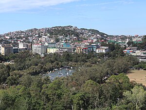
Baguio
Largest highly urbanized city in Benguet, Philippines
Distance: Approx. 1149 meters
Latitude and longitude: 16.4119,120.5933
Baguio (UK: BAG-ee-oh, US: BAH-ghee-oh, -OH, Tagalog: [ˈbaɡjo]), officially the City of Baguio (Ibaloi: Siudad ne Bagiw; Ilocano: Siudad ti Baguio; Tagalog: Lungsod ng Baguio), is a 1st class highly urbanized city in the Cordillera Administrative Region, Philippines. It is known as the "Summer Capital of the Philippines", owing to its cool climate since the city is located approximately 4,810 feet (1,470 meters) above mean sea level, often cited as 1,540 meters (5,050 feet) in the Luzon tropical pine forests ecoregion, which also makes it conducive for the growth of mossy plants, orchids and pine trees, to which it attributes its other moniker as the "City of Pines". Baguio was established as a hill station by the United States in 1900 at the site of an Ibaloi village known as Kafagway.
Mount Mirador
Mountain in Baguio, Philippines
Distance: Approx. 869 meters
Latitude and longitude: 16.4167,120.5832
Mount Mirador is a mountain situated in the city of Baguio in the Cordillera Central mountain range, Luzon Island in the Philippines. A meteorological station was established in September 1909 and was the second highest station during that time with the first being the meteorological station in Mount Fuji. Said station was also equipped with a time ball and a typhoon signal for the benefit of Baguio city.
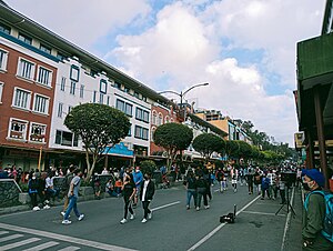
Session Road
Road in Baguio, Philippines
Distance: Approx. 1613 meters
Latitude and longitude: 16.41239,120.59766
Session Road is a six-lane 1.7-kilometer (1.1 mi) major road in Baguio, Philippines. The entire road forms part of National Route 231 (N231) of the Philippine highway network.

Burnham Park (Baguio)
Historic park at Baguio, Philippines
Distance: Approx. 1568 meters
Latitude and longitude: 16.40666667,120.5975
Burnham Park, officially known as the Burnham Park Reservation, is a historic urban park located in downtown Baguio, Philippines. It was designed by eponymous American architect and Baguio city planner, Daniel Burnham.
University of the Cordilleras
Private university in Benguet, Philippines
Distance: Approx. 1596 meters
Latitude and longitude: 16.40845,120.59794
The University of the Cordilleras (UC or UC-BCF; Filipino: Unibersidad ng Kordilyeras), formerly known as the Baguio Colleges Foundation (BCF), is a private coeducational university in Baguio, Philippines. Founded by Benjamin R. Salvosa and his wife Evangelina D. Salvosa in 1946, it offers programs at the elementary, secondary, undergraduate and graduate levels catering to around 21,000 students. It has three campuses all located in Baguio.

Baguio City National High School
Public high school in Baguio, Philippines
Distance: Approx. 1525 meters
Latitude and longitude: 16.40701,120.59714
The first secondary school in Baguio, Philippines was the normal school in 1916 later called Baguio Trade School. Classes were held where Home Sweet Home now stands as this area and the present University of the Philippines Baguio location was included in the reserved land for the Bureau of Education by Forbes. In 1919 it became Mountain Province High School.

Baguio Cemetery
Public cemetery in Baguio, Philippines
Distance: Approx. 915 meters
Latitude and longitude: 16.4116,120.57491
Baguio Cemetery (also known as the Baguio Public Cemetery) is a 94,800-square-meter (23.4-acre) cemetery in the city of Baguio, Philippines, on top of a hill along Naguilian Road. Established in the 1950s, the cemetery was overcrowded by 2011. Informal settlers, some working in the cemetery as tomb cleaners and painters, have settled in land allotted to the cemetery by the Baguio city government.
Pines City National High School
Public high school in Baguio. Philippines
Distance: Approx. 878 meters
Latitude and longitude: 16.41362,120.58959
Pines City National High School is a public secondary school in Baguio, Philippines. It has a main campus (located on Palma Street), and several annexes and campuses in the city.

University of the Philippines Baguio
Public university in Baguio, Philippines
Distance: Approx. 1648 meters
Latitude and longitude: 16.405145,120.597932
The University of the Philippines Baguio (UPB; Filipino: Unibersidad ng Pilipinas Baguio), also referred to as UP in the North or UP Baguio, is a public research university located in Baguio, Philippines. It was established in 1921 through the initiative of UP alumni in Baguio and Benguet and was inaugurated as the University of the Philippines College Baguio on April 22, 1961. It was eventually elevated to its present autonomous status as a constituent university on December 2, 2002.

Baguio Athletic Bowl
Sports complex in Baguio, Philippines
Distance: Approx. 1376 meters
Latitude and longitude: 16.40777778,120.59583333
The Baguio Athletic Bowl is a 7-hectare sports complex within the grounds of Burnham Park in Baguio, Philippines. Completed in 1945, it is currently undergoing renovation work.

Baguio General Hospital
Government hospital in Baguio, Philippines
Distance: Approx. 1637 meters
Latitude and longitude: 16.4011,120.596
Baguio General Hospital and Medical Center (BGHMC), also known as Baguio General Hospital (BGH), is a hospital in Baguio, Philippines. It is the largest government funded tertiary hospital in the Northern Luzon Region.

Maharlika Livelihood Center
Shopping mall in Baguio, Philippines
Distance: Approx. 1393 meters
Latitude and longitude: 16.41406,120.59488
Maharlika Livelihood Center is a shopping complex in Baguio, Philippines.
Weather in this IP's area
broken clouds
17 Celsius
17 Celsius
17 Celsius
17 Celsius
1013 hPa
92 %
1013 hPa
853 hPa
10000 meters
1.64 m/s
1.6 m/s
81 degree
78 %
05:50:52
17:34:04