Country:
 Austria
Region:
City:
Latitude and Longitude:
Time Zone:
Postal Code:
IP information under different IP Channel
ip-api
Country
Region
City
ASN
Time Zone
ISP
Blacklist
Proxy
Latitude
Longitude
Postal
Route
IPinfo
Country
Region
City
ASN
Time Zone
ISP
Blacklist
Proxy
Latitude
Longitude
Postal
Route
MaxMind
Country
Region
City
ASN
Time Zone
ISP
Blacklist
Proxy
Latitude
Longitude
Postal
Route
Luminati
Country
 US
USASN
Time Zone
America/Chicago
ISP
Accenture UK Limited
Latitude
Longitude
Postal
db-ip
Country
Region
City
ASN
Time Zone
ISP
Blacklist
Proxy
Latitude
Longitude
Postal
Route
ipdata
Country
Region
City
ASN
Time Zone
ISP
Blacklist
Proxy
Latitude
Longitude
Postal
Route
Popular places and events near this IP address

Vienna
Capital and largest city of Austria
Distance: Approx. 93 meters
Latitude and longitude: 48.20833333,16.3725
Vienna ( vee-EN-ə; German: Wien [viːn] ; Austro-Bavarian: Wean [veɐ̯n]) is the capital, most populous city, and one of nine federal states of Austria. It is Austria's primate city, with just over two million inhabitants. Its larger metropolitan area has a population of nearly 2.9 million, representing nearly one-third of the country's population.
Vergilius Chapel
Underground crypt in Vienna, Austria
Distance: Approx. 70 meters
Latitude and longitude: 48.2083,16.3722
The Vergilius Chapel (German: Virgilkapelle) is an underground crypt next to the Stephansdom in Vienna. It is rectangular in form (approximately 6 meters by 10), with six niches. Today, it lies approximately 12 meters beneath the Stephansplatz.

Ducal Crypt, Vienna
Burial chamber beneath the chancel of Stephansdom in Vienna, Austria
Distance: Approx. 113 meters
Latitude and longitude: 48.20833,16.37278
The Ducal Crypt (German: Herzogsgruft) is a burial chamber beneath the chancel of Stephansdom in Vienna, Austria. It holds 78 containers with the bodies, hearts, or viscera of 72 members of the House of Habsburg.

Palais Bartolotti-Partenfeld
Distance: Approx. 117 meters
Latitude and longitude: 48.20805556,16.36972222
The Palais Bartolotti-Partenfeld is a city-palace in central Vienna's 1st district, Inner City, on the corner of Graben and Dorotheergasse. It was originally built for the Bartolotti noble family and later bought by the Partenfeld family.

Church of the Teutonic Order, Vienna
Distance: Approx. 128 meters
Latitude and longitude: 48.2075,16.37277778
The Church of the Teutonic Order (German: Deutschordenskirche), also known as the Church of Saint Elisabeth of Hungary (German: Hl. Elisabeth von Ungarn), is the mother church of the Teutonic Order, a German-based Roman Catholic religious order formed at the end of the 12th century. Located in Vienna, Austria, near the Stephansdom, it is the current seat of the Grand Master of the Order.

Stephansplatz, Vienna
Square in Vienna, Austria
Distance: Approx. 94 meters
Latitude and longitude: 48.20841667,16.37247222
The Stephansplatz is a square at the geographical centre of Vienna, Austria. It is named after its most prominent building, the Stephansdom, Vienna's cathedral and one of the tallest churches in the world. Before the 20th century, a row of houses separated Stephansplatz from Stock-im-Eisen-Platz, but since their destruction, the name Stephansplatz started to be used for the wider area covering both.

Haas House
Building in Vienna, Austria
Distance: Approx. 25 meters
Latitude and longitude: 48.208,16.371
The Haas House is a building in Vienna, Austria, at the Stock-im-Eisen-Platz. Designed by the Austrian architect Hans Hollein, it is a building in the postmodernist style and was completed in 1990. The building is located at the site of the former Philipp Haas & Söhne flagship department store dating to 1867, destroyed during World War II and rebuilt in 1953.

Stock im Eisen
Monument in Vienna, Austria
Distance: Approx. 37 meters
Latitude and longitude: 48.2079,16.3717
The Stock im Eisen (German: "staff in iron") is the midsection of a tree-trunk from the Middle Ages, a so-called nail-tree (Nagelbaum), into which hundreds of nails have been pounded for good luck over centuries. It is located in Vienna, Austria, in Stock-im-Eisen-Platz, now part of Stephansplatz, at the corner of the Graben and Kärntner Straße and is now behind glass on a corner of the Palais Equitable.

Stephansplatz station (Vienna U-Bahn)
Vienna U-Bahn station
Distance: Approx. 28 meters
Latitude and longitude: 48.20805556,16.37166667
Stephansplatz is an important destination and interchange station in the Vienna U-Bahn system. It is located under the Stephansplatz and is served by lines U1 and U3. It is located in the Innere Stadt district.
Palais Equitable
Distance: Approx. 28 meters
Latitude and longitude: 48.20805556,16.37166667
The Palais Equitable is an office building in Stock-im-Eisen-Platz (now part of Stephansplatz) in the Innere Stadt of Vienna, Austria, that was built in the 19th century for The Equitable Life Assurance Society of the United States and that incorporates a Stock im Eisen on one corner. The building is on the site of five small medieval buildings that were demolished between 1856 and 1886, partly in order to expand Kärntner Straße. It was designed by Andreas Streit and constructed between 1887 and 1891.

Trams in Vienna
Overview of the tram system of Vienna, Austria
Distance: Approx. 92 meters
Latitude and longitude: 48.20816667,16.37253611
Trams in Vienna (German: Wiener Straßenbahn, in everyday speech also Bim or Tramway) are a vital part of the public transport system in Vienna, capital city of Austria. In operation since 1865, with the completion of a 2 km (1.2 mi) route to industrial estates near Simmering, it reached its maximum extent of 292 km (181.4 mi) in 1942. In February 2015, it was the fifth largest tram network in the world, at about 176.9 kilometres (109.9 mi) in total length and 1,071 stations.
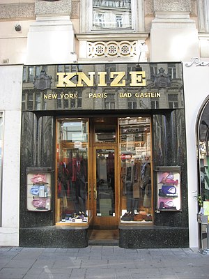
Kniže & Comp.
Clothing store in Innere Stadt, Austria
Distance: Approx. 125 meters
Latitude and longitude: 48.2085,16.36972222
Kniže & Comp. is a men's outfitter from Vienna, considered the first men's fashion brand in the world. The first men's fragrance series "Knize Ten" was also created by the traditional house.
Weather in this IP's area
few clouds
14 Celsius
13 Celsius
12 Celsius
15 Celsius
1010 hPa
84 %
1010 hPa
988 hPa
10000 meters
0.89 m/s
2.24 m/s
202 degree
12 %
07:02:30
18:21:45