Country:
 Ireland
Region:
City:
Latitude and Longitude:
Time Zone:
Postal Code:
IP information under different IP Channel
ip-api
Country
Region
City
ASN
Time Zone
ISP
Blacklist
Proxy
Latitude
Longitude
Postal
Route
IPinfo
Country
Region
City
ASN
Time Zone
ISP
Blacklist
Proxy
Latitude
Longitude
Postal
Route
MaxMind
Country
Region
City
ASN
Time Zone
ISP
Blacklist
Proxy
Latitude
Longitude
Postal
Route
Luminati
Country
 NL
NLASN
Time Zone
Europe/Amsterdam
ISP
OVH SAS
Latitude
Longitude
Postal
db-ip
Country
Region
City
ASN
Time Zone
ISP
Blacklist
Proxy
Latitude
Longitude
Postal
Route
ipdata
Country
Region
City
ASN
Time Zone
ISP
Blacklist
Proxy
Latitude
Longitude
Postal
Route
Popular places and events near this IP address

Dublin
Capital and largest city of Ireland
Distance: Approx. 22 meters
Latitude and longitude: 53.35,-6.26027778
Dublin ( ; Irish: Baile Átha Cliath, pronounced [ˈbˠalʲə aːhə ˈclʲiə] or [ˌbʲlʲaː ˈclʲiə]) is the capital of Ireland. On a bay at the mouth of the River Liffey, it is in the province of Leinster, bordered on the south by the Dublin Mountains, a part of the Wicklow Mountains range. At the 2022 census, the city council area had a population of 592,713, while Dublin City and its suburbs had a population of 1,263,219, and County Dublin had a population of 1,501,500, making it the largest city by size on the island of Ireland.

O'Connell Street
Key street of Dublin, Ireland
Distance: Approx. 40 meters
Latitude and longitude: 53.34944444,-6.26027778
O'Connell Street (Irish: Sráid Uí Chonaill) is a street in the centre of Dublin, Ireland, running north from the River Liffey. It connects the O'Connell Bridge to the south with Parnell Street to the north and is roughly split into two sections bisected by Henry Street. The Luas tram system runs along the street.

Spire of Dublin
Monument in Dublin, Ireland
Distance: Approx. 9 meters
Latitude and longitude: 53.34972222,-6.26027778
The Spire of Dublin, alternatively titled the Monument of Light (Irish: An Túr Solais), is a large, stainless steel, pin-like monument 120 metres (390 ft) in height, located on the site of the former Nelson's Pillar (and prior to that a statue of William Blakeney) on O'Connell Street, the main thoroughfare of Dublin, Ireland.

General Post Office, Dublin
Building in Dublin
Distance: Approx. 73 meters
Latitude and longitude: 53.349334,-6.261075
The General Post Office (GPO; Irish: Ard-Oifig an Phoist) is the former headquarters of An Post — the Irish Post Office. It remains its registered office and the principal post office of Dublin — the capital city of Ireland — and is situated in the centre of O'Connell Street, the city's main thoroughfare. It is one of Ireland's most famous buildings, not least because it served as the headquarters of the leaders of the Easter Rising against British rule in Ireland.
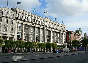
Clerys
Former department store and related shops in Dublin, Ireland
Distance: Approx. 82 meters
Latitude and longitude: 53.34917,-6.25966
Clerys was a long-established department store on O'Connell Street in Dublin, Ireland, a focal point of the street. The business dates from 1853, however the current building dates from 1922, the original having been completely destroyed in the 1916 Easter Rising. Clerys completed a five-year restoration programme in 2004 at a cost of €24 million but went into receivership in 2012, and was sold.
Capitol Theatre, Dublin
Irish venue
Distance: Approx. 110 meters
Latitude and longitude: 53.34889,-6.26094
The Capitol Theatre was located in Prince's Street, just off O'Connell Street, Dublin, and began life on 10 August 1920 as the La Scala Theatre and Opera House. Designed by architect T. F. McNamara it had two balconies in the 1,900-seat auditorium with 32 private boxes. Despite its name, the La Scala was a cinema.
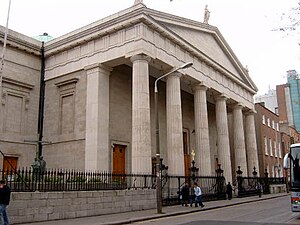
Roman Catholic Archdiocese of Dublin
Lead diocese of the Metropolitan Province of Dublin, Ireland
Distance: Approx. 138 meters
Latitude and longitude: 53.35083333,-6.25916667
The Archdiocese of Dublin (Irish: Ard-Deoise Bhaile Átha Cliath) is a Latin Church ecclesiastical territory or archdiocese of the Catholic Church located in the eastern part of Ireland. Its archepiscopal see includes the republic's capital city – Dublin. The cathedral church of the archdiocese is St Mary's Pro-Cathedral.

Nelson's Pillar
Former column and statue in Dublin, Ireland
Distance: Approx. 4 meters
Latitude and longitude: 53.34980556,-6.26025
Nelson's Pillar (also known as the Nelson Pillar or simply the Pillar) was a large granite column capped by a statue of Horatio Nelson, built in the centre of what was then Sackville Street (later renamed O'Connell Street) in Dublin, Ireland. Completed in 1809 when Ireland was part of the United Kingdom, it survived until March 1966, when it was severely damaged by explosives planted by Irish republicans. Its remnants were later destroyed by the Irish Army.

North Earl Street
Short street in central Dublin, Ireland
Distance: Approx. 77 meters
Latitude and longitude: 53.349999,-6.259197
North Earl Street (Irish: Sráid an Iarla Thuaidh) is a short stretch of city-centre street located on Dublin's Northside and formerly a major shopping area. It runs from Marlborough Street in the west to O'Connell Street beside the Spire. The street was first developed in the late 18th century.

O'Connell - GPO Luas stop
Tram stop in Dublin, Ireland
Distance: Approx. 109 meters
Latitude and longitude: 53.34884462,-6.259927
O'Connell - GPO (Irish: Ó Conaill - AOP) is a stop on the Luas light-rail tram system in Dublin, Ireland. It opened in 2017 as a stop on Luas Cross City, an extension of the Green Line through the city centre from St. Stephen's Green to Broombridge.

Cathedral Street, Dublin
Street in Dublin, Ireland
Distance: Approx. 103 meters
Latitude and longitude: 53.3505376,-6.25936366
Cathedral Street is a street in central Dublin, Ireland, formerly known as Elephant Lane and Tyrone Place.

Imperial Hotel, Dublin
Former hotel in Dublin, Ireland
Distance: Approx. 91 meters
Latitude and longitude: 53.34912,-6.25956
The Imperial Hotel was a hotel in Dublin's principal thoroughfare, Sackville Street, until it was destroyed during the Easter Rising of 1916. The building comprised Clerys department store on the lower floors and the Imperial Hotel on upper floors situated opposite the General Post Office and Nelson's Pillar.
Weather in this IP's area
scattered clouds
15 Celsius
15 Celsius
12 Celsius
16 Celsius
1008 hPa
94 %
1008 hPa
1006 hPa
6000 meters
3.6 m/s
270 degree
40 %
06:47:17
19:58:19