144.178.251.101 - IP Lookup: Free IP Address Lookup, Postal Code Lookup, IP Location Lookup, IP ASN, Public IP
Country:
Region:
City:
Location:
Time Zone:
Postal Code:
ISP:
ASN:
language:
User-Agent:
Proxy IP:
Blacklist:
IP information under different IP Channel
ip-api
Country
Region
City
ASN
Time Zone
ISP
Blacklist
Proxy
Latitude
Longitude
Postal
Route
db-ip
Country
Region
City
ASN
Time Zone
ISP
Blacklist
Proxy
Latitude
Longitude
Postal
Route
IPinfo
Country
Region
City
ASN
Time Zone
ISP
Blacklist
Proxy
Latitude
Longitude
Postal
Route
IP2Location
144.178.251.101Country
Region
antwerpen
City
antwerpen
Time Zone
Europe/Brussels
ISP
Language
User-Agent
Latitude
Longitude
Postal
ipdata
Country
Region
City
ASN
Time Zone
ISP
Blacklist
Proxy
Latitude
Longitude
Postal
Route
Popular places and events near this IP address

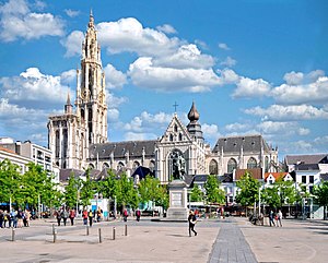
Cathedral of Our Lady (Antwerp)
Roman Catholic cathedral in Antwerp, Belgium
Distance: Approx. 218 meters
Latitude and longitude: 51.22055556,4.40055556
The Cathedral of Our Lady (Dutch: Onze-Lieve-Vrouwekathedraal) is a Roman Catholic cathedral in Antwerp, Belgium. Today's seat of the Diocese of Antwerp started in 1352 and, although the first stage of construction was ended in 1521, has never been 'completed'. It was constructed in the Gothic style by architects Jan and Pieter Appelmans.

Boerentoren
Historic high-rise building in Antwerp, Belgium
Distance: Approx. 151 meters
Latitude and longitude: 51.218611,4.404167
The Boerentoren (English: "Farmers' Tower"; officially the KBC Tower, originally the Torengebouw van Antwerpen) is a historic high-rise building in Antwerp, Belgium. Constructed between 1929 and 1932 and originally 87.5 m (287 ft) high, it remained the tallest building and the second-tallest structure in the city (after the Gothic Cathedral of Our Lady) until 2019, when the Antwerp Tower surpassed it with a height of 100.7 m (330 ft). At the time of construction, it was the second tallest building in Europe by roof height (after the Telefónica Building in Madrid).

Roman Catholic Diocese of Antwerp
Catholic ecclesiastical territory in Belgium
Distance: Approx. 197 meters
Latitude and longitude: 51.218214,4.402657
The Diocese of Antwerp (Latin: Dioecesis Antverpiensis) is a Latin Church ecclesiastical territory or diocese of the Catholic Church in Belgium. The diocese was restored in 1961. It is a suffragan in the ecclesiastical province of the metropolitan Archdiocese of Mechelen-Brussels.

Violieren
Distance: Approx. 173 meters
Latitude and longitude: 51.2203,4.4059
The Violieren (wallflower or gillyflower) was a chamber of rhetoric that dates back to the 15th century in Antwerp, when it was a social drama society with close links to the Guild of Saint Luke. It was one of three drama guilds in the city, the other two being the Goudbloem and the Olyftack. In 1660 the Violieren merged with former rival Olyftack, and in 1762 the society was dissolved altogether.

St. Charles Borromeo Church, Antwerp
Church in Antwerp, Belgium
Distance: Approx. 145 meters
Latitude and longitude: 51.22105556,4.40447222
St. Charles Borromeo Church (Dutch: Sint-Carolus Borromeuskerk) is a Roman Catholic church in central Antwerp, Belgium, located on the Hendrik Conscienceplein. It was built in 1615–1621 as the Jesuit church of Antwerp, which was closed in 1773.

Hendrik Conscience Heritage Library
Distance: Approx. 104 meters
Latitude and longitude: 51.2208,4.4039
The Hendrik Conscience Heritage Library (Dutch: Erfgoedbibliotheek Hendrik Conscience) is the repository library of the city of Antwerp. It is named after the Flemish writer Hendrik Conscience, whose statue adorns the library. The library conserves books and magazines to keep them available permanently.

De Olijftak
Distance: Approx. 173 meters
Latitude and longitude: 51.2203,4.4059
De Olijftak (The Olive Branch), or in full Gulde van den Heyligen Geest die men noempt den Olijftak (Confraternity of the Holy Spirit called the Olive Branch), was a chamber of rhetoric that dates back to the early 16th century in Antwerp, when it was a social drama society drawing its membership primarily from merchants and tradesmen. In 1660 it merged with its former rival the Violieren (which was more closely associated with artists and intellectuals), and in 1762 the society was dissolved altogether.
Goudbloem
Distance: Approx. 173 meters
Latitude and longitude: 51.2203,4.4059
The Goudbloem (marigold) was a chamber of rhetoric, a society to promote poetry and drama, that dated back to the 15th century in Antwerp. It was one of three drama guilds in the city, the other two being the Violieren and the Olyftack. It ceased to exist around 1654.

Snijders&Rockox House
Museum in Antwerp, Belgium
Distance: Approx. 270 meters
Latitude and longitude: 51.2217,4.4061
The Snijders&Rockox House (Dutch: Snijders&Rockoxhuis) is a museum in Antwerp, Belgium. It is located in two neighbouring townhouses formerly owned by the artist Frans Snyders (1579–1657) and the mayor Nicolaas Rockox (1560–1640). It is owned by KBC Bank and showcases a collection of 16th and 17th century Flemish art.

Groenplaats (Antwerp premetro station)
Premetro station in Antwerp, Belgium
Distance: Approx. 192 meters
Latitude and longitude: 51.21861111,4.40166667
Groenplaats premetro station is an Antwerp premetro station. Located underneath the Groenplaats, it is served by lines 3, 5, 9 and 15. Groenplaats premetro station was opened on 25 March 1975 and is one of the oldest premetro stations in Antwerp.

Bourse at Antwerp
Financial exchange
Distance: Approx. 194 meters
Latitude and longitude: 51.219306,4.406111
The bourse at Antwerp is a building in Antwerp, Belgium, which was first opened in 1531 as the world's first purpose-built commodity exchange. The Royal Exchange in London was modelled on the Antwerp bourse. The bourse has been described as "the mother of all stock exchanges".

Groenplaats
Square in Antwerp, Belgium
Distance: Approx. 152 meters
Latitude and longitude: 51.21916667,4.40166667
The Groenplaats (Green Square) is a large square in the center of the Belgian city of Antwerp, situated south of the Antwerp cathedral. There are various trees with benches on the square, which is a 'resting place'. A statue of Rubens, designed in 1840 and erected in 1843 by Willem Geefs, is in the center of the square.
Weather in this IP's area
light intensity drizzle
5 Celsius
2 Celsius
4 Celsius
5 Celsius
1001 hPa
96 %
1001 hPa
1000 hPa
8000 meters
3.09 m/s
310 degree
100 %