Country:
Region:
City:
Latitude and Longitude:
Time Zone:
Postal Code:
IP information under different IP Channel
ip-api
Country
Region
City
ASN
Time Zone
ISP
Blacklist
Proxy
Latitude
Longitude
Postal
Route
Luminati
Country
Region
tx
City
dallas
ASN
Time Zone
America/Chicago
ISP
DCCCD
Latitude
Longitude
Postal
IPinfo
Country
Region
City
ASN
Time Zone
ISP
Blacklist
Proxy
Latitude
Longitude
Postal
Route
db-ip
Country
Region
City
ASN
Time Zone
ISP
Blacklist
Proxy
Latitude
Longitude
Postal
Route
ipdata
Country
Region
City
ASN
Time Zone
ISP
Blacklist
Proxy
Latitude
Longitude
Postal
Route
Popular places and events near this IP address

Cockrell Hill, Texas
City in Texas, United States
Distance: Approx. 1709 meters
Latitude and longitude: 32.73805556,-96.88861111
Cockrell Hill is a city in Dallas County, Texas, United States. The population was 4,193 at the 2010 census, and 3,815 in 2020. It is completely surrounded by the city of Dallas.
Westmoreland station (DART)
DART light rail station in Dallas, Texas
Distance: Approx. 3789 meters
Latitude and longitude: 32.71972222,-96.87180556
Westmoreland Road station is a DART light rail station in Dallas, Texas. It is located in the Oak Cliff neighborhood at Illinois Avenue and Westmoreland Road. It opened on June 14, 1996 and is the southwest terminus of the Red Line, serving the nearby residential and commercial areas and featuring bus service to Southwest Center Mall.
Dallas College Mountain View
Distance: Approx. 1425 meters
Latitude and longitude: 32.724308,-96.903474
Dallas College Mountain View Campus (often stylized as Mountain View or MVC) is a public community college in Dallas, Texas. It is part of Dallas College. The campus opened its doors in 1970 and features an enrollment of about 11,500 credit students and another 9,000 continuing education students.
Moisés E. Molina High School
Public, secondary school in Dallas, Texas
Distance: Approx. 1570 meters
Latitude and longitude: 32.723088,-96.910709
Moisés E. Molina High School is a public secondary school in the Oak Cliff area of Dallas, Texas (USA). Molina High School is part of the Dallas Independent School District and serves students from parts of southwestern Dallas and parts of Cockrell Hill. In 2015, the school was rated "Met Standard" by the Texas Education Agency.
Dallas–Fort Worth National Cemetery
Veterans cemetery in Dallas County, Texas
Distance: Approx. 3749 meters
Latitude and longitude: 32.71666667,-96.93888889
Dallas–Fort Worth National Cemetery is a United States national cemetery located in the city of Dallas, Dallas County, Texas (United States). Administered by the United States Department of Veterans Affairs, it encompasses 638 acres (258 ha), and as of 2021, had over 73,000 interments.
Bernal/Singleton Transfer Location
Bus station in West Dallas, Texas
Distance: Approx. 4722 meters
Latitude and longitude: 32.7792,-96.9053
Bernal/Singleton Transfer Location is a bus-only public transit station in Dallas, Texas. The station is located in West Dallas at the intersection of Bernal Drive and Singleton Boulevard. It is operated by Dallas Area Rapid Transit and serves two bus routes, as well as a microtransit service for the West Dallas area.
Kessler Plaza, Dallas
Distance: Approx. 4440 meters
Latitude and longitude: 32.7485,-96.86147
Kessler Plaza is a neighborhood located in the Kessler area of Dallas, Texas, United States. It is the southernmost of the Kessler neighborhoods. Development of Kessler Plaza began in the 1930s and continued into the 1950s.
Patriot Field
Baseball field in Dallas, Texas, US
Distance: Approx. 4562 meters
Latitude and longitude: 32.71166667,-96.94527778
Patriot Field is a baseball field located in Dallas, Texas, United States, and was home to the Dallas Baptist Patriots baseball team from 1983 to 2012. The venue was finished in the summer of 1983 and has had many improvements done through the years since its inception. The field has also made a cameo appearance in Chuck Norris' The President's Man, a made-for-TV movie, for CBS in 2001.
The Potter's House (Dallas)
Church in Texas, United States
Distance: Approx. 4423 meters
Latitude and longitude: 32.708259,-96.939653
The Potter's House is a megachurch in Dallas, Texas, United States, founded by T. D. Jakes. Outreach magazine ranked it the 10th largest in the US as of 2008 based on a weekly attendance of 17,000 and a capacity of about 8,000.
Cockrell Hill Transfer Location
Bus station in Cockrell Hill, Texas
Distance: Approx. 1365 meters
Latitude and longitude: 32.73694444,-96.89222222
Cockrell Hill Transfer Location is a bus-only public transit station in Cockrell Hill, Texas. The station is operated by Dallas Area Rapid Transit and is located along Jefferson Boulevard at its intersection with Cockrell Hill Road. The station features a small indoor, air-conditioned waiting area, restrooms, and an information desk, all of which are available during weekday peak hours.

Horner Ballpark
Baseball field in Dallas, Texas
Distance: Approx. 4602 meters
Latitude and longitude: 32.71138889,-96.94555556
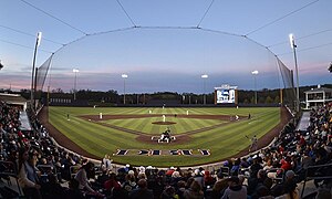
Horner Ballpark is a baseball field in Dallas, Texas. It is the home park of the Dallas Baptist Patriots baseball team of the NCAA Division I Conference USA. It opened on February 15, 2013, and has been highly acclaimed by national media, including D1Baseball.com. The stadium is named for Joan and Andy Horner, who made the lead donation for the park.
Trini Garza Early College High School
Senior high school in Dallas, Texas
Distance: Approx. 1144 meters
Latitude and longitude: 32.72694444,-96.90333333
Trinidad "Trini" Garza Early College High School is an early college senior high school in the grounds of Mountain View College in Dallas, Texas. It is a part of the Dallas Independent School District. It was one of the district's first early college high schools.
Weather in this IP's area
mist
21 Celsius
22 Celsius
20 Celsius
22 Celsius
1011 hPa
96 %
1011 hPa
992 hPa
4023 meters
5.66 m/s
130 degree
100 %
06:51:56
17:30:58

