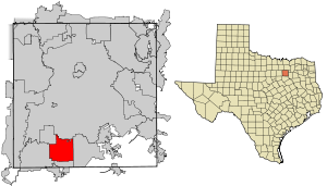
Country:
Region:
City:
Latitude and Longitude:
Time Zone:
Postal Code:
IP information under different IP Channel
ip-api
Country
Region
City
ASN
Time Zone
ISP
Blacklist
Proxy
Latitude
Longitude
Postal
Route
Luminati
Country
Region
tx
City
desoto
ASN
Time Zone
America/Chicago
ISP
DCCCD
Latitude
Longitude
Postal
IPinfo
Country
Region
City
ASN
Time Zone
ISP
Blacklist
Proxy
Latitude
Longitude
Postal
Route
db-ip
Country
Region
City
ASN
Time Zone
ISP
Blacklist
Proxy
Latitude
Longitude
Postal
Route
ipdata
Country
Region
City
ASN
Time Zone
ISP
Blacklist
Proxy
Latitude
Longitude
Postal
Route
Popular places and events near this IP address

DeSoto, Texas
City in the United States
Distance: Approx. 1210 meters
Latitude and longitude: 32.59916667,-96.85888889
DeSoto is a city in Dallas County, Texas, United States. DeSoto is a suburb of Dallas and is part of the Best Southwest area, which includes DeSoto, Cedar Hill, Duncanville, and Lancaster.

Duncanville, Texas
City in Texas, United States
Distance: Approx. 4839 meters
Latitude and longitude: 32.63472222,-96.90666667
Duncanville is a city in southwestern Dallas County, Texas, United States. Duncanville's population was 40,706 at the 2020 census. The city is part of the Best Southwest area, which includes Duncanville, Cedar Hill, DeSoto, and Lancaster.

DeSoto Independent School District
School district in Dallas County, Texas, United States
Distance: Approx. 2443 meters
Latitude and longitude: 32.58662,-96.8675
DeSoto Independent School District is a school district based in DeSoto, Texas (USA). The district covers most of DeSoto, the Dallas County portion of Glenn Heights, and a section of Ovilla in Dallas County, as well as a small portion of Cedar Hill. In 2009, the school district was rated "academically acceptable" by the Texas Education Agency.
DeSoto High School Freshman Campus
Public school in DeSoto, Texas, U.S.
Distance: Approx. 3166 meters
Latitude and longitude: 32.580396,-96.870704
DeSoto High School Freshman Campus is a public school in DeSoto, Texas, United States. It is part of the DeSoto Independent School District. Located at 620 South Westmoreland Road, the school serves the district's ninth graders.
DeSoto High School (Texas)
Public high school in the United States
Distance: Approx. 3086 meters
Latitude and longitude: 32.580999,-96.869616
DeSoto High School is a four-year comprehensive public high school in DeSoto, Texas, United States. It is part of the DeSoto Independent School District and is classified as a 6A school by the UIL. In 2015, the school was rated "Met Standard" by the Texas Education Agency. The district, and therefore the school, serves most of DeSoto and the Dallas County portion of Glenn Heights, and a portion of Ovilla in Dallas County, as well as a small portion of Cedar Hill.
John Kincaide Stadium
Multi-use stadium in Dallas, Texas
Distance: Approx. 3970 meters
Latitude and longitude: 32.6385,-96.8426
John Kincaide Stadium is a 15,000-seat multi-use stadium in Dallas, Texas owned and operated by the Dallas Independent School District. It opened in 2005. In 2023, a track at this stadium was renamed the Sha'Carri Richardson Track.
David W. Carter High School
Public, secondary school in Dallas, Texas, United States
Distance: Approx. 4718 meters
Latitude and longitude: 32.6483,-96.8482
David Wendel Carter High School (commonly referred to as Dallas Carter) is a public high school located in the Oak Cliff area of Dallas, Texas, United States. The school is a part of the Dallas Independent School District and is classified as a 4A school by the UIL. In 2015, the school was rated "Met Standard" by the Texas Education Agency.
Trinity Christian School (Cedar Hill, Texas)
Private Christian school in Cedar Hill, Texas, United States
Distance: Approx. 4468 meters
Latitude and longitude: 32.60492,-96.912952
Trinity Christian School is a private Christian school founded in 1981. The campus is located at Trinity Church in Cedar Hill, Texas and is affiliated with Trinity Ministries. Trinity School educates students from pre-school and K5 – 12th grade students, and is considered a College Preparatory School.
Inspiring Body of Christ Church
Church in Texas, United States
Distance: Approx. 5219 meters
Latitude and longitude: 32.651,-96.889
The Inspiring Body of Christ Church (IBOC) is a non-denominational megachurch in Dallas, Texas in the United States. A survey by Outreach Magazine in 2008 ranked the church 87th in the US based on weekly attendance of 7,500 and has since grown to 15,000 members.

Life School
School in Red Oak, Texas, United States
Distance: Approx. 5421 meters
Latitude and longitude: 32.57705,-96.821369
Life School is a charter school operator headquartered in Red Oak, Texas. Life School was chartered in the state of Texas in 1998 and has campuses in Dallas-Fort Worth, Cedar Hill, Carrollton, Lancaster, Oak Cliff, Red Oak, Waxahachie, and West Dallas. It operates with a private school atmosphere and adheres to public school education requirements mandated by the state.
Western Lake, Texas
Census-designated place in Texas, United States
Distance: Approx. 4848 meters
Latitude and longitude: 32.62138889,-96.81611111
Western Lake is a census-designated place in Parker County, Texas, United States. This was a new CDP for the 2010 census with a population of 1,525.
DeSoto Heliport
Municipal heliport in DeSoto, Texas, United States
Distance: Approx. 2751 meters
Latitude and longitude: 32.63166667,-96.85527778
DeSoto Heliport (FAA LID: 73T) is a city-owned public heliport in DeSoto, Dallas County, Texas, United States, located 3 nautical miles (5.6 km) north of the central business district. The heliport has no IATA or ICAO designation. The facility opened in August 2014 under joint ownership by the City of DeSoto, the Texas Department of Transportation, and the DeSoto Economic Development Corporation.
Weather in this IP's area
clear sky
22 Celsius
20 Celsius
20 Celsius
23 Celsius
1018 hPa
27 %
1018 hPa
997 hPa
10000 meters
2.06 m/s
50 degree
06:57:01
17:27:11