144.129.53.165 - IP Lookup: Free IP Address Lookup, Postal Code Lookup, IP Location Lookup, IP ASN, Public IP
Country:
Region:
City:
Location:
Time Zone:
Postal Code:
ISP:
ASN:
language:
User-Agent:
Proxy IP:
Blacklist:
IP information under different IP Channel
ip-api
Country
Region
City
ASN
Time Zone
ISP
Blacklist
Proxy
Latitude
Longitude
Postal
Route
db-ip
Country
Region
City
ASN
Time Zone
ISP
Blacklist
Proxy
Latitude
Longitude
Postal
Route
IPinfo
Country
Region
City
ASN
Time Zone
ISP
Blacklist
Proxy
Latitude
Longitude
Postal
Route
IP2Location
144.129.53.165Country
Region
california
City
bakersfield
Time Zone
America/Los_Angeles
ISP
Language
User-Agent
Latitude
Longitude
Postal
ipdata
Country
Region
City
ASN
Time Zone
ISP
Blacklist
Proxy
Latitude
Longitude
Postal
Route
Popular places and events near this IP address
Garces Memorial High School
Private, coeducational school in Bakersfield, California, United States
Distance: Approx. 1991 meters
Latitude and longitude: 35.4,-118.99944444
Garces Memorial High School, commonly shortened to Garces High School, is a Catholic high school in Bakersfield, California. The school offers college prep, honors, and Advanced Placement (AP) courses in many subjects. As a Catholic institution, the high school requires theology classes for all four years.

Memorial Stadium (Bakersfield)
Distance: Approx. 2581 meters
Latitude and longitude: 35.40722222,-118.96944444
Memorial Stadium is a double-decked concrete and steel stadium in the western United States, located in northeast Bakersfield, California, near the scenic Panorama Bluffs, which overlook the prolific Kern River Oil Field. In July 2019, an artificial playing surface was installed replacing the worn out and troublesome Bermuda grass field which was susceptible to fungus growth. An all-weather track was also installed In 2020 a new scoreboard and sound system were installed along with new L.E.D. lights placed upon the original light standards.

Elijah Stephens
Historic site in in Kern County, California
Distance: Approx. 2305 meters
Latitude and longitude: 35.39737222,-119.00619444
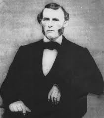
Elijah Stephens also spelled Elisha Stevens was a blacksmith and trapper who was born in South Carolina. In 1844, he left Council Bluffs, Iowa as the captain of the Stephens-Townsend-Murphy Party, the first wagon train to cross the Sierra Nevada mountains into Alta California. He then moved to Cupertino, California, in 1848.
East Bakersfield, California
Place in California, United States
Distance: Approx. 987 meters
Latitude and longitude: 35.38318611,-118.97436944
East Bakersfield is an unincorporated community and census-designated place (CDP) in Kern County, California.
Mill Creek (Bakersfield)
Distance: Approx. 2461 meters
Latitude and longitude: 35.37666667,-119.00777778
Mill Creek is a linear park located in Bakersfield, California. It runs along the Kern Island Canal between Golden State Avenue and California Avenue in downtown, although there is a gap between 19th Street and the BNSF railroad yard. The center of the park is Central Park, the only park in downtown.
Jefferson Park (Bakersfield)
Distance: Approx. 261 meters
Latitude and longitude: 35.38888889,-118.98611111
Jefferson Park is a public park located in Bakersfield, California.

Bakersfield station (Southern Pacific Railroad)
Distance: Approx. 1360 meters
Latitude and longitude: 35.37694444,-118.99194444
Bakersfield station is a former Southern Pacific Railroad station and hotel in Bakersfield, California. The station opened June 27, 1889, in the town of Sumner (which was later annexed by Bakersfield). The station was a mixture of Richardsonian Romanesque, Spanish Colonial Revival, and Moderne styles.

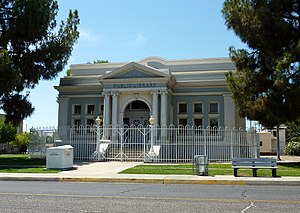
Kern Branch, Beale Memorial Library
United States historic place
Distance: Approx. 682 meters
Latitude and longitude: 35.38361111,-118.99
The Baker Street Library, is a library located at 1400 Baker St. in Bakersfield, California. The library was constructed from 1913 to 1915 and replaced Bakersfield's original library building.
Kern Medical Center
Hospital in California, United States
Distance: Approx. 1401 meters
Latitude and longitude: 35.38247,-118.96975
Kern Medical Formerly Kern Medical Center, is a 222-bed teaching hospital located in Bakersfield, California in central California's San Joaquin Valley. The hospital was founded in 1867.

Alexis Godey
Scout and Mountain Man
Distance: Approx. 2514 meters
Latitude and longitude: 35.37631944,-119.00820277
Alexander "Alexis" Godey, also called Alec Godey and Alejandro Godey, was a trapper, scout, and mountain man. He was an associate of Jim Bridger and was lead scout for John C. Frémont.
Hillcrest, Kern County, California
Census-designated place in California
Distance: Approx. 2548 meters
Latitude and longitude: 35.37897,-118.957853
Hillcrest is an unincorporated community and census-designated place (CDP) in Kern County, California. The population was 10,528 at the 2020 census.
La Cresta, Kern County, California
CDP in Kern County, California
Distance: Approx. 1175 meters
Latitude and longitude: 35.39692222,-118.98931111
La Cresta is a census-designated place (CDP) in Kern County, California. The CDP is within Bakersfield's census county division, and is surrounded by the city of Bakersfield on most sides, but borders East Bakersfield to the southeast. Its population was 8,787 at the 2020 census.
Weather in this IP's area
clear sky
3 Celsius
1 Celsius
2 Celsius
3 Celsius
1033 hPa
83 %
1033 hPa
1013 hPa
10000 meters
1.68 m/s
1.67 m/s
107 degree
9 %
