143.55.23.181 - IP Lookup: Free IP Address Lookup, Postal Code Lookup, IP Location Lookup, IP ASN, Public IP
Country:
 USA
USARegion:
City:
Location:
Time Zone:
Postal Code:
ISP:
ASN:
language:
User-Agent:
Proxy IP:
Blacklist:
IP information under different IP Channel
ip-api
Country
Region
City
ASN
Time Zone
ISP
Blacklist
Proxy
Latitude
Longitude
Postal
Route
db-ip
Country
Region
City
ASN
Time Zone
ISP
Blacklist
Proxy
Latitude
Longitude
Postal
Route
IPinfo
Country
Region
City
ASN
Time Zone
ISP
Blacklist
Proxy
Latitude
Longitude
Postal
Route
IP2Location
143.55.23.181Country
usRegion
kentucky
City
harold
Time Zone
America/New_York
ISP
Language
User-Agent
Latitude
Longitude
Postal
ipdata
Country
Region
City
ASN
Time Zone
ISP
Blacklist
Proxy
Latitude
Longitude
Postal
Route
Popular places and events near this IP address

Coal Run Village, Kentucky
City in Kentucky, United States
Distance: Approx. 7346 meters
Latitude and longitude: 37.53722222,-82.55777778
Coal Run Village (sometimes simply Coal Run) is a home rule-class city in Pike County, Kentucky, in the United States. Bordered to the north, south, and east by Pikeville, the population was 1,706 at the 2010 census. It was the fastest-growing city in Kentucky from 2007 to 2008, with a population increase of 17.3%.
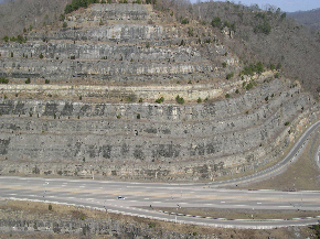
Pikeville Cut-Through
Rock cut in Pikeville, Kentucky, US
Distance: Approx. 7287 meters
Latitude and longitude: 37.47527,-82.53891
The Pikeville Cut-Through is a rock cut in Pikeville, Kentucky, United States, created by the U.S. Army Corps of Engineers, through which passes a four-lane divided highway (Corridor B, numbered as U.S. Route 23 (US 23), US 119, US 460, and KY 80), a railroad line (CSX' Big Sandy Subdivision), and the Levisa Fork of the Big Sandy River. It is one of the largest civil engineering projects in the Western Hemisphere. Nearly 18,000,000 cubic yards (14,000,000 m3) of soil and rock were moved, making the Pikeville Cut-Through second only to the Panama Canal (240,000,000 cubic yards (180,000,000 m3)) when ranking the hemisphere's largest earth-moving projects.

Pikeville High School
Public school in Pikeville, Kentucky, United States
Distance: Approx. 6671 meters
Latitude and longitude: 37.48798,-82.54326
Pikeville High School (PHS) is located in Pikeville, Kentucky, United States. It enrolls approximately 560 students in grades 7–12. It is part of the Pikeville Independent Schools.

Betsy Layne, Kentucky
Census-designated place in Kentucky, United States
Distance: Approx. 6930 meters
Latitude and longitude: 37.55416667,-82.62611111
Betsy Layne is a census-designated place (CDP) and coal town in Floyd County, Kentucky, United States. It was established in 1875 along the Levisa Fork. The post office opened on May 1, 1908, with Clayton S. Hitchins as postmaster.
Blue Moon, Kentucky
Unincorporated community in Kentucky, United States
Distance: Approx. 7197 meters
Latitude and longitude: 37.5075,-82.69777778
Blue Moon is an unincorporated community located in Floyd County, Kentucky, United States. A post office was established in 1936 by Alex L. Meade, a local schoolteacher. The name was selected by Meade's daughter Alice, who had received a bottle of Blue Moon perfume as a Christmas present.
Harold, Kentucky
Unincorporated community in Kentucky, United States
Distance: Approx. 5118 meters
Latitude and longitude: 37.53666667,-82.63333333
Harold is an unincorporated community located in Floyd County, Kentucky, United States. A post office was established in the community in 1905, and named for local merchant Harold Hatcher of the Hatcher family of early area settlers. Professional baseball player Dixie Howell was born in Harold.
Grethel, Kentucky
Unincorporated community in Kentucky, United States
Distance: Approx. 2580 meters
Latitude and longitude: 37.49111111,-82.64777778
Grethel is an unincorporated community located in Floyd County, Kentucky, United States. A post office was established in the community in 1921, and named for the first postmaster's daughter.
Mossy Bottom, Kentucky
Unincorporated community in Kentucky, United States
Distance: Approx. 5446 meters
Latitude and longitude: 37.53,-82.57944444
Mossy Bottom is part of Coal Run Village in Pike County, Kentucky, United States.
Hamlack, Kentucky
Unincorporated community in Kentucky, United States
Distance: Approx. 4640 meters
Latitude and longitude: 37.52944444,-82.595
Hamlack is an unincorporated community and coal town in Pike County, Kentucky, United States.
Big Shoal, Kentucky
Unincorporated community in Kentucky, United States
Distance: Approx. 5338 meters
Latitude and longitude: 37.51305556,-82.56416667
Big Shoal is an unincorporated community and coal town in Pike County, Kentucky, United States. Its post office has been closed.
Little Dixie, Kentucky
Unincorporated community in Kentucky, United States
Distance: Approx. 6251 meters
Latitude and longitude: 37.46138889,-82.55944444
Little Dixie (also Little Dixi) is an unincorporated community in Pike County, Kentucky, United States.
Broad Bottom, Kentucky
Unincorporated community in Kentucky, United States
Distance: Approx. 5188 meters
Latitude and longitude: 37.53416667,-82.59305556
Broad Bottom is an unincorporated community in Pike County, Kentucky, United States.
Weather in this IP's area
overcast clouds
1 Celsius
-3 Celsius
-0 Celsius
2 Celsius
1031 hPa
77 %
1031 hPa
986 hPa
10000 meters
3.09 m/s
7.72 m/s
260 degree
100 %