Country:
Region:
City:
Latitude and Longitude:
Time Zone:
Postal Code:
IP information under different IP Channel
ip-api
Country
Region
City
ASN
Time Zone
ISP
Blacklist
Proxy
Latitude
Longitude
Postal
Route
Luminati
Country
Region
rs
City
gramado
ASN
Time Zone
America/Sao_Paulo
ISP
RBT Internet
Latitude
Longitude
Postal
IPinfo
Country
Region
City
ASN
Time Zone
ISP
Blacklist
Proxy
Latitude
Longitude
Postal
Route
db-ip
Country
Region
City
ASN
Time Zone
ISP
Blacklist
Proxy
Latitude
Longitude
Postal
Route
ipdata
Country
Region
City
ASN
Time Zone
ISP
Blacklist
Proxy
Latitude
Longitude
Postal
Route
Popular places and events near this IP address

Gramado
Town in Rio Grande do Sul, Brazil
Distance: Approx. 5054 meters
Latitude and longitude: -29.4,-50.86666667
Gramado is a municipality in the state of Rio Grande do Sul, Brazil. It is located in the Serra Gaúcha region. The city was originally settled by Azorean descendants and later received a contingent of German and Italian immigrants.
Canela, Rio Grande do Sul
Municipality in Rio Grande do Sul, Brazil
Distance: Approx. 7776 meters
Latitude and longitude: -29.36166667,-50.81555556
Canela (Portuguese pronunciation: [kɐˈnɛlɐ]), meaning Cinnamon in Portuguese, is a town located in the Serra Gaúcha of Rio Grande do Sul, Brazil. Both Canela and neighboring Gramado are important tourist locations and they both draw many visitors each year. Ecotourism is very popular in the area and there are many opportunities for hiking, rock climbing, horseback riding and river rafting.
Church of Our Lady of Lourdes (Canela)
Building in Rio Grande do Sul, Brazil
Distance: Approx. 8397 meters
Latitude and longitude: -29.36388889,-50.80916667
The Church of Our Lady of Lourdes (Portuguese: Igreja Matriz de Nossa Senhora de Lourdes), is a Catholic church located in the Brazilian city of Canela, Rio Grande do Sul. It is erroneously known as the Cathedral of Stone (Portuguese: Catedral de Pedra), although the church is not actually a cathedral. It is considered one of the major tourist attractions of the Serra Gaúcha.

Caracol Falls
Waterfall in Canela, Rio Grande do Sul, Brazil.
Distance: Approx. 6959 meters
Latitude and longitude: -29.3112,-50.8544
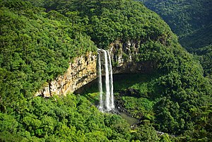
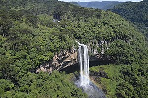
Caracol Falls or Cascata do Caracol, is a 426-foot (130 meters) waterfall about 4.35 miles (7.00 km) from Canela, Brazil in Caracol State Park (Parque Estadual do Caracol). It is formed by the Caracol River and cuts out of basalt cliffs in the Serra Geral mountain range, falling into the Vale da Lageana. The falls are situated between the pinheiral (araucaria pine forest) zone of the Brazilian Highlands and the southern coastal Atlantic Forest.

Caracol State Park
Distance: Approx. 6964 meters
Latitude and longitude: -29.311111,-50.854444
The Caracol State Park (Portuguese: Parque Estadual do Caracol) is a small state park in the state of Rio Grande do Sul, Brazil. It contains the dramatic Caracol Falls, a major tourist attraction.

Caracol River (Rio Grande do Sul)
River in Rio Grande do Sul, Brazil
Distance: Approx. 8293 meters
Latitude and longitude: -29.287979,-50.889873
The Caracol River Portuguese: Arroio Caracol is a river in the state of Rio Grande do Sul, Brazil. It is a tributary of the Caí River. The Caracol River is known for the dramatic Caracol Falls, a major tourist attraction.
Canela Airport
Airport in Brazil
Distance: Approx. 6226 meters
Latitude and longitude: -29.37055556,-50.83222222
Canela Airport (IATA: CEL, ICAO: SSCN), is the airport serving Canela and Gramado, Brazil. It is operated by Infraero.
Weather in this IP's area
clear sky
19 Celsius
19 Celsius
19 Celsius
20 Celsius
1015 hPa
57 %
1015 hPa
921 hPa
10000 meters
1.29 m/s
3.09 m/s
12 degree
5 %
05:23:11
18:52:02
