143.202.112.71 - IP Lookup: Free IP Address Lookup, Postal Code Lookup, IP Location Lookup, IP ASN, Public IP
Country:
Region:
City:
Location:
Time Zone:
Postal Code:
IP information under different IP Channel
ip-api
Country
Region
City
ASN
Time Zone
ISP
Blacklist
Proxy
Latitude
Longitude
Postal
Route
Luminati
Country
ASN
Time Zone
America/Sao_Paulo
ISP
Hilton C. Bender Eireli
Latitude
Longitude
Postal
IPinfo
Country
Region
City
ASN
Time Zone
ISP
Blacklist
Proxy
Latitude
Longitude
Postal
Route
IP2Location
143.202.112.71Country
Region
rio grande do sul
City
santo angelo
Time Zone
America/Sao_Paulo
ISP
Language
User-Agent
Latitude
Longitude
Postal
db-ip
Country
Region
City
ASN
Time Zone
ISP
Blacklist
Proxy
Latitude
Longitude
Postal
Route
ipdata
Country
Region
City
ASN
Time Zone
ISP
Blacklist
Proxy
Latitude
Longitude
Postal
Route
Popular places and events near this IP address

Santo Ângelo
Municipality in the state of Rio Grande do Sul, Brazil
Distance: Approx. 2157 meters
Latitude and longitude: -28.28333333,-54.25
Santo Ângelo is a municipality located in northwestern Rio Grande do Sul state, Brazil. It has about 77,568 inhabitants (according to 2020 IBGE estimate) and the total area of the municipality is about 679 km2. It borders Giruá to the north, and Entre-Ijuís to the south—it's linked to Santo Ângelo by the state road RS 344.

Entre-Ijuís
Municipality in Rio Grande do Sul, Brazil
Distance: Approx. 6797 meters
Latitude and longitude: -28.36,-54.26777778
Entre-Ijuís is a municipality of the western part of the state of Rio Grande do Sul, Brazil. The population is 8,938 (according to IBGE 2010 census) in an area of 552.60 km2. It takes its name from the Ijuí Grand River, on which it is situated.

Microregion of Santo Ângelo
Micro-region in Rio Grande do Sul, Brazil
Distance: Approx. 24 meters
Latitude and longitude: -28.29888889,-54.26277778
The Santo Ângelo micro-region (Microrregião de Santo Ângelo) is a micro-region in the western part of the state of Rio Grande do Sul, Brazil. The area is 10,750.721 km2.

Santo Ângelo Airport
Airport
Distance: Approx. 9461 meters
Latitude and longitude: -28.28166667,-54.16833333
Sepé Tiaraju Regional Airport (IATA: GEL, ICAO: SBNM) is the airport serving Santo Ângelo, Brazil. It is named after Sepé Tiaraju (c. 1723 – 7 February 1756), a Guaraní warrior who led the Guaraní forces in the Guaraní War in Misiones Orientales. It is managed by contract by Infraero.

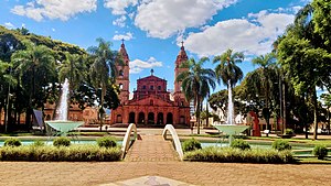
Guardian Angel Cathedral, Santo Ângelo
Church in Rio Grande do Sul, Brazil
Distance: Approx. 666 meters
Latitude and longitude: -28.305,-54.26166667
Guardian Angel Cathedral (Portuguese: Catedral Anjo da Guarda), also called Angelopolitan Cathedral (Portuguese: Catedral Angelopolitana), is a Roman Catholic cathedral located in Santo Ângelo in the state of Rio Grande do Sul in Brazil. It is the main tourist attraction of the city and the seat of the Diocese of Santo Ângelo. It began to be constructed by in 1929 and its style resembles the temple of St.
Weather in this IP's area
clear sky
20 Celsius
19 Celsius
20 Celsius
20 Celsius
1009 hPa
33 %
1009 hPa
977 hPa
10000 meters
1.96 m/s
3.38 m/s
111 degree