142.73.170.108 - IP Lookup: Free IP Address Lookup, Postal Code Lookup, IP Location Lookup, IP ASN, Public IP
Country:
Region:
City:
Location:
Time Zone:
Postal Code:
IP information under different IP Channel
ip-api
Country
Region
City
ASN
Time Zone
ISP
Blacklist
Proxy
Latitude
Longitude
Postal
Route
Luminati
Country
ASN
Time Zone
America/Toronto
ISP
BACOM
Latitude
Longitude
Postal
IPinfo
Country
Region
City
ASN
Time Zone
ISP
Blacklist
Proxy
Latitude
Longitude
Postal
Route
IP2Location
142.73.170.108Country
Region
ontario
City
brampton
Time Zone
America/Toronto
ISP
Language
User-Agent
Latitude
Longitude
Postal
db-ip
Country
Region
City
ASN
Time Zone
ISP
Blacklist
Proxy
Latitude
Longitude
Postal
Route
ipdata
Country
Region
City
ASN
Time Zone
ISP
Blacklist
Proxy
Latitude
Longitude
Postal
Route
Popular places and events near this IP address

Bramalea, Ontario
Suburban district in Peel, Ontario, Canada
Distance: Approx. 3207 meters
Latitude and longitude: 43.725,-79.7175
Bramalea (Bram-a-lee) is a large suburban district in the City of Brampton, Ontario, Canada. Bramalea was created as an innovative "new town", and developed as a separate community from the original Town of Brampton. Located in the former Chinguacousy Township, it was Canada's first satellite community developed by one of the country's largest real estate developers, Bramalea Consolidated Developments (later Bramalea Limited).
Holy Name of Mary Catholic Secondary School
High school in Brampton, Canada
Distance: Approx. 2239 meters
Latitude and longitude: 43.7338,-79.7164
Holy Name of Mary Catholic Secondary School is an all-girls regional high school in Brampton, Ontario, Canada founded by the Felician Sisters. Originally located in Mississauga, it relocated to Brampton in 2008. Holy Name of Mary Catholic Secondary School is the only single-sex school in the Dufferin-Peel Catholic District School Board.

Air Canada Flight 621
1970 plane crash in Brampton, Ontario, Canada
Distance: Approx. 3278 meters
Latitude and longitude: 43.7798,-79.6912
Air Canada Flight 621 was an Air Canada Douglas DC-8, registered as CF-TIW, that crashed on July 5, 1970, while attempting to land at Toronto International Airport. It was flying on a Montreal–Toronto–Los Angeles route. It crashed in Toronto Gore Township, now part of Brampton.

Chinguacousy Secondary School
High school in Brampton, Ontario, Canada
Distance: Approx. 2299 meters
Latitude and longitude: 43.7375,-79.727
Chinguacousy Secondary School founded in 1972, is a high school located in Brampton, Ontario, Canada. Since 2000, the school's enrolment has expanded with the development of the surrounding area. The school sports teams and athletic programs have won a number of OFSAA championships; wrestling (1991, 1992, 1993, 1995), curling (1996, 1998), and rugby (1982).

Toronto Ontario Temple
Latter-day Saints temple in Canada
Distance: Approx. 3201 meters
Latitude and longitude: 43.744338,-79.746059
The Toronto Ontario Temple is the 44th operating temple of the Church of Jesus Christ of Latter-day Saints (LDS Church). The intent to build the temple was announced to local leaders on the morning of April 7, 1984, and then referenced by Gordon B. Hinckley, second counselor in the First Presidency, during the general conference session which followed. It was the second temple built in Canada (after the Cardston Alberta Temple), becoming the first country in the world, outside the United States, to have two temples in its borders.

Professor's Lake
Artificial lake in Brampton, Ontario
Distance: Approx. 2227 meters
Latitude and longitude: 43.7475,-79.73472222
Professor's Lake is a 65-acre (26 ha) spring-fed artificial lake located in Brampton, Ontario, Canada. In 1918, the area where the lake currently exists was a sand and gravel mining site supplying aggregates for construction projects in the northwest area of the Greater Toronto Area. During its lifetime, the site produced approximately 20 million tonnes (40 million tons) of aggregate.

Brampton Civic Hospital
Hospital in Ontario, Canada
Distance: Approx. 2893 meters
Latitude and longitude: 43.7473,-79.7432
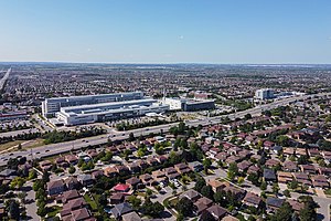
Brampton Civic Hospital is an acute care hospital in Brampton, Ontario and part of the William Osler Health System. It is a community teaching hospital for the Michael G. DeGroote School of Medicine of McMaster University.
Judith Nyman Secondary School
Secondary school in Brampton, Ontario, Canada
Distance: Approx. 2921 meters
Latitude and longitude: 43.73239,-79.73057
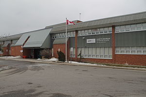
Judith Nyman Secondary School is a high school in Brampton, Ontario, Canada. It is one of two vocational schools operated by the Peel District School Board, the other being West Credit Secondary School in Mississauga. Upon graduation from Judith Nyman Secondary School, students receive an Ontario Secondary School Diploma or Certificate and may also qualify for a Skills Portfolio, which lists the trade-specific skills that the student has mastered through his or her in-school and co-op education courses.
Sandalwood Heights Secondary School
Public high school in Brampton, Ontario, Canada
Distance: Approx. 3224 meters
Latitude and longitude: 43.7659,-79.744
Sandalwood Heights Secondary School is a Canadian high school located in the city of Brampton, Ontario and is a part of the Peel District School Board. It opened in 2007. The Specialist High Skills Major program (SHSM) features student pathways in the business sector.
St. Thomas Aquinas Secondary School (Brampton)
Catholic school in Brampton, Canada
Distance: Approx. 1579 meters
Latitude and longitude: 43.73895,-79.71077
St. Thomas Aquinas or STA is a Catholic secondary school in Bramalea, Brampton, Ontario. It is under Dufferin-Peel Catholic District School Board.

Donald M. Gordon Chinguacousy Park
Park in Brampton, Ontario, Canada
Distance: Approx. 3248 meters
Latitude and longitude: 43.72472222,-79.71805556
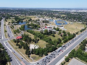
Donald M. Gordon Chinguacousy Park, colloquially known as Chinguacousy Park, is a large 40-hectare (100-acre) park in the Bramalea section of Brampton, Ontario, Canada. It is bounded by Queen Street East on the southeast, Bramalea Road on the northeast, and Central Park Drive on the north and west sides. Terry Fox Stadium (Brampton) in the north of the park, sometimes called Terry Fox Track and Field Stadium, has a track and field oval surrounding an artificial turf field with Canadian Football markings and stands for about 1000 spectators.
Goreway Power Station
Natural gas power station in Brampton, Ontario, Canada
Distance: Approx. 2386 meters
Latitude and longitude: 43.74611111,-79.68
Goreway Power Station is a natural gas power station in Brampton, Ontario. It is owned by Capital Power. Gas is supplied by underground pipelines from a nearby Enbridge facility.
Weather in this IP's area
overcast clouds
-5 Celsius
-12 Celsius
-6 Celsius
-5 Celsius
1022 hPa
87 %
1022 hPa
993 hPa
9656 meters
6.69 m/s
9.26 m/s
360 degree
100 %
