142.54.202.109 - IP Lookup: Free IP Address Lookup, Postal Code Lookup, IP Location Lookup, IP ASN, Public IP
Country:
Region:
City:
Location:
Time Zone:
Postal Code:
ISP:
ASN:
language:
User-Agent:
Proxy IP:
Blacklist:
IP information under different IP Channel
ip-api
Country
Region
City
ASN
Time Zone
ISP
Blacklist
Proxy
Latitude
Longitude
Postal
Route
db-ip
Country
Region
City
ASN
Time Zone
ISP
Blacklist
Proxy
Latitude
Longitude
Postal
Route
IPinfo
Country
Region
City
ASN
Time Zone
ISP
Blacklist
Proxy
Latitude
Longitude
Postal
Route
IP2Location
142.54.202.109Country
Region
wisconsin
City
pewaukee
Time Zone
America/Chicago
ISP
Language
User-Agent
Latitude
Longitude
Postal
ipdata
Country
Region
City
ASN
Time Zone
ISP
Blacklist
Proxy
Latitude
Longitude
Postal
Route
Popular places and events near this IP address

Pewaukee (village), Wisconsin
Village in Wisconsin, United States
Distance: Approx. 333 meters
Latitude and longitude: 43.08277778,-88.25277778
Pewaukee is a village in Waukesha County, Wisconsin, United States. The population was 8,238 at the 2020 census. The village is nearly surrounded by the City of Pewaukee.

Pewaukee, Wisconsin
City in Wisconsin, United States
Distance: Approx. 1541 meters
Latitude and longitude: 43.06666667,-88.25
Pewaukee is a city in Waukesha County, Wisconsin, United States. The population was 15,914 at the 2020 census. It is part of the Milwaukee metropolitan area.

Waukesha County Airport
Airport in Waukesha, Wisconsin
Distance: Approx. 4572 meters
Latitude and longitude: 43.04111111,-88.23694444
Waukesha County Airport/Crites Field (IATA: UES, ICAO: KUES, FAA LID: UES) is a public use airport located two miles (3 km) north of the central business district of Waukesha, a city in Waukesha County, Wisconsin, United States. It is owned and operated by Waukesha County. It is included in the Federal Aviation Administration (FAA) National Plan of Integrated Airport Systems for 2025–2029, in which it is categorized as a national relief airport.
WSJP (AM)
Radio station in Wisconsin, United States
Distance: Approx. 5075 meters
Latitude and longitude: 43.07723333,-88.19231389
WSJP (1640 AM) is a radio station licensed to Sussex, Wisconsin and owned by Relevant Radio. It broadcasts Catholic-based religious programming; along with WSJP-FM (100.1), it is one of two Relevant Radio stations in the Milwaukee metropolitan area.

Harken
Sailing equipment manufacturer in Wisconsin, US
Distance: Approx. 3392 meters
Latitude and longitude: 43.0506478,-88.2439048
Harken, Inc. is an international manufacturer specializing in performance sailing hardware, headquartered in Pewaukee, Wisconsin, United States. The company was founded in a 60-foot trailer in 1967 by brothers Peter Harken and Olaf Harken.

Pewaukee School District
School district in Wisconsin, United States
Distance: Approx. 781 meters
Latitude and longitude: 43.07583333,-88.26222222
The Pewaukee School District is located in central Waukesha County, Wisconsin. The district serves the village and city of Pewaukee, Wisconsin. The district has 2,584 students.

University of Wisconsin–Milwaukee at Waukesha
Two-year college in Waukesha, Wisconsin, U.S.
Distance: Approx. 5931 meters
Latitude and longitude: 43.02777778,-88.26833333
The University of Wisconsin–Milwaukee at Waukesha is a two-year college located in Waukesha, in the U.S. state of Wisconsin. A branch campus of the University of Wisconsin-Milwaukee, it is part of the University of Wisconsin System. Like the other 2-year UW campuses, UWM at Waukesha's land and buildings belong to a local government unit, in this case Waukesha County.

Waukesha County Technical College
Public college in Pewaukee, Wisconsin, US
Distance: Approx. 883 meters
Latitude and longitude: 43.07222222,-88.25583333
Waukesha County Technical College (WCTC) is a public community college in Waukesha County, Wisconsin. The main campus is in Pewaukee, with a satellite campus in downtown Waukesha. It is a member of the Wisconsin Technical College System.

Pewaukee Lake
Lake in the state of Wisconsin, United States
Distance: Approx. 933 meters
Latitude and longitude: 43.08472222,-88.26416667
Pewaukee Lake is a lake located in Waukesha County, Wisconsin, United States. The largest lake in Waukesha County's "Lake Country", Pewaukee Lake is approximately five miles (8 km) long and one mile (1.6 km) wide, with an average depth of 15 feet (4.6 m) sloping to a maximum depth of 46 feet (14 m). The lake is known for its inland sailing races.
Deacon West Octagon House
Historic house in Wisconsin, United States
Distance: Approx. 1202 meters
Latitude and longitude: 43.08777778,-88.265
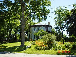
The Deacon West Octagon House, built in 1856 (1854) by Deacon Josiah West, is an historic eleven-room octagon house located at 370 High Street, in Pewaukee, Wisconsin, United States. The wooden sign posted in front of the house states, "Josiah West 1854 Octagon House." It is only one of 19 such structures in the state. Deacon West was a blacksmith in Pewaukee.

Waukesha Beach Railway
Distance: Approx. 5100 meters
Latitude and longitude: 43.0578507,-88.3094258
The Waukesha Beach Railway operated from 1895 until 1949 as an interurban railway from Waukesha to Pewaukee Lake in Wisconsin.

Hindu Temple of Wisconsin
Hindu temple in Wisconsin, United States
Distance: Approx. 2462 meters
Latitude and longitude: 43.09111111,-88.22833333
The Hindu Temple of Wisconsin (HTW), located in Pewaukee, is the oldest Hindu temple in the U.S. state of Wisconsin. As of 2023, it is attended by 2,500 families. A Jain temple is located on the same property.
Weather in this IP's area
clear sky
-18 Celsius
-25 Celsius
-18 Celsius
-18 Celsius
1030 hPa
45 %
1030 hPa
992 hPa
10000 meters
4.91 m/s
7.89 m/s
291 degree
4 %
