Country:
 Canada
Region:
City:
Latitude and Longitude:
Time Zone:
Postal Code:
IP information under different IP Channel
ip-api
Country
Region
City
ASN
Time Zone
ISP
Blacklist
Proxy
Latitude
Longitude
Postal
Route
IPinfo
Country
Region
City
ASN
Time Zone
ISP
Blacklist
Proxy
Latitude
Longitude
Postal
Route
MaxMind
Country
Region
City
ASN
Time Zone
ISP
Blacklist
Proxy
Latitude
Longitude
Postal
Route
Luminati
Country
CARegion
on
City
conestogo
ASN
Time Zone
America/Toronto
ISP
HYDROONETELECOM
Latitude
Longitude
Postal
db-ip
Country
Region
City
ASN
Time Zone
ISP
Blacklist
Proxy
Latitude
Longitude
Postal
Route
ipdata
Country
Region
City
ASN
Time Zone
ISP
Blacklist
Proxy
Latitude
Longitude
Postal
Route
Popular places and events near this IP address

BlackBerry Limited
Canadian technology company
Distance: Approx. 2538 meters
Latitude and longitude: 43.5171578,-80.5158791
BlackBerry Limited (formerly Research In Motion or RIM for short) is a Canadian software company specializing in cybersecurity. Founded in 1984, it developed the BlackBerry brand of interactive pagers, smartphones, and tablets. The company transitioned to providing software and services and holds critical software application patents.

Woolwich, Ontario
Township in Ontario, Canada
Distance: Approx. 3594 meters
Latitude and longitude: 43.56666667,-80.48333333
The Township of Woolwich (local pronunciation: IPA /ˈwʊl̴ɪt͡ʃ/) is a rural township in Southwestern Ontario. The municipality is located in the northeastern part of Waterloo Region and is made up of 10 small communities, with Elmira, Ontario the largest and St. Jacobs, Ontario the second largest.

St. Jacobs, Ontario
Unincorporated community in Ontario, Canada
Distance: Approx. 3922 meters
Latitude and longitude: 43.53472222,-80.55388889
St. Jacobs is an unincorporated suburban community in the township of Woolwich in Waterloo Regional Municipality, Ontario, Canada. It is located north of the city of Waterloo.
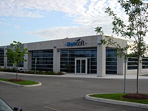
Waterloo Maple
Software company in Canada
Distance: Approx. 4985 meters
Latitude and longitude: 43.506,-80.5478
Waterloo Maple Inc. is a Canadian software company, headquartered in Waterloo, Ontario. It operates under the trade name Maplesoft.
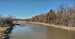
Conestogo River
River in Ontario, Canada
Distance: Approx. 1551 meters
Latitude and longitude: 43.53833333,-80.48638889
The Conestogo River is a river in Waterloo Region and Wellington County in Southwestern Ontario, Canada. The river was named by Mennonite settlers after the Conestoga River in Pennsylvania. In the 1800s there were several different spellings of the name of the river and of the nearby settlement of Conestogo, Ontario but the name ending in "o" became official.

Waterloo–St. Jacobs Railway
Canadian heritage railway
Distance: Approx. 4339 meters
Latitude and longitude: 43.52,-80.552768
The Waterloo-St. Jacobs Railway (WSJR) was a heritage railway west of Toronto that ran between Waterloo and St. Jacobs, Ontario from 1997 to 1999.

Winterbourne, Ontario
Unincorporated community in Ontario, Canada
Distance: Approx. 3482 meters
Latitude and longitude: 43.5575,-80.47111111
Winterbourne (; locally [ˈwɪ̃ɾɝˌbɝːn]) is a village located to the east of the Grand River in the township of Woolwich in the Regional Municipality of Waterloo, Ontario, Canada. It is located just northeast of the city of Waterloo. The fine stonework of the Scottish stonemasons can be seen in many of the older buildings throughout the settlement.

Conestoga Mall (Waterloo, Ontario)
Shopping mall in Waterloo, Ontario
Distance: Approx. 4833 meters
Latitude and longitude: 43.49815833,-80.52700556
Conestoga Mall is a shopping mall located at 550 King Street North in Waterloo, Ontario, Canada. Located at King Street's interchange with the Conestoga Parkway, it is the largest shopping centre in Waterloo, and third-largest in Waterloo Region. The mall is owned and operated by the shopping centre development company Ivanhoé Cambridge, which is a principal real estate subsidiary of Caisse de dépôt et placement du Québec.
St. Luke Elementary School
Catholic primary school in Waterloo, Canada
Distance: Approx. 3263 meters
Latitude and longitude: 43.5094,-80.5045
St. Luke Elementary School is a Catholic primary school in the Eastbridge neighbourhood of Waterloo, Ontario, Canada. The school, located at 550 Chesapeake Drive, instructs students from Junior Kindergarten (JK) to the eighth grade.
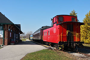
Waterloo Central Railway
Distance: Approx. 4576 meters
Latitude and longitude: 43.5159,-80.552768
The Waterloo Central Railway (WCR) is a non-profit heritage railway owned and operated by the Southern Ontario Locomotive Restoration Society (SOLRS). In May 2007, SOLRS received joint approval from the Region of Waterloo and the City of Waterloo to run trains from Waterloo to St. Jacobs and potentially as far north as Elmira.

Grey Silo Golf Course
Distance: Approx. 2653 meters
Latitude and longitude: 43.517,-80.492
Grey Silo Golf Course is an 18-hole public golf course located in Waterloo, Ontario, Canada. Opened in 2000 and owned by the city of Waterloo, the course is within RIM Park along the Grand River. Designed by Steve Young, it was the host course of the Manulife Financial LPGA Classic, a 72-hole event on the LPGA Tour, from 2012 to 2014.

St. Jacobs Farmers' Market
Market in Woolwich, Ontario, Canada
Distance: Approx. 4956 meters
Latitude and longitude: 43.5114,-80.5541
St. Jacobs Farmers' Market is a farmers' market and flea market in Woolwich, Ontario, Canada. It is located to the south of King Street North, to the east of Weber Street North, and to the west of the railway tracks.
Weather in this IP's area
few clouds
27 Celsius
27 Celsius
26 Celsius
27 Celsius
1022 hPa
41 %
1022 hPa
986 hPa
10000 meters
4.12 m/s
140 degree
20 %
07:03:07
19:30:29