Country:
 Canada
Region:
City:
Latitude and Longitude:
Time Zone:
Postal Code:
IP information under different IP Channel
ip-api
Country
Region
City
ASN
Time Zone
ISP
Blacklist
Proxy
Latitude
Longitude
Postal
Route
IPinfo
Country
Region
City
ASN
Time Zone
ISP
Blacklist
Proxy
Latitude
Longitude
Postal
Route
MaxMind
Country
Region
City
ASN
Time Zone
ISP
Blacklist
Proxy
Latitude
Longitude
Postal
Route
Luminati
Country
CARegion
on
City
brampton
ASN
Time Zone
America/Toronto
ISP
HYDROONETELECOM
Latitude
Longitude
Postal
db-ip
Country
Region
City
ASN
Time Zone
ISP
Blacklist
Proxy
Latitude
Longitude
Postal
Route
ipdata
Country
Region
City
ASN
Time Zone
ISP
Blacklist
Proxy
Latitude
Longitude
Postal
Route
Popular places and events near this IP address
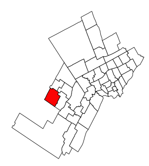
Brampton West (federal electoral district)
Federal electoral district in Ontario, Canada
Distance: Approx. 4030 meters
Latitude and longitude: 43.693,-79.84
Brampton West (French: Brampton-Ouest) is a federal electoral district in Ontario, Canada, that has been represented in the House of Commons of Canada since 2004. Its population was 170,422 in 2006- making it the most populous riding in Canada. The district includes the western part of the city of Brampton excluding the neighbourhood of Madoc.
Brampton Board of Trade
Distance: Approx. 3699 meters
Latitude and longitude: 43.68888889,-79.77305556
The Brampton Board of Trade is a business organization founded in Brampton, Ontario, in 1887. It engages in government lobbying, member discounts, and networking. It previously organized the Brampton Santa Claus Parade (1985-2017).

Brampton GO Station
Railway station in Ontario, Canada
Distance: Approx. 4086 meters
Latitude and longitude: 43.68694444,-79.76472222
Brampton Innovation District GO Station (Brampton Station) is a railway station served by GO Transit and Via Rail, located at 27 Church Street West in downtown Brampton, Ontario, Canada. It is directly connected to the Downtown Brampton Terminal which serves GO Transit and Brampton Transit buses.

Mount Pleasant GO Station
Railway station in Ontario, Canada
Distance: Approx. 1573 meters
Latitude and longitude: 43.675,-79.82166667
Mount Pleasant GO Station is a GO Transit railway station Brampton, Ontario, Canada. Situated on the Kitchener line, it serves the Mount Pleasant district of Brampton. It is located at Bovaird Drive and Ashby Field Drive.
Brampton South (provincial electoral district)
Provincial electoral district in Ontario, Canada
Distance: Approx. 4142 meters
Latitude and longitude: 43.656,-79.757
Brampton South is a provincial electoral district in Ontario. It was created prior to the 1987 election from part of Brampton. It was abolished in 1999 into Bramalea—Gore—Malton—Springdale, Brampton Centre, Brampton West—Mississauga.
Mount Pleasant, Brampton
Neighbourhood in Peel, Ontario, Canada
Distance: Approx. 1528 meters
Latitude and longitude: 43.67666667,-79.81861111
Mount Pleasant is a neighbourhood of Brampton, Ontario, Canada, located in the northwestern portion of the city. Historically, the community was a rural hamlet surrounded by agricultural lands. Since opening the Mount Pleasant GO Station in 2006, the area has experienced rapid suburban growth.
Camp Naivelt
Distance: Approx. 3023 meters
Latitude and longitude: 43.6447,-79.7834
Camp Naivelt (Yiddish: קעמפּ נײַוועלט, lit. 'Camp New World') is a left-wing secular Jewish camping community in Brampton, Ontario, founded in 1925 as a children's summer camp, Camp Kinderland (Yiddish: קעמפּ קינדערלאַנד). It is affiliated with the United Jewish People's Order.
St. Edmund Campion Secondary School
Highschool school in Brampton, Ontario, Canada
Distance: Approx. 3700 meters
Latitude and longitude: 43.69465,-79.83003
St. Edmund Campion Catholic Secondary School is a high school in Brampton, Ontario, Canada. The school is operated by the Dufferin-Peel Catholic District School Board.

Brampton West (provincial electoral district)
Provincial electoral district in Ontario, Canada
Distance: Approx. 4030 meters
Latitude and longitude: 43.693,-79.84
Brampton West is a provincial electoral district in central Ontario, Canada. It was created for the 2007 provincial election. 72.8% of the district was created from Brampton West—Mississauga while 27.2% was carved from Brampton Centre.
St. Augustine Catholic Secondary School
School in Brampton, Ontario, Canada
Distance: Approx. 3451 meters
Latitude and longitude: 43.65827,-79.76503
St. Augustine Catholic Secondary School is a Catholic high school in Brampton, Ontario. This high school is part of the Dufferin-Peel Catholic District School Board.
St. Roch Catholic Secondary School
Catholic high school in Credit Valley, Canada
Distance: Approx. 764 meters
Latitude and longitude: 43.67296,-79.80677
St. Roch Catholic Secondary School is a high school in Credit Valley, Brampton, Ontario, Canada. The school's principal is Jeff Quenneville.
David Suzuki Secondary School
High school in Brampton, Ontario, Canada
Distance: Approx. 1702 meters
Latitude and longitude: 43.6678,-79.7855
David Suzuki Secondary School is an institution located in Brampton, Ontario, Canada. The school is named after Canadian environmental activist David Suzuki. The school draws most of its students from the area bounded by Queen Street West, Hurontario Street, Bovaird Drive West, and Mississauga Road.
Weather in this IP's area
few clouds
8 Celsius
5 Celsius
7 Celsius
9 Celsius
1015 hPa
80 %
1015 hPa
987 hPa
10000 meters
5.66 m/s
270 degree
20 %
06:51:23
19:42:26