Country:
 Canada
Region:
City:
Latitude and Longitude:
Time Zone:
Postal Code:
IP information under different IP Channel
ip-api
Country
Region
City
ASN
Time Zone
ISP
Blacklist
Proxy
Latitude
Longitude
Postal
Route
IPinfo
Country
Region
City
ASN
Time Zone
ISP
Blacklist
Proxy
Latitude
Longitude
Postal
Route
MaxMind
Country
Region
City
ASN
Time Zone
ISP
Blacklist
Proxy
Latitude
Longitude
Postal
Route
Luminati
Country
CARegion
on
City
woodbridge
ASN
Time Zone
America/Toronto
ISP
HYDROONETELECOM
Latitude
Longitude
Postal
db-ip
Country
Region
City
ASN
Time Zone
ISP
Blacklist
Proxy
Latitude
Longitude
Postal
Route
ipdata
Country
Region
City
ASN
Time Zone
ISP
Blacklist
Proxy
Latitude
Longitude
Postal
Route
Popular places and events near this IP address

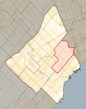
Bramalea, Ontario
Suburban district in Peel, Ontario, Canada
Distance: Approx. 2446 meters
Latitude and longitude: 43.725,-79.7175
Bramalea (Bram-a-lee) is a large suburban district in the City of Brampton, Ontario, Canada. Bramalea was created as an innovative "new town", and developed as a separate community from the original Town of Brampton. Located in the former Chinguacousy Township, it was Canada's first satellite community developed by one of the country's largest real estate developers, Bramalea Consolidated Developments (later Bramalea Limited).

Bramalea GO Station
Railway station in Ontario, Canada
Distance: Approx. 1992 meters
Latitude and longitude: 43.70194444,-79.69111111
Bramalea GO Station is a GO Transit railway and bus station along the Kitchener line in Brampton, Ontario, Canada. It is located at 1713 Steeles Avenue East, near the community of Bramalea at Steeles Avenue East and Bramalea Road. In addition to the Kitchener line train service, it is also served by numerous GO Transit and Brampton Transit bus routes.

Bramalea—Gore—Malton (federal electoral district)
Federal electoral district in Ontario, Canada
Distance: Approx. 558 meters
Latitude and longitude: 43.72333333,-79.69277778
Bramalea—Gore—Malton (formerly known as Brampton—Malton and Bramalea—Gore—Malton—Springdale) was a federal electoral district in Ontario, Canada, that was represented in the House of Commons of Canada. In 2015, it was dissolved into the ridings of Brampton East, Mississauga—Malton, Brampton Centre and Brampton North. The district was created as "Brampton—Malton" in 1987 from Brampton—Georgetown and Mississauga North.

Mississauga—Brampton South
Federal electoral district in Ontario, Canada
Distance: Approx. 2396 meters
Latitude and longitude: 43.7,-79.7
Mississauga—Brampton South was a federal electoral district in Ontario, Canada, that was represented in the House of Commons of Canada from 2004 to 2015. It consists of the parts of the cities of Mississauga and Brampton bounded by a line drawn from the intersection of Highway 401 with the northeastern limit of the City of Mississauga, south along the city limit, southwest along Burnhamthorpe Road East, northwest along Central Parkway East, southwest along Highway 403, northwest along Mavis Road; thence northwesterly along said road to Eglinton Avenue West; thence southwesterly along said avenue to Terry Fox Way; thence northwesterly along said way to Britannia Road West; thence northeasterly along said road to Mavis Road, southwest along Highway 401, northwest along Mississauga Road, northeast along the northwestern limit of the City of Mississauga, northwest along McLaughlin Road, northeast along Steeles Avenue East, southeast along Kennedy Road South, northeast along the northwestern limit of the City of Mississauga, southeast along Dixie Road, and northeast along Highway 401 to the point of commencement. Following the 2012 federal electoral boundaries redistribution, the bulk of the district will be part of the new Mississauga—Malton district, with other parts transferred to Mississauga East—Cooksville, Mississauga Centre, Mississauga—Streetsville, Brampton South, and Brampton Centre.
Holy Name of Mary Catholic Secondary School
High school in Brampton, Canada
Distance: Approx. 2772 meters
Latitude and longitude: 43.7338,-79.7164
Holy Name of Mary Catholic Secondary School is an all-girls regional high school in Brampton, Ontario, Canada founded by the Felician Sisters. Originally located in Mississauga, it relocated to Brampton in 2008. Holy Name of Mary Catholic Secondary School is the only single-sex school in the Dufferin-Peel Catholic District School Board.
Bramalea Secondary School
Public high school in Brampton, Ontario, Canada
Distance: Approx. 1658 meters
Latitude and longitude: 43.715302,-79.707693
Bramalea Secondary School (BSS) is a high school located in Bramalea, Brampton, Ontario, operating under the Peel District School Board established in 1963.
Bramalea—Gore—Malton (provincial electoral district)
Provincial electoral district in Ontario, Canada
Distance: Approx. 90 meters
Latitude and longitude: 43.72027778,-79.68722222
Bramalea—Gore—Malton was a provincial electoral district in Southern Ontario, Canada. It was created for the 2007 provincial election. All of the district was carved from Bramalea—Gore—Malton—Springdale.

10 Peel Centre Drive
Distance: Approx. 2747 meters
Latitude and longitude: 43.71928,-79.72214
10 Peel Centre Drive is a building complex in Brampton, Ontario, Canada that serves as the seat of local government for the Regional Municipality of Peel. The building has been used for regional government offices since its completion in 1980 after relocating from the nearby historic Peel County Courthouse. The complex includes the Peel Regional Council chambers and the offices of Division 21 of the Peel Regional Police.

Bramalea Terminal
Distance: Approx. 2642 meters
Latitude and longitude: 43.71916667,-79.72083333
Bramalea Terminal is a Brampton Transit bus station serving the community of Bramalea in Brampton, Ontario, Canada. It is located at the south west corner of Peel Centre Drive and Central Park Drive on the north side of the Brampton Civic Centre. The customer service centre building is situated in the northerly of two island platform areas, which are accessed by pedestrian cross walks.
Mississauga East—Cooksville (provincial electoral district)
Provincial electoral district in Ontario, Canada
Distance: Approx. 2396 meters
Latitude and longitude: 43.7,-79.7
Mississauga East—Cooksville is a provincial electoral district in Ontario, Canada, that has been represented in the Legislative Assembly of Ontario since the 2007 provincial election.
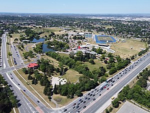
Donald M. Gordon Chinguacousy Park
Park in Brampton, Ontario, Canada
Distance: Approx. 2482 meters
Latitude and longitude: 43.72472222,-79.71805556
Donald M. Gordon Chinguacousy Park, colloquially known as Chinguacousy Park, is a large 40-hectare (100-acre) park in the Bramalea section of Brampton, Ontario, Canada. It is bounded by Queen Street East on the southeast, Bramalea Road on the northeast, and Central Park Drive on the north and west sides. Terry Fox Stadium (Brampton) in the north of the park, sometimes called Terry Fox Track and Field Stadium, has a track and field oval surrounding an artificial turf field with Canadian Football markings and stands for about 1000 spectators.

Kwakiutl (statue)
Totem sculpture by Simon Charlie
Distance: Approx. 2692 meters
Latitude and longitude: 43.72283056,-79.72118056
Kwakiutl (or variously KwaKiutl) is a totem sculpture by Cowichan Tribes artist Simon Charlie, which has caused controversy for its nudity over multiple decades of display in Chinguacousy Township, and later Brampton, both near Toronto in Ontario, Canada. Charlie, also known as Hwunumetse', later received the Order of Canada. The 9-foot-tall cedar wood sculpture is best known for its exposed male genitals.
Weather in this IP's area
clear sky
16 Celsius
15 Celsius
14 Celsius
17 Celsius
1033 hPa
57 %
1033 hPa
1010 hPa
10000 meters
2.57 m/s
190 degree
07:37:09
18:30:07