142.39.71.246 - IP Lookup: Free IP Address Lookup, Postal Code Lookup, IP Location Lookup, IP ASN, Public IP
Country:
 Canada
Region:
City:
Location:
Time Zone:
Postal Code:
ISP:
ASN:
language:
User-Agent:
Proxy IP:
Blacklist:
IP information under different IP Channel
ip-api
Country
Region
City
ASN
Time Zone
ISP
Blacklist
Proxy
Latitude
Longitude
Postal
Route
db-ip
Country
Region
City
ASN
Time Zone
ISP
Blacklist
Proxy
Latitude
Longitude
Postal
Route
IPinfo
Country
Region
City
ASN
Time Zone
ISP
Blacklist
Proxy
Latitude
Longitude
Postal
Route
IP2Location
142.39.71.246Country
caRegion
quebec
City
saint-laurent
Time Zone
America/Montreal
ISP
Language
User-Agent
Latitude
Longitude
Postal
ipdata
Country
Region
City
ASN
Time Zone
ISP
Blacklist
Proxy
Latitude
Longitude
Postal
Route
Popular places and events near this IP address

Montréal–Trudeau International Airport
Airport in Dorval, Quebec, Canada
Distance: Approx. 2780 meters
Latitude and longitude: 45.47055556,-73.74083333
Montréal–Trudeau International Airport (IATA: YUL, ICAO: CYUL) (French: Aéroport International Montréal-Trudeau) or Montréal–Trudeau, formerly known and still commonly referred to as Montréal–Dorval International Airport (Aéroport international Montréal-Dorval), is an international airport in Dorval, Quebec, Canada. It is the only Transport Canada designated international airport serving Montreal and is situated 20 km (12 mi) west of Downtown Montreal. The airport terminals are located entirely in the suburb of Dorval, while one runway is located in the Montreal borough of Saint-Laurent.
Côte Saint-Luc
City in Quebec, Canada
Distance: Approx. 3213 meters
Latitude and longitude: 45.46666667,-73.66666667
Côte Saint-Luc (French pronunciation: [kot sɛ̃ lyk]) is a city on the Island of Montreal in Quebec, Canada. It is a mostly residential suburb of Montreal, within which it forms an enclave. The city is primarily English-speaking, with a large Jewish community.

Wagar High School
Distance: Approx. 2985 meters
Latitude and longitude: 45.46944444,-73.66861111
Wagar High School was a high school at 5785 Parkhaven Avenue in Côte Saint-Luc, Quebec, Canada. It opened its doors in 1963 as part of the Protestant School Board of Greater Montreal (PSBGM) and closed in 2005 as part of the English Montreal School Board (EMSB). At its peak in the mid-70s, Wagar's population topped out at over 1,700 students, despite its having been built to accommodate 1,100.

Saint-Laurent, Quebec
Borough of Montreal in Quebec, Canada
Distance: Approx. 2962 meters
Latitude and longitude: 45.502,-73.707
Saint-Laurent (French pronunciation: [sɛ̃ lɔʁɑ̃] ) is a borough of the city of Montreal, Canada, located in the northern part of the island. Although it is no longer an independent city, it is still commonly known as Ville Saint-Laurent (City of Saint-Laurent) or by its initials, VSL. Saint-Laurent is the largest of Montreal's boroughs by land area. Its population was 98,828 inhabitants in 2016.

Congregation Beth Ora (Saint Laurent)
Distance: Approx. 2767 meters
Latitude and longitude: 45.4971,-73.6886
Congregation Beth Ora (Hebrew: קהלת בית אורה, lit. 'House of Light') is a Modern Orthodox synagogue serving the Ashkenazi Jewish community in Saint-Laurent, Quebec, Canada. Founded in 1953 by William Weiss as "The Jewish Congregation of Saint Laurent", the synagogue adopted its constitution in 1956, and construction was finalized in 1957. The name was later changed to Beth Ora in 1959.

Marquette (provincial electoral district)
Provincial electoral district in Quebec, Canada
Distance: Approx. 2865 meters
Latitude and longitude: 45.45,-73.7
Marquette (French pronunciation: [maʁkɛt]) is a provincial electoral district in the Montreal region of Quebec, Canada, that elects members to the National Assembly of Quebec. It comprises the cities of Dorval, L'Île-Dorval, and the Lachine borough of Montreal. It was created for the 1981 election from parts of Jacques-Cartier, Marguerite-Bourgeoys and Notre-Dame-de-Grâce electoral districts.

Place Vertu
Shopping mall in Montreal, Quebec
Distance: Approx. 2602 meters
Latitude and longitude: 45.498767,-73.706631
Place Vertu is a shopping mall in the borough of Saint-Laurent in Montreal, Quebec, Canada. It is located on Côte-Vertu Boulevard, at the corner of Cavendish Boulevard. The mall is about 830,000 square feet (77,109.5 m2) in size, and has a high-rise building.
RCAF Station Lachine
Distance: Approx. 2776 meters
Latitude and longitude: 45.4706,-73.7408
RCAF Station Lachine was a Royal Canadian Air Force station located near Lachine and Dorval, Quebec, Canada, to the west of Montreal. The location of the station was Dorval Airport, which became the Montréal-Dorval International Airport (now Montréal-Pierre Elliott Trudeau International Airport). RCAF Station Lachine began operation in 1941 as a transit point for the ferrying of aircraft and the transportation of supplies to Europe during the Second World War.

Lachine station
Railway station in Canada
Distance: Approx. 3010 meters
Latitude and longitude: 45.44861111,-73.71111111
Lachine station (French pronunciation: [laʃin]) is a commuter rail station operated by Exo in the borough of Lachine, Canada. It is part of the Vaudreuil–Hudson line. It has no connecting bus routes.
Vanguard School (Quebec)
High school in Saint-Laurent, Quebec, Canada
Distance: Approx. 2517 meters
Latitude and longitude: 45.492,-73.684
Vanguard School is a high school and elementary school situated in Saint-Laurent, Quebec on the Island of Montreal. Vanguard School is the only school to offer an elementary and high school program in two languages of instruction for 7 to 16 years-olds with severe learning disabilities by offering them the resources that will enable them to learn and to experience academic success. Vanguard School is a private school declared in the public interest, it offers adapted educational services, in English or in French, to students with severe learning disabilities.
John Grant High School
High school in Côte Saint-Luc, Quebec, Canada
Distance: Approx. 2985 meters
Latitude and longitude: 45.46944444,-73.66861111
John Grant High School (French: École secondaire John Grant) is a high school located in Côte Saint-Luc, Quebec, Canada and a part of the English Montreal School Board (EMSB). It was previously a part of the Protestant School Board of Greater Montreal.
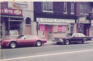
J&R Kosher Meat and Delicatessen
Restaurant in Quebec, Canada
Distance: Approx. 3116 meters
Latitude and longitude: 45.47615278,-73.66599167
J&R Kosher Meat and Delicatessen is a Montreal kosher butcher and delicatessen established in 1952 by Robert Nemes, a Holocaust survivor and immigrant from Romania. It is currently at 5800 Cavendish Blvd in the heart of the city's Jewish community. J&R is the oldest and one of the most famous remaining kosher meat shops in Montreal.
Weather in this IP's area
few clouds
-6 Celsius
-13 Celsius
-6 Celsius
-5 Celsius
1016 hPa
66 %
1016 hPa
1012 hPa
10000 meters
8.23 m/s
11.32 m/s
270 degree
20 %