Country:
 Canada
Region:
City:
Latitude and Longitude:
Time Zone:
Postal Code:
IP information under different IP Channel
ip-api
Country
Region
City
ASN
Time Zone
ISP
Blacklist
Proxy
Latitude
Longitude
Postal
Route
IPinfo
Country
Region
City
ASN
Time Zone
ISP
Blacklist
Proxy
Latitude
Longitude
Postal
Route
MaxMind
Country
Region
City
ASN
Time Zone
ISP
Blacklist
Proxy
Latitude
Longitude
Postal
Route
Luminati
Country
CARegion
ab
City
calgary
ASN
Time Zone
America/Edmonton
ISP
Equinix (EMEA) Acquisition Enterprises B.V.
Latitude
Longitude
Postal
db-ip
Country
Region
City
ASN
Time Zone
ISP
Blacklist
Proxy
Latitude
Longitude
Postal
Route
ipdata
Country
Region
City
ASN
Time Zone
ISP
Blacklist
Proxy
Latitude
Longitude
Postal
Route
Popular places and events near this IP address

Beltline, Calgary
Neighbourhood in Calgary, Alberta, Canada
Distance: Approx. 364 meters
Latitude and longitude: 51.03972222,-114.07138889
Beltline is a region of central Calgary, Alberta, Canada. The area is located immediately to the south of Calgary's downtown (south of 9th Avenue and the Canadian Pacific Railway tracks), and is sometimes considered part of downtown. The neighbourhood is bounded on the south by 17th Avenue, on the west by 14th Street West and on the east by the Elbow River.
Red Mile
Distance: Approx. 483 meters
Latitude and longitude: 51.03772,-114.08156
The Red Mile is the name given to a stretch of 17 Avenue SW in Calgary, Alberta, Canada during the Calgary Flames 2004 Stanley Cup playoff run, which ended with a loss to the Tampa Bay Lightning in seven games in the finals. It gained worldwide notoriety both for the relative lack of violence while upwards of 55,000 fans celebrated their team's success. The 'Red' originates from the home team colour of the Calgary Flames' jerseys, red, similarly characterized by the 'Sea of Red' seen at many home games in the Saddledome; 'Sea of Red' and 'C of Red' (for the Flames' flaming C) is a play on words.
Calgary Victoria Park
Defunct provincial electoral district in Alberta, Canada
Distance: Approx. 261 meters
Latitude and longitude: 51.04,-114.08
Calgary Victoria Park was a provincial electoral district in Calgary, Alberta, Canada, mandated to return a single member to the Legislative Assembly of Alberta using the first past the post method of voting from 1967 to 1971. The riding existed for four years and would be contested once for the 1967 election. After which the Alberta Legislature passed the 1970 An Act to amend The Election Act and The Legislative Assembly Act to redraw provincial electoral districts.
Western Canada High School
Public school in Calgary, Alberta
Distance: Approx. 366 meters
Latitude and longitude: 51.03736,-114.077302
Western Canada High School is a public high school in Calgary, Alberta that has operated since 1929. The high school was antedated by Western Canada College, a boys' preparatory school in the style of a British public school that opened in 1903. The College existed until the end of the 1926 academic year when it closed due to financial problems.
Calgary Fringe Festival
Annual Fringe theatre festival in Calgary, Canada
Distance: Approx. 364 meters
Latitude and longitude: 51.03972222,-114.07138889
The Calgary Fringe Festival is an annual Fringe theatre festival in Calgary, Alberta.
Wildrose Party
Defunct political party in Alberta, Canada
Distance: Approx. 342 meters
Latitude and longitude: 51.0434,-114.0744
The Wildrose Party (legally Wildrose Political Association, formerly the Wildrose Alliance Political Association) was a conservative provincial political party in Alberta, Canada. The party was formed by the merger in early 2008 of the Alberta Alliance Party and the unregistered Wildrose Party of Alberta. The wild rose is Alberta's provincial flower.

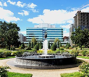
Central Memorial Park
Distance: Approx. 396 meters
Latitude and longitude: 51.04113,-114.07081
Central Memorial Park is a park located in central Calgary's Beltline district. Sometimes referred to as Central Park or as Memorial Park, the area is home to the Memorial Park Library, an equestrian statue of Russell Lambert Boyle, and a cenotaph. The former Colonel Belcher Veterans Hospital was located across 4th street SW to the west, now the site of the Sheldon M. Chumir Centre.
Sheldon M. Chumir Centre
Hospital in Alberta, Canada
Distance: Approx. 315 meters
Latitude and longitude: 51.0412,-114.072
The Sheldon M. Chumir Centre is a health centre located in Calgary, Alberta. The facility is administered by the Calgary Zone of Alberta Health Services. The centre provides 24/7 Urgent Care services but is not a full-service hospital and does not admit any patients for overnight stays.
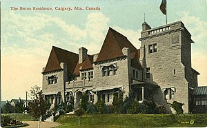
Burns Manor
Building in Alberta, Canada
Distance: Approx. 317 meters
Latitude and longitude: 51.04118,-114.07196
Burns Manor was the Calgary residence of Senator Pat Burns, a successful businessman who founded Burns Meat. It was located at 510 13th Avenue S.W. in the Beltline District of Calgary, Alberta. Construction started in July 1900 and was completed in January 1903.

Lougheed House
Canadian Historic Victorian mansion in Calgary, Alberta
Distance: Approx. 53 meters
Latitude and longitude: 51.040591,-114.07715
Lougheed House, or as it was originally known Beaulieu, (French meaning "beautiful place") is a National Historic Site located in the Beltline district of Calgary, Alberta. Originally constructed in 1891 as a home for Senator James Alexander Lougheed KCMG PC KC and his wife Isabella Clarke Hardisty, the structure has since become an iconic heritage building in Calgary. Lougheed House is operated by Lougheed House Conservation Society, an independent, non-profit society devoted to the restoration and public enjoyment of the historic house and its Gardens.
Calgary Design District
Shopping area in Calgary, Alberta, Canada
Distance: Approx. 241 meters
Latitude and longitude: 51.042757,-114.076645
The Design District is a shopping area in Calgary, Alberta, Canada, centered on 11th Avenue S.W.

Barb Scott Park
Park in Calgary, Alberta, Canada
Distance: Approx. 493 meters
Latitude and longitude: 51.04138889,-114.08333333
Barb Scott Park is an urban park located in downtown Calgary. The park was named in honor of Barb Scott, a Calgary Alderman who served on council for 24 years. The park is located on the same block as the Calgary Board of Education headquarters, the Dr Carl Safran Centre.
Weather in this IP's area
clear sky
15 Celsius
14 Celsius
12 Celsius
16 Celsius
1011 hPa
57 %
1011 hPa
895 hPa
10000 meters
1.34 m/s
3.13 m/s
198 degree
07:01:42
20:06:13