Country:
 USA
USARegion:
City:
Latitude and Longitude:
Time Zone:
Postal Code:
IP information under different IP Channel
ip-api
Country
Region
City
ASN
Time Zone
ISP
Blacklist
Proxy
Latitude
Longitude
Postal
Route
IPinfo
Country
Region
City
ASN
Time Zone
ISP
Blacklist
Proxy
Latitude
Longitude
Postal
Route
MaxMind
Country
Region
City
ASN
Time Zone
ISP
Blacklist
Proxy
Latitude
Longitude
Postal
Route
Luminati
Country
USRegion
ca
City
sanfrancisco
ASN
Time Zone
America/Los_Angeles
ISP
AS-SONICTELECOM
Latitude
Longitude
Postal
db-ip
Country
Region
City
ASN
Time Zone
ISP
Blacklist
Proxy
Latitude
Longitude
Postal
Route
ipdata
Country
Region
City
ASN
Time Zone
ISP
Blacklist
Proxy
Latitude
Longitude
Postal
Route
Popular places and events near this IP address

24th Street Mission station
Rapid transit station in San Francisco, California, US
Distance: Approx. 601 meters
Latitude and longitude: 37.752,-122.4187
24th Street Mission station is a Bay Area Rapid Transit (BART) station located under Mission Street at 24th Street in the Mission District of San Francisco, California. The station is served by the Red, Yellow, Green, and Blue lines.

Garfield Square
Distance: Approx. 46 meters
Latitude and longitude: 37.7502,-122.41222
Garfield Square, also known as Garfield Park, is a 3.46-acre (14,000 m2) city park located in the Mission District of San Francisco, California. It is bounded by 25th Street to the north, 26th Street to the south, Treat Avenue to the west, and Harrison Street to the east and was first opened in 1884. Previously the location of the Recreation Grounds baseball park which was the first professional baseball park in California, dating to 1868.
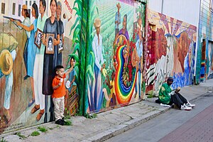
Balmy Alley
Street in San Francisco, California
Distance: Approx. 134 meters
Latitude and longitude: 37.751777,-122.412406
Balmy Alley (formally Balmy Street) is a one-block-long alley that is home to the most concentrated collection of murals in the city of San Francisco. It is located in the south central portion of the Inner Mission District in Calle 24 between 24th Street and Garfield Square. Since 1973, most buildings on the street have been decorated with a mural.
Camp Alert (California)
Distance: Approx. 364 meters
Latitude and longitude: 37.75138889,-122.41611111
Camp Alert was an American Civil War Union Army, training camp located at the Pioneer Race Course, near San Francisco, north of Bernal Heights. Today the site location is within the city, between 24th and 25th Streets (north and south) and Folsom and Mission Streets (east and west). Camp Alert was first used in 1862, as the place where the 2nd Regiment California Volunteer Cavalry was headquartered, organized and trained before moving to their headquarters to Utah Territory.

Pioneer Race Course
Distance: Approx. 364 meters
Latitude and longitude: 37.75138889,-122.41611111
Pioneer Race Course, also known as the Pioneer Race Track, was a horse race track opened in March 1851, in the southern Mission District of San Francisco, California. Pioneer was the first race course in San Francisco. At the time that it was built, no streets existed in the neighborhood.
The Laundry SF
Art gallery in San Francisco, California, U.S.
Distance: Approx. 490 meters
Latitude and longitude: 37.74916667,-122.41736111
The Laundry SF, or simply The Laundry, is a contemporary art gallery, event space and cafe, founded in 2015 and located in San Francisco’s Mission District. The Laundry curates exhibitions, which includes public programming around civics, fine arts, music, comedy, and live performances. The Laundry hosts a mix of works by emerging and established Bay Area and global artists.

Acción Latina
Nonprofit organization in San Francisco
Distance: Approx. 264 meters
Latitude and longitude: 37.752888,-122.411308
Acción Latina is a Latino cultural nonprofit organization founded in 1970, and located in the Mission District at 2958-24th Street, San Francisco, California. They publish El Tecolote bilingual newspaper, lead the Paseo Artístico community art stroll, and operate the Juan R. Fuentes Gallery. Acción Latina hosts diverse community driven visual, literary and performing arts events.

Precita Park
Municipal park in San Francisco, California
Distance: Approx. 395 meters
Latitude and longitude: 37.747056,-122.412028
Precita Park is a 2.06-acre (0.83 ha) municipal park in San Francisco, California. It is located at Folsom Street and Precita Avenue, which bounds both the north and south sides of the park, and is also bordered by Alabama Street, in the Bernal Heights neighborhood.
La Taqueria
Restaurant in California, United States
Distance: Approx. 529 meters
Latitude and longitude: 37.7509,-122.4181
La Taqueria is a restaurant in San Francisco, California. In 2017 it was named one of America's Classics by the James Beard Foundation.
Marlena (restaurant)
Restaurant in San Francisco, California, U.S.
Distance: Approx. 451 meters
Latitude and longitude: 37.74666667,-122.41333333
Marlena was a restaurant serving American cuisine in Bernal Heights, San Francisco, California. The restaurant opened in 2020. The restaurant closed suddenly in 2023.
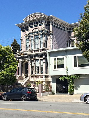
Havens Mansion and Carriage House
Building in San Francisco
Distance: Approx. 346 meters
Latitude and longitude: 37.751188,-122.415965
The Havens Mansion and Carriage House is a historic residential building in the Mission District of San Francisco, California, United States. It was listed as a San Francisco Designated Landmark since 1981. It is a private residence and is not open to the public.

Sunshine School (San Francisco, California)
1937 school building in San Francisco, California, US
Distance: Approx. 254 meters
Latitude and longitude: 37.750444,-122.409222
Sunshine School is a historic 1937 school building and former school in the Mission District neighborhood in San Francisco, California, U.S.. It was first built as a private school for students with physical disabilities; and it later became a continuation high school. It also went by the names Sunshine Orthopedic School, Sunshine High School, and as Hilltop High School.
Weather in this IP's area
scattered clouds
19 Celsius
19 Celsius
16 Celsius
25 Celsius
1011 hPa
77 %
1011 hPa
1009 hPa
10000 meters
6.17 m/s
310 degree
40 %
06:55:24
19:11:08