Country:
 USA
USARegion:
City:
Latitude and Longitude:
Time Zone:
Postal Code:
IP information under different IP Channel
ip-api
Country
Region
City
ASN
Time Zone
ISP
Blacklist
Proxy
Latitude
Longitude
Postal
Route
IPinfo
Country
Region
City
ASN
Time Zone
ISP
Blacklist
Proxy
Latitude
Longitude
Postal
Route
MaxMind
Country
Region
City
ASN
Time Zone
ISP
Blacklist
Proxy
Latitude
Longitude
Postal
Route
Luminati
Country
USRegion
ca
City
oakland
ASN
Time Zone
America/Los_Angeles
ISP
AS-SONICTELECOM
Latitude
Longitude
Postal
db-ip
Country
Region
City
ASN
Time Zone
ISP
Blacklist
Proxy
Latitude
Longitude
Postal
Route
ipdata
Country
Region
City
ASN
Time Zone
ISP
Blacklist
Proxy
Latitude
Longitude
Postal
Route
Popular places and events near this IP address

Green Valley, Solano County, California
Census-designated place in California, United States
Distance: Approx. 2696 meters
Latitude and longitude: 38.25944444,-122.16444444
Green Valley is a census-designated place (CDP) located in Solano County, California, United States. It sits in the northeast corner of the San Francisco Bay Area and is located approximately 45 miles (72 km) from Sacramento, approximately 38 miles (61 km) from San Francisco, approximately 32 miles (51 km) from Oakland, less than 15 miles (24 km) from Napa Valley, and less than 15 miles (24 km) from both the Carquinez Bridge and the Benicia Bridge. The use of "Green Valley" as a place name predates the CDP designation by over a century; a Green Valley Township appears on an 1890 map of Solano County.

Solano Community College
Public college in Fairfield, California, US
Distance: Approx. 1808 meters
Latitude and longitude: 38.2327,-122.1263
Solano Community College (SCC) is a public community college in Fairfield, California, with additional centers in Vacaville and Vallejo. The college is part of California Community Colleges System. SCC's service area includes all of Solano County, and the town of Winters in Yolo County.

Cordelia, California
Unincorporated community in California, United States
Distance: Approx. 3870 meters
Latitude and longitude: 38.21055556,-122.13583333
Cordelia is an unincorporated community in Solano County, California, United States. Cordelia is located at the junction of Interstate 80 and California State Route 12 and at the northern end of Interstate 680, 7 miles (11 km) west of Fairfield, which has annexed substantial portions of its surroundings.
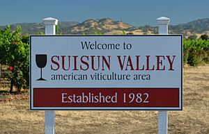
Suisun Valley AVA
American Viticultural Area in California
Distance: Approx. 4406 meters
Latitude and longitude: 38.281,-122.118
The Suisun Valley AVA is an American Viticultural Area in Solano County, California, located just east of the Napa Valley wine region in the Coast Range. It was established as a wine appellation on 27 December 1982.

Fairfield and Suisun Transit
Californian public bus service operator
Distance: Approx. 6207 meters
Latitude and longitude: 38.24833333,-122.06861111
Fairfield Transit (FAST) provides general public fixed route bus service through eight local routes. All FAST buses are wheelchair accessible and most are equipped with bike racks. In 2023, the system had a ridership of 233,800, or about 700 per weekday as of the second quarter of 2024.
Solano County Green Valley AVA
Distance: Approx. 2069 meters
Latitude and longitude: 38.243,-122.163
The Solano County Green Valley AVA is an American Viticultural Area located in Solano County, California. Located southeast of the Napa Valley AVA, Green Valley is about 1 mile (1.6 km) wide and 4 miles (6.4 km) long. The valley is close to San Pablo Bay and thus has a maritime climate.

Rockville, California
Unincorporated community in California, United States
Distance: Approx. 1515 meters
Latitude and longitude: 38.24416667,-122.12222222
Rockville is a small unincorporated community in northern-central Solano County, California, southwest of Fairfield and closest to Cordelia. Yulyul, the main village of the Suisunes (a Patwin people of the Suisun Bay region), is believed to be where Rockville is located today. The main economic activities are farming, tourism, and the large regional Rockville Cemetery.

Mankas Corner, California
Unincorporated community in California, United States
Distance: Approx. 5390 meters
Latitude and longitude: 38.2863023,-122.106913
Mankas Corner is an unincorporated community in the Suisun Valley AVA, is an American Viticulture Area in Solano County, California.
Wild Horse Creek (Solano County)
Distance: Approx. 2878 meters
Latitude and longitude: 38.26102778,-122.16552778
Wild Horse Creek is a small principal stream located in the Vaca Mountains within northern Solano County, California. It flows from Lake Madigan and Lake Frey, and joins with Green Valley Creek.

Fairfield Transportation Center
Distance: Approx. 6225 meters
Latitude and longitude: 38.24882,-122.06845
The Fairfield Transportation Center or FTC is a bus station in Fairfield, California, United States. The facility serves as a bus hub for transportation on local, commuter, and long-distance bus services. There are plans to expand the center.

Rockville Hills Regional Park
Park in California, United States
Distance: Approx. 49 meters
Latitude and longitude: 38.245,-122.14
Rockville Hills Regional Park is a 633-acre (~256 hectare, 2.56 square kilometer) regional park in the city of Fairfield, Solano County, California, United States. The park is known for its volcanic rocks, thin topsoil, grasses, and blue oak trees. There are also oak woodlands, grassland savannas, chaparral and some aquatic habitats.
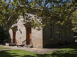
Rockville Stone Chapel
Building in Solano County, California
Distance: Approx. 1571 meters
Latitude and longitude: 38.24746,-122.12176
An outgrowth of local camp meetings, Rockville Stone Chapel was constructed in the fall of 1856, in use by Christmas of that year, and dedicated in February 1857. Divisions in the congregation over slavery soon split the congregation, with the Northern faction splitting off at Christmas Eve 1863 to form their own church. Attendance at the chapel slowly declined, with the last resident pastor leaving in 1895.
Weather in this IP's area
clear sky
24 Celsius
24 Celsius
20 Celsius
29 Celsius
1009 hPa
53 %
1009 hPa
997 hPa
10000 meters
13.86 m/s
16.09 m/s
242 degree
06:54:13
19:10:08